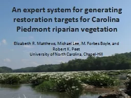
Elizabeth R Matthews Michael Lee M Forbes Boyle and Robert K Peet University of North Carolina ChapelHill CVSEEP restoration protocol Exploit a broad array of reference plots ID: 389000
Download Presentation The PPT/PDF document "An expert system for generating restorat..." is the property of its rightful owner. Permission is granted to download and print the materials on this web site for personal, non-commercial use only, and to display it on your personal computer provided you do not modify the materials and that you retain all copyright notices contained in the materials. By downloading content from our website, you accept the terms of this agreement.
Slide1
An expert system for generating restoration targets for Carolina Piedmont riparian vegetation
Elizabeth R. Matthews,
Michael
Lee, M. Forbes Boyle, and Robert K.
Peet
University
of North Carolina,
Chapel-HillSlide2
CVS-EEP restoration protocol
Exploit a broad array of reference plots
Derive site-specific restoration
targets
CVS plot and NVC data
Design
site-specific restoration plan
Implement the plan
Monitor change and assess success
Employ adaptive management along the waySlide3
CVS-EEP restoration protocol
Exploit a broad array of reference plots
Derive site-specific restoration
targets
CVS plot and NVC data
Design
site-specific restoration plan
Implement the plan
Monitor change and assess success
Employ adaptive management along the waySlide4
Quantitative vegetation descriptions restoration targets
Quantitative vegetation descriptions
Carolina Vegetation Survey
http://cvs.bio.unc.edu/
U.S. National Vegetation Classification
http://www.natureserve.org/explorer/
Match vegetation descriptions to restoration sites
Cost-effective
Improvement on traditional approachesSlide5
Classification and description of vegetation types
Critical environmental fields defined
Restoration sites identified and environmental data collected
Restoration sites matched to described vegetation types
Planting lists generated from vegetation type descriptions
How to do this? Slide6
Case study: Piedmont alluvial vegetation
Quantitative classification of NC alluvial vegetation
North Carolina Ecosystem Enhancement Program restoration sitesSlide7
Classification and description of vegetation types
Critical environmental fields defined
Restoration sites identified and environmental data collected
Restoration sites matched to described vegetation types
Planting lists generated from vegetation type descriptions
How to do this? Slide8
Classification and description of vegetation typesCollect reference site field dataClassify communities using standard quantitative techniques
Cluster analysis;
discriminant
analyses; ordinationSlide9
Vegetation Type Descriptions: field data
Carolina Vegetation Survey (CVS) protocol
20
m
×
50
m
plots
(
Peet
et al 1998)Cover
by strataSoil samples, environmental data,
and geomorphologySlide10
Vegetation Type Descriptions:
field dataSlide11
Vegetation Type Descriptions:
field dataSlide12
Flexible beta,
β
= -0.25
Cover by strata
2-tier, hierarchical classification
5 higher-level groups recognized
14 vegetation types recognizedSlide13
• *
Quantitative Vegetation Descriptions
Small streams
Oak-hickory flats
Large river levees
Bottomlands and
swamp forestsSlide14
Quantitative Vegetation DescriptionsSlide15
Classification as a guide to NVC revision
ID
N
Alluvial vegetation type
NVC community type (with CEGL code)
I. Small streams and narrow floodplain forests
Ia.
18
Liriodendron
tulipifera
– Liquidambar
styraciflua
/
Lindera
benzoin
/
Amphicarpaea
bracteata
Forest
><
4418
Liquidambar
styraciflua
- Liriodendron
tulipifera
/
Lindera
benzoin
/
Arisaema
triphyllum
Forest
Ia.
><
7329
Liquidambar
styraciflua
- Liriodendron
tulipifera
/
Onoclea
sensibilis
Forest
Ia.
>
7321
Fagus
grandifolia
- Acer
barbatum
/
Asimina
triloba
/
Toxicodendron
radicans /
Carex
blanda
Forest
Ib.
6
Liriodendron
tulipifera
-
Betula
nigra
/
Cornus
florida
/
Sanicula
canadensis
var.
canadensis
Forest
<
4418
Liquidambar
styraciflua
- Liriodendron
tulipifera
/
Lindera
benzoin
/
Arisaema
triphyllum
Forest
II.
Oak-hickory flats
IIa
.
32
Liquidambar
styraciflua
-
Quercus
nigra
/
Carpinus
caroliniana
/
Mitchella
repens
Forest
><
4419
Liriodendron
tulipifera
/
Asimina
triloba
/
Arundinaria
gigantea
ssp.
gigantea
Forest
IIa
.
><
7329
Liquidambar
styraciflua
- Liriodendron
tulipifera
/
Onoclea
sensibilis
Forest
IIb
.
3
Liquidambar
styraciflua
-
Quercus
pagoda-
Carya
cordiformis
/
Asimina
triloba
/
Arundinaria
tecta
Forest
><
4419
Liriodendron
tulipifera
/
Asimina
triloba
/
Arundinaria
gigantea
ssp.
gigantea
Forest
IIc
.
8
Carya
carolinae-septentrionalis
- Acer
floridanum
/
Aesculus
sylvatica
/
Zizia
aurea
Forest
><
8487
Quercus
shumardii
-
Quercus
michauxii
-
Quercus
nigra
/ Acer
barbatum
-
Tilia
americana
var.
heterophylla
Forest
IIc
.
><
7356
Quercus
pagoda -
Quercus
phellos
-
Quercus
lyrata
-
Quercus
michauxii
/
Chasmanthium
latifolium
ForestSlide16
ID
N
Alluvial vegetation type
NVC community type (with CEGL code)
I. Small streams and narrow floodplain forests
Ia.
18
Liriodendron
tulipifera
– Liquidambar
styraciflua
/
Lindera
benzoin
/
Amphicarpaea
bracteata
Forest
><
4418
Liquidambar
styraciflua
- Liriodendron
tulipifera
/
Lindera
benzoin
/
Arisaema
triphyllum
Forest
Ia.
><
7329
Liquidambar
styraciflua
- Liriodendron
tulipifera
/
Onoclea
sensibilis
Forest
Ia.
>
7321
Fagus
grandifolia
- Acer
barbatum
/
Asimina
triloba
/ Toxicodendron radicans / Carex blanda ForestIb.6Liriodendron tulipifera - Betula nigra / Cornus florida / Sanicula canadensis var. canadensis Forest <4418Liquidambar styraciflua - Liriodendron tulipifera / Lindera benzoin / Arisaema triphyllum ForestII. Oak-hickory flatsIIa.32Liquidambar styraciflua - Quercus nigra / Carpinus caroliniana / Mitchella repens Forest ><4419Liriodendron tulipifera / Asimina triloba / Arundinaria gigantea ssp. gigantea Forest IIa. ><7329Liquidambar styraciflua - Liriodendron tulipifera / Onoclea sensibilis ForestIIb.3Liquidambar styraciflua- Quercus pagoda- Carya cordiformis/ Asimina triloba/ Arundinaria tecta Forest ><4419Liriodendron tulipifera / Asimina triloba / Arundinaria gigantea ssp. gigantea Forest IIc.8Carya carolinae-septentrionalis - Acer floridanum / Aesculus sylvatica/ Zizia aurea Forest ><8487Quercus shumardii - Quercus michauxii - Quercus nigra / Acer barbatum - Tilia americana var. heterophylla ForestIIc. ><7356Quercus pagoda - Quercus phellos - Quercus lyrata - Quercus michauxii / Chasmanthium latifolium ForestIII. Large river levee forestsIIIa.33Ulmus americana - Celtis laevigata/ Lindera benzoin / Osmorhiza longistylis Levee Forest>7730Platanus occidentalis - Celtis laevigata - Fraxinus pennsylvanica / Lindera benzoin - Ilex decidua / Carex retroflexa ForestIIIa. ><7340Platanus occidentalis - Liquidambar styraciflua / Carpinus caroliniana - Asimina triloba ForestIIIa. ><4419Liriodendron tulipifera / Asimina triloba / Arundinaria gigantea ssp. gigantea ForestIIIb.30Fraxinus pennsylvanica- Platanus occidentalis / Acer negundo/ Chasmanthium latifolium Levee Forest~7340Platanus occidentalis - Liquidambar styraciflua / Carpinus caroliniana - Asimina triloba ForestSlide17
Classification and description of vegetation types
Critical environmental fields defined
Restoration sites identified and environmental data collected
Restoration sites matched to described vegetation types
Planting lists generated from vegetation type descriptions
How to do this? Slide18
Identify critical environmental variablesClassification methodsRandom Forests
Preliminary list of environmental predictors established via:
past field work
expert knowledge
published literature
reference classifications
Easily
obtainable, GIS-derived environmental variables
Add graphic related to literature
evironment
or
gisSlide19
Classification methods, particularly Random Forests, great at identifying and ranking important variablesSlide20
Classification and description of vegetation types
Critical environmental fields defined
Restoration sites identified and environmental data collected
Restoration sites matched to described vegetation types
Planting lists generated from vegetation type descriptions
How to do this? Slide21
Wells Creek,XXX County
Mason Farm,
Orange CountySlide22
Sandy Creek,
XXX County
UT to Haw,
XXX County
UT to
West Fork Deep,
XXX County
Mill Creek,
XXX CountySlide23
Collected environmental data (field and GIS) at each siteSlide24
Classification and description of vegetation types
Critical environmental fields defined
Restoration sites identified and environmental data collected
Restoration sites matched to described vegetation types
Planting lists generated from vegetation type descriptions
How to do this? Slide25
Quantitative matching
Bray-Curtis
dissimilarity metric (Bray & Curtis 1957), defined as,
where
N
i
=
i
th
environmental variable at the new site,
G
i
= group average for
i
th environmental variable,
wi = weight for i
th
environmental variable.Slide26Slide27
Classification and description of vegetation types
Critical environmental fields defined
Restoration sites identified and environmental data collected
Restoration sites matched to described vegetation types
Planting lists generated from vegetation type descriptions
How to do this? Slide28Slide29Slide30Slide31Slide32
Planting listsPlanting lists may be edited from type-descriptions
dispersal-limited
rare species
types
with high
cover/constancy
of early-successional speciesSlide33
Future directionsBroader implementation– other systems, other classificationsFine-tuning of the toolFeedback!
Download the tool at: Slide34
ThanksSupport for this project came from the NC Ecosystem Enhancement Program, North Carolina Beautiful, and the Society of Wetland Scientists
Forbes Boyle, Brenda
Wichmann
,
Jessi
Outzs
, Jose
Zúñiga
, Megan
Faestel
,
Brucie Sorrie
, Richard LeBlond, Mike Schafale, and the Plant Ecology Lab at UNCSlide35
Questions?