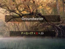
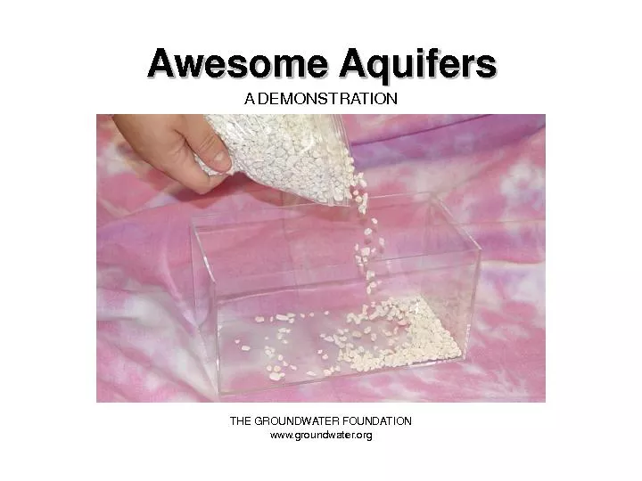
G D S What is an Aquifer Rocks and sediments have pores spaces Rock limestone granite sandstone etc Sand and gravel When pores are full of water that media is saturated Contiguous areas of saturated media form an aquifer ID: 677534
Download Presentation The PPT/PDF document "Groundwater P = Q ET" is the property of its rightful owner. Permission is granted to download and print the materials on this web site for personal, non-commercial use only, and to display it on your personal computer provided you do not modify the materials and that you retain all copyright notices contained in the materials. By downloading content from our website, you accept the terms of this agreement.
Slide1
Groundwater
P = Q + ET +
G
+
D
SSlide2
What is an Aquifer?
Rocks and sediments have pores (spaces)Rock (limestone, granite, sandstone etc.)Sand and gravel
When pores are
full of water
that media is saturated
Contiguous areas of saturated media form an aquifer
Aquifers can be layered
Confined vs. Unconfined
Aquifers have the capacity to transmit water through interconnected poresSlide3
Floridan Aquifer
ExtentSlide4
High Plains Aquifer
(
Ogalalla
)Slide5
ConfinementSlide6
Cross-Section– Floridan AquiferSlide7
Transmissivity
How much water can be moved horizontallyFunction of thickness and Ksat
Good measure of well productivity
Floridan is the most transmissive aquifer in the worldSlide8Slide9
Loss of PotentialSlide10Slide11
Artesian Springs
Where a confining layer exists, there may be a pressure potential in the aquifer HIGHER than the gravity potential of the surface.When tapped, water flows upwardsSlide12
Potentiometric Surface
Elevation of “free water surface”Where this surface and the ground intersect (and there’s no confinement) water seeps Slide13Slide14Slide15
Relevant Questions
Where is the water going?Potentiometric (piezometric) surfaceHow much water is moving? How quickly?Potentiometric surface and Darcys LawWhat level of natural assimilation is occuring?
Water quality modelingSlide16
Gainesville’s Well Field
Also Lake City
Jasper
Geology
Land use
Conservation EasementSlide17
Murphree Wellfield Cone of Depression
1988 (Observed)
2010 (Predicted)Slide18
How to make a sinkhole
Pray for lots of Rain
Suck a lot of waterSlide19
Freeze Protection
To protect strawberry yield during a January freeze in 2010, ~ 2 billion gallons per day of water pumped over a 5 day period. Voila.Slide20
Invasion
Fire
Subsidence
Degraded wildlife habitatSlide21
Soil water movement across a watershed boundary.
P=Q+ET+
G
+
Δ
S
Q
groundwater
= K A
Δ
H/L
Darcy’s Law
Darcy’s law
can calculate
vertical leakage through a clay
layer AND lateral flow through a seepage face.
Q is water crossing the defined area of the boundary in m
3
/daySlide22
K is hydraulic
conductivity, or the capacity of the media to transmit water
Most meaningful as saturated hydraulic conductivity
K
sat
(m/day). Why?
Q=
K
A
Δ
H/LSlide23
Measuring
Ksat
Constant Head Method
Constant depth of water (~50mm) on top of a saturated soil column with known dimensions (diameter, length)
Outflow volume collected over a period of time (e.g., 5
hrs
)
Darcy’s Law to solve for
KsatSlide24
Measuring Ksat
Hvorslev MethodField measurement in screened wells
K only
determined
2
4
6
8
10
minutes
.1
1
.2
.3
.4
.5
.6
.7
.8
H/H
o
t
37
Log scale
Linear scale
H/H
o
=.37
casing
Gravel pack
S
creen
L
e
L
e
/R must be >8
R
high K
material
rSlide25
Approximate
Ksat and Uses
Ksat
(cm/h)
Comments
>50
Beach sand/Golf Course Greens
5
Very sandy soils, cannot filter pollutants
0.5
Suitable for most agricultural, recreational, and urban uses
0.05
Clayey, Too slow for most uses
<0.005
Extremely slow; good if compacted material is neededSlide26
Δ
H is the difference in H between two points
Water flows from high
pressure
to
low
pressure (could
be “up”)
H
= level of water in an open well above some datum
H
A
= ? H
B
= ?
Δ
H = ?
Flow Direction?!?Slide27
H @ D?
H@F?ΔH?
Direction?
10
9
8
7
6
5
4
3
2
1
0Slide28
Δ
H AD? Dir?
Δ
H BF? Dir?
Δ
H AF? Dir?
Δ
H/L BF?Slide29
Q=K A
ΔH/L
K?
A?
Δ
H?
L?
Vertical leakage problem
Ksat
=0.001m/d
Watershed=100 ha
0
1
2
3
4
5
6
DatumSlide30
Q = K *
A * ΔH/L
K = 0.001 m/d
A = 100ha = 1,000,000 m
2
Δ
H = 5-3 = 2m
L = 2m
Q = 0.001m/d x 1,000,000m
2
x 2m / 2m
Q = 1,000 m
3
/day or 365,000 m
3
/year
Q surface depth = 365,000 m
3
/ 1,000,000 m
2
= 0.365mSlide31
Q=K A
Δ
H/L
K=0.1m/d
A=100m x 50m
=5,000m
2
Δ
H=108m-105m
=3m
L=1,000m
Qm
3
/d=
0.1m/d * 5,000m
2
*0.003 = 1.5m
3
/d
Lateral leakage problemSlide32
Groundwater Flowpaths at StreamsSlide33
Groundwater DischargesSlide34
Groundwater FlowpathsSlide35
Next Time…
Soil Water Storage