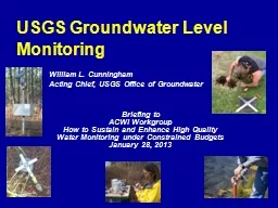
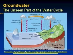
Dave Dilks Joyce Dunkin SRRTTF Technical Track Work Group August 3 2016 1 Purpose Update original May 2015 groundwater scoping analysis to estimate magnitude of groundwater PCB concentrations upgradient of Kaiser ID: 606359
Download Presentation The PPT/PDF document "Updated High Level Scoping for Groundwat..." is the property of its rightful owner. Permission is granted to download and print the materials on this web site for personal, non-commercial use only, and to display it on your personal computer provided you do not modify the materials and that you retain all copyright notices contained in the materials. By downloading content from our website, you accept the terms of this agreement.
Slide1
Updated High Level Scoping for Groundwater Contamination Up-gradient of Kaiser
Dave Dilks, Joyce Dunkin SRRTTF Technical Track Work GroupAugust 3, 2016
1Slide2
Purpose
Update original May 2015 groundwater scoping analysis to estimate magnitude of groundwater PCB concentrations up-gradient of KaiserConsider data from additional background wells
Revise assumption for area of impact
2Slide3
Original Analysis
Simple mass loading analysis conducted to assessHow much load coming from Kaiser plume?How much load coming from Kaiser property contamination outside of Kaiser plume?Background load estimated from concentration observed at a single well
(
RM-MW-9s)
3Slide4
Original Background Well
Original Analysis
Kaiser Plume
Groundwater FlowSlide5
Update of Original Analysis
Background well used in original analysis located in close proximity to stormwater dry wellsMay not accurately represent background concentrationsAnalysis repeated using data from additional background wells
5Slide6
Background Wells Used In Update
MW5
MW10
MW11
MW4
North Supply Well
MW5s
Background Wells Used In Update
Groundwater FlowSlide7
MW5
MW15
MW10
MW11
MW4
North Supply Well
MW5s
Background
Wells
Casting Area Wells
River Area Wells
How Can We Tell What Is Background?
Groundwater FlowSlide8
Groundwater Mass Loading Model*
Calculates PCB loading based upon calculated seepage rate and specified concentration
Model inputs include
8
Hydraulic conductivity
Horizontal groundwater gradient
Horizontal length of impacted zone
Vertical length of bank seepage face
PCB
concentration in groundwater
*Model and key assumptions provided on SRRTTF web siteSlide9
Updated Calculations
Identical model framework used as from original analysisTwo inputs updated from original calculations
9
Hydraulic conductivity
Horizontal groundwater gradient
Horizontal length of impacted zone
Vertical length of bank seepage face
PCB
concentration in groundwaterSlide10
Updated Background Concentration
Options consideredWhich well(s) to use?MW-5Average of all wellsBoth options result in avg
.
concentration of 380
pg/lConsideration of variability
“Spikes” observed in most wells
Analysis repeated using median value of 100
pg
/l
10Slide11
Updated Seepage Face
Over what length do the background concentrations enter the river?1.1 mile seepage face (---
)assumed, based on:
Background signal seen at wells MW-15 and MW-5
No PCBs seen at Sullivan Park
11Slide12
Estimated Up-Gradient Loading
Up-gradient load estimated at 14 to 55 mg/day
55
mg/day if average well concentration data is assumed
14 mg/day if spikes are dismissed
2015 synoptic survey data may lend some credence to spikes
12Slide13
River Data May Lend Credence to Spikes
2015 Mirabeau Park river station located just upstream of Kaiser also show a spike in PCBsOriginally considered an outlier, but maybe not
13Slide14
Homologue Pattern Not Too Dissimilar to Background Wells
Difficult to say too much with a single (relatively low concentration) river sample, but worth investigating Up-gradient Groundwater River Spike Kaiser Plume
14Slide15
River Data May Lend Credence to Spikes
Mass balance analysis with consideration of “outlier” gives results consistent with above analyses
15Slide16
Conclusions
Analysis is not rigorous enough to “prove” that a significant up-gradient source exists
Rigorous enough to show that
up-gradient
sources merit additional consideration
40 to 55 mg/day load, if accurate, corresponds to one of the largest sources of loading to the river
More difficult questions
Who is responsible?
How feasible is it to remediate?
16