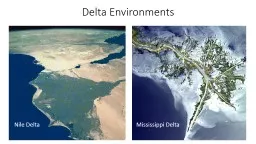
/
Recent Vegetations Biodiversity in Nile Delta Wetlands in E Recent Vegetations Biodiversity in Nile Delta Wetlands in E

Recent Vegetations Biodiversity in Nile Delta Wetlands in E - PowerPoint Presentation

mitsue-stanley
mitsue-stanley . @mitsue-stanley
Follow
374 views
Uploaded On 2016-05-08

Recent Vegetations Biodiversity in Nile Delta Wetlands in E - PPT Presentation

Mary G Ghobrial Professor of Aquatic Plants National Institute of Oceanography amp Fisheries Kayet bay Alexandria Egypt 3 rd International Conference on Earth Science amp Climate Change ID: 310360

average range lake water range average water lake µg 2012 climate pollution mediterranean important change diversity wetlands 2013 potamogeton

Share:

Link:

Embed:

Download Presentation from below link

Download Presentation The PPT/PDF document "Recent Vegetations Biodiversity in Nile ..." is the property of its rightful owner. Permission is granted to download and print the materials on this web site for personal, non-commercial use only, and to display it on your personal computer provided you do not modify the materials and that you retain all copyright notices contained in the materials. By downloading content from our website, you accept the terms of this agreement.


Presentation Transcript

Slide1

Recent Vegetations Biodiversity in Nile Delta Wetlands in Egypt

Mary G. GhobrialProfessor of Aquatic PlantsNational Institute of Oceanography & FisheriesKayet-bay, Alexandria, Egypt

3

rd

International Conference on

Earth Science & Climate ChangeSlide2

Aquatic plantsIntroduction Aquatic plants are an integral part of a lake and its aging process. Many of the threats to fresh waters such as, climate change and eutrophication will result in reduced macrophyte diversity and will, in turn, threaten the faunal diversity of aquatic ecosystems and favour the establishment of exotic species, at the expense of native species.Slide3

Wetlands and global climate changeAccording to the International Panel on Climate Change (IPCC) and other researchers, Wetlands cover 6% of the world’s land surface and contain about 12% of the global carbon pool. Due to this fact, wetlands are playing an important role in the global carbon cycle (IPCC 1998 and Ferrati et al. 2005).Several problems affect the environment of the Nile Delta lakes such as: Climate change, pollution, land reclamation, intensive aquatic vegetation, over fishing, and

eutrophication. Examples of impacts resulting from projected changes in extreme climate events (STRP Ramsar2002) include; decreased water resource quantity and quality; increased coastal erosion Slide4

Over 25% of all the Mediterranean wetlands are found along the Mediterranean Coast of Egypt. Slide5

1. Lake Maryut Located on the north Mediterranean coastOne of the smallest and most polluted lakes in EgyptLatitude/longitude:31°09′11″N 29°53′54″E, Altitude: -13 mCovers an area of 65 km2Divided into 5 basins

Problems• Decreased lake area over time• Significant decrease of fish production•Continuous negative impacts (Agricultural, untreated industrial and domestic wastes)Slide6
Slide7

Lake Maryut basins are recharged with agricultural drainage water via a number of drains most important of which are the Omom Drain, Nubaryia Drain, West Nubaryia Drain and Al-Qalaa Drain. These drains carry agricultural drainage water resulting from the irrigation of an area of 450000 feddans of cultivated lands located south of Alexandria which contains high concentrations of various chemical fertilizers and pesticides, as well as sanitary and industrial water drainage as shown in Table 1 (Gaballah.et al. 2005, ALAMIM, 2009, Alexandria Lake

Maryut Integrated Management ALAMIM Project)The Environmental Problems of Lake Maryut could be summarized as follows: 1- Severe decrease in the concentration of dissolved oxygen; 2-An increase in the density of water plant growth (green canopy) ; 3- Presence of organic pollutants (agricultural pesticides and industrial wastes; 4-Expected direct impact on ecosystem and biodiversity.Slide8
Slide9

Hydro chemical parametersWater temperature: average 24 ˚C, range 14 – 30.5 ˚CWater transparency: average 64.75 cm, range 0 – 250 cmSalinity: average 3.68 ‰, range 1.65 – 6.86 ‰ (total dissolved salts)pH: average 8.24, range 7.46 – 8.75DO: average 5.82 mg/l, range 0 – 14.22 mg/lBOD: average 52.18 mg/l, range 2.94 – 729 mg/lCOD: average 151.30 mg/l, range 42.67 – 512 mg/l

NutrientsNH4-N: average 2.24 mg/l, range 0.03 – 15.89 mg/lNO2-N: average 78.40 µg/l, range 0.71 – 420.89 µg/lNO3-N : average 0.27 mg/l, range 0.007 – 1.01 mg/lPO4-P : average 417.90 µg/l, range 2.54 – 2517.74 µg/lSlide10

Aquatic vegetations during 2012-2013Aquatic macrophytes recorded in summer and autumn 2012, winter and spring 2013, were low diversity, indicating continuous pollution hazards. Therefore, macrophytes water pollution indicators were present, such as; Eichhornia crassipes and Potamogeton and Ceratophyllum, particularly in the main basin and Southwest basin too.

Main Basin Eichhornia crassipes Ceratophyllum demersum Potamogeton pectinatusSlide11

At station 6, which is known for the abundance of submerged vegetations, a new submerged macrophyte, P. pusillus, was recorded for the first time in Lake Maryout along the project period, 2009-2013

Potamogeton pusillus L. small pondweedSlide12

Northwest Basin Other vegetations

Phragmites australis, common reed Spreading on lake borders and show patches inside lake basins Cabomba caroliniana Pistia stratiotes

Chara

tomentosum

Najas

flexilis

P.

australis

and water hyacinths Slide13

It is considered to be a lake and wetland site of International importance for birds under the Ramsar Convention.Burullus extends along the northern fringe of the Nile Delta at latitude 31°22'-31°35'N and longitude 31°31'-32°08'E. Lake Burullus is a shallow brackish lake extending for 47 km along the deltaic Mediterranean coast of Egypt.

The lake’s area decreased from 502.7 km2 in 1984 to 410 km2 in 1997 (its length decreased from 56 to 47 km, while the width decreased from 15 to 14 km). The water depth reaches 200 cm in the middle and near the sea outlet (Bughaz El-Burullus).According to the map of the world distribution of arid regions (UNESCO 1977), the northern Mediterranean part of the Nile Delta belongs to the arid region. The climatic conditions are warm summers (20–30C) and mild winters (10–20C).Lake BurullusSlide14
Slide15

Hydrochemical parametersWater temperatures: average 22.37 ˚C, range 15.5 – 29.20 ˚CWater transparency: average 23.44 cm, range 10 – 60 cmWater salinity: average 3.62 ‰, range 0.60 – 15.01 ‰DO: average 8.37 mg/l, range 1.73 – 17.70 mg/lBOD: average 18.09 mg/l, range 0.42 – 72.90 mg/lCOD: average 165.03 mg/l, range 20.16 – 531.30 mg/lNutrients

NH4-N: average 0.67 mg/l, range 0.011 – 1.74 mg/lNO2-N: average 104.44 µg/l, range 3.18 – 564.3 µg/lNO3-N: average 0.20 mg/l, range 0.013 - 0.933 mg/lPO4-P: average 178.64 mg/l, range 11.85 – 932.62 mg/lSlide16

The results of summer-autumn seasons 2012, and winter-spring 2013 at Lake Burullus, indicated the disappearance of macrophytes diversity that is characterizing international Ramsar sites wetlands list.Station 5, known to be far from pollution sources, the pollution indicator species dominated (P. pectinatus and Ceratophyllum

demersum) in summer 2012.The submerged Myriophyllum spicatum (north of Burullus)

Myriophyllum

spicatum

L.

Potamogeton

pusillus

L.

Eichhornia

crassipes

Slide17

Lake Edku is a coastal lagoon in the eastern Mediterranean and is located about 40 Km eastern of Alexandria and 18 Km western of Rosetta branch of the River Nile in Egypt.Area: 62.78 million square meterThe lake is connected to the adjacent Abu Qir Bay through Boughaz El Maadiyalongitudes 30° 8' E and latitudes 31°10 ' N.

Lake Edku has been exposed to different sources of pollution, the agriculture drainage, untreated industrial wastes, untreated wastes of several factories (EEAA, 2000) and the aggregated boats at Boughaz El- Meaddya (i.e. the entrance of the lake) would release the oil wastes and other discharges.Lake EdkuSlide18
Slide19

Hydrochemical parametersWater temperature: average 22.69 ˚C, range 14.0 – 30.8 ˚CWater transparency: average 26.76 cm, range 15 – 75 cmWater salinity: average 1.50 gm/l, range < 0.77 – 3.28 gm/lpH: average 8.47 , range 7.61 – 9.11DO: average 7.26 mg/l, range 0.93 – 14.31 mg/lBOD: average 20.71 mg/l, range 5.94 – 58.32 mg/lCOD: average 181.21 mg/l, range 32.0 – 759.80 mg/l

NutirentNH4-N: average 0.70 mg/l, range 0.02 – 3.09 mg/lNO2-N: average 136.9 µg/l, range 2.47 – 472.22 µg/lNO3-N: average 0.22 mg/l, range 0.43 – 10.33 mg/lPO4-P: average 323.14 µg/l, range 8.46 – 1078.19 µg/lSlide20

Stations situated in front of fish aquaculture drainage water, Phragmites was recordedThe three forms of aquatic macrophytes were shown in front of fish aquacultures drainage water, along the period of investigation 2012-2013, , such as free-floating (water hyacinths); submerged (Potamogeton and Ceratophyllum demersum and Cabomba

caroliniana) and emergent (Scirpus maritimus), which is known to resist salinity changes). At the deepest place in the lake, macrophytes diversity was very poor and Potamogeton, Ceratophyllum and water hyacinths were recorded along the 4 seasons 2012-2013.In front of El-Khairy Drain, the emergent Polygonum amphibium was recorded in autumn 2012.Generally the macrophytes diversity was very poor, due to wastewater discarding, without any treatment.

Polygonum

amphibium

L., water smartweedSlide21

Lake ManzalaLake Manzala, the largest (60 km long and 40 km wide) of Egypt's Mediterranean wetlands and the most productive for fisheries.Latitude : 31° 15' 44" N, Longitude 32° 11' 33" E It is bounded by the Mediterranean Sea at the north, Suez Canal at the east There are over 1000 islands scattered throughout the lake and fish farms take up large areas of its northwest

This huge shallow lake is suffering from land reclamation, industrial and nutrient pollution, and overgrowth by water hyacinth.Formerly saline or brackish, its salinity is reduced by year-round freshwater inflow and poor drainage to the sea, and fish catches are reduced.Extensive emergent reed beds, mainly of Phragmites, help to localise pollution, but also prevent the circulation of saline water.Slide22
Slide23

Hydro chemical ParametrsWater Temperature: average 22.97, range 15.30 – 29.50 ˚CWater transparency: average 45.84 cm, range 10 – 125 cmWater salinity: average 22.55 g/l, range 1.44 – 10.44 g/lpH: average 8.21, range 7.07 – 8.93DO: average 5.20 mg/l, range 0 – 9.72 mg/lBOD: average 45.11 mg/l, range 2.43 – 279.45 mg/l

COD: average 134.08 mg/l, range 13.94 – 640.00 mg/lNutrientsNH4-N: average 1.29 mg/l, range 0.02 – 12.30 mg/lNO2-N: average 82.52 µg/l range 1.41 – 563.77 µg/l NO3-N: average 0.15 mg/l, range 0.006 – 0.91 mg/lPO4-P: average 173.73 mg/l range 3.05 – 917.39 mg/lSlide24

Spring 2013

In front of Bahr-ElBakar and Hadous Drains, water hyacinths dominated. At station 5 (partly away from direct pollution source) Potamogeton pectinatus and P.

crispus

were show. The stations known for the plenty of submerged vegetations, were very poor with the presence of only pollution indicators, such as P.

pectinatus

and

Ceratophyllum

demersum

.

In front of El-

Serou

and

Faraskour

drains, submerged vegetations prevailed;

P

.

pectinatus

,

Najas

marina

and

Echinochloa

stagnina

, these stations are considered poorest as they are known for the plenty of

submergents

also.

Echinochloa

stagnina

Potamogeton

crispus

Najas

marina Slide25

Lake BardawilLake Bardawil is about 90 kilometers long, and 22 kilometers wide. It covers an area of about 700 km

2.Latitude 31° 08' 37" N, longitude 33° 13' 58" EThe extremely saline Lake Bardawil is an important feature of the north coast of Sinai and stretches along much of its length. It is considered the least polluted of all Delta Lakes. Since this lake is registered in the Ramsar site of internationally important wetland, it is recommended.The lake is a shallow basin, separated from the Mediterranean by a low sandbar that is between 100m and 1km wide and is often covered by seawater. The sandy bottom of this shallow lake (0.5-3.0m) is covered by patches of the ditch grass, Ruppia spiralis

and there is a number of islands. Lake

Bardawil

is important for its fishery of up to 2500 tones annually.Slide26
Slide27

Hydrochemical parametersWater temperature: average 24.03 ˚C, range 17 – 32 ˚CWater transparency: lake water is transparent allover the yearWater salinity: average 46.36 g/l, range 38.11 – 63.32 g/lpH: average 8.32, range 7.83 – 9.01DO: average 5.83 mg/l, range 3.25 – 8.34 mg/lBOD: average 0.99 mg/l, range 0.16 – 2.70 mg/lCOD: average 12.91 mg/l, range 7.97 – 23.28 mg/l

NutrientsNH4-N: average 0.022 mg/l, range 0.004 – 0.138 mg/lNO2-N: average 1.84 µg/l, range 0.26 – 6.384 µg/lNO3-N: average 0.020 mg/l, range 0.003 – 0.041 mg/lPO4-P: average 5.37 µg/l, range 0.38 – 32.09 µg/lSlide28

The green macroalga Caulerpa taxifolia was recorded at El-Zaranik station, for the first time in Lake Bardawil history, in summer and autumn 2012.

The eelgrass Zostera marina, Cymodocea nodosa, Ruppia cirrhosa and Posidonia oceanica are native at Bardawil, could be found all year round.The green macroalga Caulerpa prolifera was dominant along one year investigation 2012-2013.Ulva and two species of green macroalgae Enteromorpha; E.

intestinalis

and

E

.

flexuosa

recorded for the first time

In spring 2013, the

brown

macroalga

Colpomenia

, which is traced for the first time in

Bardawil

and also the

red

macroalga

Hypnea

, recorded for the first time too at station5. Probably all the

macroalgae

have entered to the lake through the

Boughaz

.

The diversity in 2010 – 2011 was much more diverse than the current 2012 - 2013Slide29

Zostera marina (eelgrass

Cymodocea nodosa

Caulerpa

prolifera

Enteromorpha

intestinalis

Caulerpa

tao

xif

liaSlide30

ActivitiesAn important management strategy to ensure wetland sustainability is the

prevention or reduction of additional stress that can reduce the ability of wetlands to respond to climate change. Maintaining hydrology, reducing pollution, controlling vegetation, and protecting wetland biological diversity and integrity are important activities to maintain and improve the resiliency of wetland ecosystems so that they continue to provide important services under changed climatic conditions (Kusler et al., 1999, Ferrati et al. 2005).Slide31

ProceduresThe research project in Nile Delta is very important and must be designed to solve the main problem (ecosystem degradation) and address the following activities.Conducting actual scenarios on the effect climate change on both the coastal areas and the Nile water

availability.Adopting different measures, such as water recycling, and exploitation of underground water resources to increase water productivity.Using of modern irrigation techniques and genetically modified seeds which grow with less water demands. Identifying new technology to be applied in water recycling which resulted in the reduction of freshwater discharge to the Mediterranean. Improving technical performance of water supply and deliver system. Slide32

7. Adopting different technologies for waterways, ponds, reservoirs and lakes restoration. 8. Reusing wastewater to support the agriculture production with minimal risks to the ecosystem.9. Integrating bio systems to produce more products and generate less waste.10. Groundwater and surface water bodies are physically interlinked; and need to be managed in an integrated way.11. Adopting modern farming technology to increase crop-water productivity and reduce pollutants.

12. Providing guidance with regard to crop production, water requirement and water quality.Slide33

ConclusionEnormous progress has been made in increasing our understanding of climate change, and a clearer picture of current and future impacts is emerging. Research is also shedding light on actions that might be taken to limit the magnitude of climate change and adapt to its impacts (DELS NRC, 2012).Wetland water systems are very vulnerable to climate change. Changes in quantity and quality of their water through alterations in hydrological regimes will definatly affect its habitat.

Restoration process will need to be realized differently on a regional level, making it important to recognize that specific restoration and management plans is required for each case (Kevin L. E., 2009).Slide34

Thank You

For Your Attention