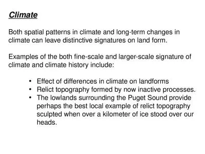
Precipitation for Aug 1 2011 through Mar 31 2012 Location Total Precip Departure From Historical inches Normal inches Rank Lamberton 535 ID: 700932
Download Presentation The PPT/PDF document "Climate Stations in Southwestern and sou..." is the property of its rightful owner. Permission is granted to download and print the materials on this web site for personal, non-commercial use only, and to display it on your personal computer provided you do not modify the materials and that you retain all copyright notices contained in the materials. By downloading content from our website, you accept the terms of this agreement.
Slide1
Climate Stations in Southwestern and south-central MN
Precipitation for Aug 1, 2011 through
Mar
31,
2012
Location Total
Precip
Departure From Historical
(inches) Normal (inches) Rank
Lamberton
5.35
-
8.50 1st
Pipestone
6.31
-
7.58 7th
Marshall
4.66
-
10.10 2nd
Lakefield
6.58
-
7.34 2nd
Windom
6.54
-
8.72 5th
Worthington
7.74
-
6.42 12th
St James
5.07 -9.72
3rd
Fairmont
7.80 -8.46
3rd
Benson 6.47
-8.23 2nd
Melrose
6.35
-
8.37 2nd
Jordan 8.31 -8.33 5th
Morris 6.59
-
6.89 8th
Milan 5.24 -8.09 1st
Waseca
8.65 -
10.87 2nd
Winnebago
7.97
-
8.53 1st
Austin 8.97 -8.11 9th
Zumbrota 8.86 -9.13 7th
Slide2
Ten Day Precipitation Anomaly (thru Apr
9th)Slide3
Apr Climate Outlook
Apr-June Climate OutlookSlide4
Summary
The drought threat posed by inadequate stored soil moisture across southern and western Minnesota is the most serious in over a
decade, perhaps for some counties since 1987.
Many areas are so deficient in stored soil moisture they will need
125 to 175 percent of normal rainfall (7.50 to 10.5 inches) during
April and May to make up the difference. February’s wetness was a good start, and March brought some highly variable amounts.
Historical
climate patterns show about a 1 in 4 (SC) to a 1 in 6 (WC) probability
that
April-May
precipitation would exceed
7.5
inches
in southern and western counties.
Analogous years where a
somewhat similar
situation
worsened
included
1974
, 1976,
and 1988.
Conversely analogous years when a
somewhat similar
situation was alleviated by either a wet spring and/or a wet summer included
1964
, 1968, 1977, and 1984.
Contingency planning for dealing with drought during 2012 is an exercise in judgment, but probably wise to do this year. Crop insurance options should be seriously considered where soil moisture deficiencies are
still
great.
Unfortunately minimal tillage may not be an option where large soil aggregates were left in the fall.Slide5
Top 20
wettest Apr-May
periods in
southwestern,
MN since 1895 based on pooled mean coop observers (in.)
1979 7.49 1937 7.64
2005 7.69
1984
7.79
1999 7.87 2004 7.89 1959 7.91 1991 7.971960 8.44 2000 8.49 2011 8.57 1985 8.61 1995 8.71 1972 8.75 1938 9.03 1986 9.17 1953 9.30 1993 9.33 1965 10.49 2001 11.06
TREND IN WET APRIL-MAY PERIODS FOR SOUTHWESTERN MN
11
of top 20 come from past 3 decadesSlide6
Climate Stations in Southwestern and south-central MN
Precipitation for Feb 1, 2012 through Feb 29, 2012
Location Total Precip Departure From Historical
(inches) Normal (inches) Rank Lamberton 1.73 +1.22 2ndPipestone 1.77 +1.17 5th
Marshall 1.91 +1.17 6th
Lakefield 2.19 +1.67 1st
Windom 2.08 +1.33 4th
Worthington* 2.23 +1.58 1
st
St Peter 2.01 +1.36 2ndFairmont 2.54 +1.74 5th Waseca 2.09 +1.09 10th Sioux Falls, SD 2.43 +1.80 3rdWinnebago 2.34 +1.57 5thFaribault* 2.55 +1.78 1st A Good Start, But Much More Rain Needed