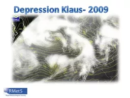
/
Depression Klaus- 2009 Depression Klaus- 2009

Depression Klaus- 2009 - PowerPoint Presentation

myesha-ticknor
myesha-ticknor . @myesha-ticknor
Follow
388 views
Uploaded On 2015-11-14

Depression Klaus- 2009 - PPT Presentation

You will be able to describe the passage of depression Klaus over the 23 rd and 24 th of January Objectives You will be able to identify the different stages in the development of depression Klaus using satellite and temperature maps ID: 193384

conveyor january cold warm january conveyor warm cold depression cloud system area midnight intense klaus front identify air weather midday pressure wrapped

Share:

Link:

Embed:

Download Presentation from below link

Download Presentation The PPT/PDF document "Depression Klaus- 2009" is the property of its rightful owner. Permission is granted to download and print the materials on this web site for personal, non-commercial use only, and to display it on your personal computer provided you do not modify the materials and that you retain all copyright notices contained in the materials. By downloading content from our website, you accept the terms of this agreement.


Presentation Transcript

Slide1

Depression Klaus- 2009Slide2

You will be able to describe the passage of depression Klaus over the 23

rd and 24th of January.

Objectives

You will be able to identify the different stages in the development of depression Klaus using satellite and temperature maps.

You will be able to offer reasons for why depression Klaus was particularly intense compared to other storms.Slide3

Differences between polar and equatorial temperatures influence the power and strength of depressions. Weather systems help ‘

normalise these differences’. At the time of the depression there was a strong temperature gradient across the Atlantic.

Unusually for this depression it began further south than normal, therefore it was fed by warm and moist air from the Caribbean. Slide4

January 23

rd Midnight.

Old, decaying weather system over Iceland.

Isobars getting closer together

Cloud associated with the warm conveyor.

Developing ‘hook’ of cloud caused by the cold conveyor.Slide5

Band of warm air feeding the depression.

January 23

rd

Midnight

.Slide6

January 23

rd Midday.

Intense

area

of low pressure.

Cloud associated with the warm conveyor.

Cloud associated with the cold conveyor- wrapped around the low.Slide7

January 23

rd Midday.

Warm conveyor can be clearly seen.

Cold, polar air getting wrapped around behind the area of low pressure.Slide8

January 23

rd Seven p.m.

Intense

area

of rainfall as the warm front travels over the Bay of Biscay.Slide9

January 24

th Midnight

Intense depression- tightly packed isobars.

Warm conveyor belt has been cut off from the system.

Cold conveyor is now wrapped tightly around the system.Slide10

January 24

th Midnight

Warm conveyor belt has been cut off from the system by the hook of the cold conveyor.Slide11

January 24

th Midnight

Area of lowest pressure, show by the tightly packed isobars.

Cold front

Warm front

Occluded frontSlide12

January 24

th Midnight

Intense area of rainfall as the cold front travels over the Bay of Biscay.Slide13

January 24

th Six am

Rainfall begins to become less intense.Slide14

January 24

th Midday

Cloud associated with the cold conveyor is starting to decay.

Another weather system to the West begins to develop.Slide15

January 24

th Midday

Cold air associated with the previous system can be clearly seen over the UK, France and Germany.

New band of warm air, associated with the new weather system.Slide16

Can you?

Identify depression Klaus.

Identify the area of lowest pressure.

Identify the warm conveyor cloud.

Identify the cold conveyor cloud head.