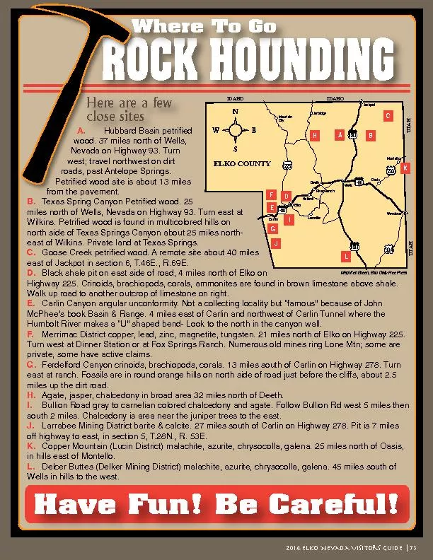
/
Hubbard Basin petrified wood. 37 miles north of Wells, Nevada on Highw Hubbard Basin petrified wood. 37 miles north of Wells, Nevada on Highw

Hubbard Basin petrified wood. 37 miles north of Wells, Nevada on Highw - PDF document

myesha-ticknor
myesha-ticknor . @myesha-ticknor
Follow
620 views
Uploaded On 2016-06-12

Hubbard Basin petrified wood. 37 miles north of Wells, Nevada on Highw - PPT Presentation

ROCK HOUNDING Where To Go Here are a few I80 US93 US93 I80 233 93A 225 Jarbidge MountainCity CarlinHalleck River Ranch LamoilleDeeth Oasis Wells Wendover MapKen Green Elko Daily Free Press UTAHUT ID: 359621

ROCK HOUNDING Where Go Here are

Share:

Link:

Embed:

Download Presentation from below link

Download Pdf The PPT/PDF document "Hubbard Basin petrified wood. 37 miles n..." is the property of its rightful owner. Permission is granted to download and print the materials on this web site for personal, non-commercial use only, and to display it on your personal computer provided you do not modify the materials and that you retain all copyright notices contained in the materials. By downloading content from our website, you accept the terms of this agreement.


Presentation Transcript

Hubbard Basin petrified wood. 37 miles north of Wells, Nevada on Highway 93. Turn roads, past Antelope Springs. Texas Spring Canyon Petrified wood. 25 miles north of Wells, Nevada on Highway 93. Turn east at north side of Texas Springs Canyon about 25 miles north-east of Wilkins. Private land at Texas Springs. Goose Creek petrified wood. A remote site about 40 miles east of Jackpot in section 6, T.46E., R.69E. Black shale pit on east side of road, 4 miles north of Elko on Walk up road to another outcrop of limestone on right. Carlin Canyon angular unconformity. Not a collecting locality but “famous” because of John McPhee’s book Basin & Range. 4 miles east of Carlin and northwest of Carlin Tunnel where the Merrimac District copper, lead, zinc, magnetite, tungsten. 21 miles north of Elko on Highway 225. Turn west at Dinner Station or at Fox Springs Ranch. Numerous old mines ring Lone Mtn; some are Ferdelford Canyon crinoids, brachiopods, corals. 13 miles south of Carlin on Highway 278. Turn east at ranch. Fossils are in round orange hills on north side of road just before the cliffs, about 2.5 Agate, jasper, chalcedony in broad area 32 miles north of Deeth. Bullion Road gray to carnelian colored chalcedony and agate. Follow Bullion Rd west 5 miles then Larrabee Mining District barite & calcite. 27 miles south of Carlin on Highway 278. Pit is 7 miles off highway to east, in section 5, T.28N., R. 53E. Copper Mountain (Lucin District) malachite, azurite, chrysocolla, galena. 25 miles north of Oasis, Delcer Buttes (Delker Mining District) malachite, azurite, chrysocolla, galena. 45 miles south of Wells in hills to the west. ROCK HOUNDING Where To Go Here are a few I-80 US93 US93 I-80 233 93A 225 Jarbidge MountainCity CarlinHalleck River Ranch LamoilleDeeth Oasis Wells Wendover Map/Ken Green, Elko Daily Free Press UTAHUTAH A B C D E F G H I J K L Have Fun! Be Careful! 2014 Elko Nevada Visitors Guide | 73