/
Regional Structure and Kinematic History of the Sevier fold and thrust belt, central Utah Regional Structure and Kinematic History of the Sevier fold and thrust belt, central Utah

Regional Structure and Kinematic History of the Sevier fold and thrust belt, central Utah - PowerPoint Presentation

olivia
olivia . @olivia
Follow
342 views
Uploaded On 2022-05-14

Regional Structure and Kinematic History of the Sevier fold and thrust belt, central Utah - PPT Presentation

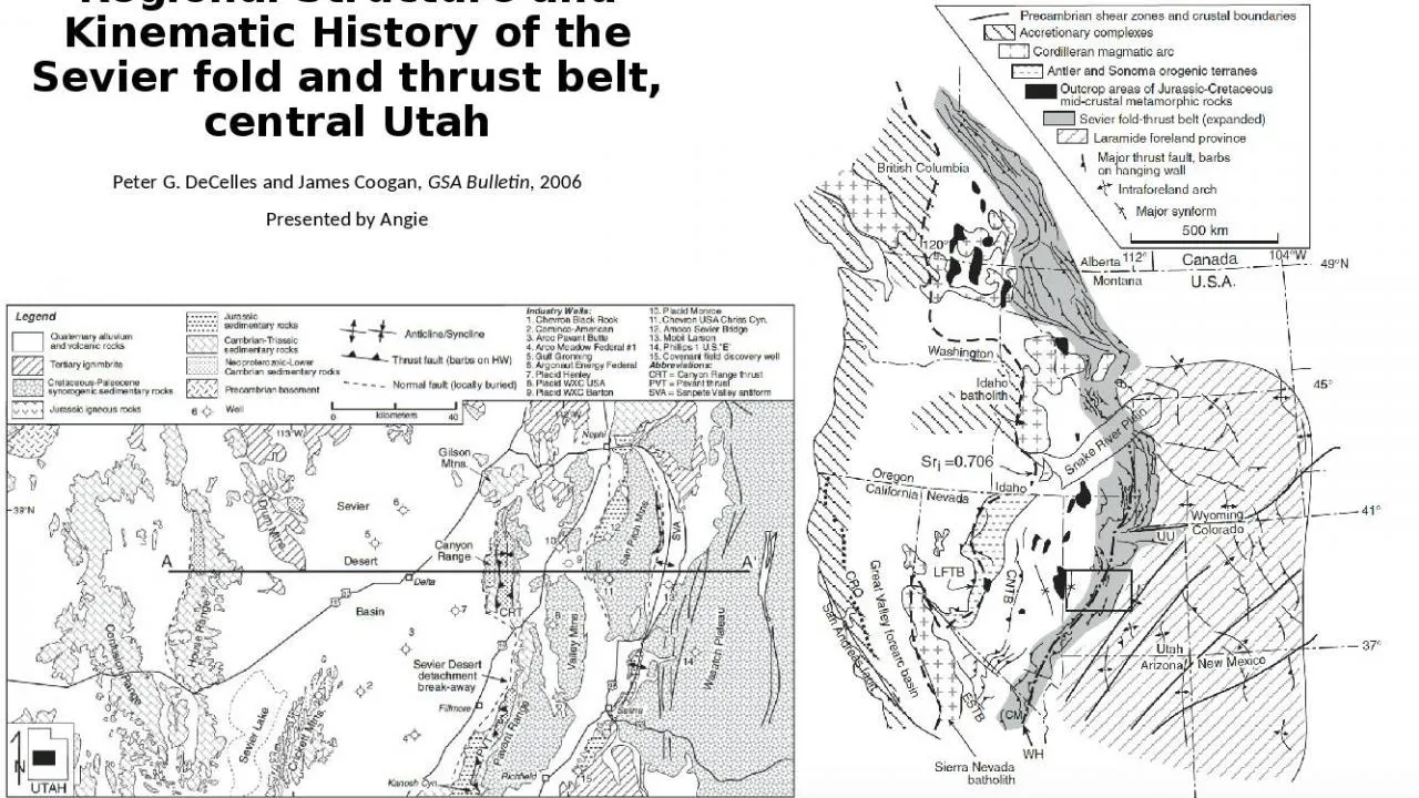
Peter G DeCelles and James Coogan GSA Bulletin 2006 Presented by Angie Tectonic Setting Sevier fold and thrust belt is a segment of the greater cordilleran retro arc thrust belt Formed along the western margin of north America in response to the subduction of oceanic plates subducti ID: 911180

cordilleran thrust sevier canyon thrust cordilleran canyon sevier belt range history thrusting crust east central data fold kinematic section

Share:

Link:

Embed:

Download Presentation from below link

Download Presentation The PPT/PDF document "Regional Structure and Kinematic History..." is the property of its rightful owner. Permission is granted to download and print the materials on this web site for personal, non-commercial use only, and to display it on your personal computer provided you do not modify the materials and that you retain all copyright notices contained in the materials. By downloading content from our website, you accept the terms of this agreement.


Presentation Transcript

Slide1

Regional Structure and Kinematic History of the Sevier fold and thrust belt, central Utah

Peter G. DeCelles and James Coogan, GSA Bulletin, 2006Presented by Angie

Slide2

Tectonic Setting

Sevier fold and thrust belt is a segment of the greater cordilleran retro arc thrust belt Formed along the western margin of north America in response to the subduction of oceanic plates, subduction rates increased after oceanic basin closureMajor features across the greater cordillera include the Sierra Nevada, the Luning- Fencemaker thrust belt, Golconda and Roberts Mountains allochthons, Sevier fold and thrust belt, Sevier desert basin

Slide3

Motivation

To provide a revised synthesis of data for the Sevier belt in the central Utah area. Results have implications for: The history of the Cordilleran foreland basinCrustal thickening and elevation gain estimates in the central part of the orogenic belt

The cordilleran magmatic arc history

Slide4

Stratigraphy

Slide5

Stratigraphy

West- Thick Offshore East - Thin Platformal Transition zone: Canyon range Wasatch plateauAbove Jurassic Section: Wedge top and foredeep fill of the Cordilleran foreland basin system derived directly from growing cordilleran orogenic belt

Major detachments: exposed in

shaly

units like the Pocatello Neoproterozoic formation, Cambrian shale, Triassic shale, middle Jurassic shale

Competent units: quartzites, carbonates, sandstones

Incompetent: arpen shale unit strongly influences the structural style

Slide6

Slide7

KeyStructures

N

S

Slide8

Key Structures

Canyon Range Thrust- folded into a north trending synformPavant thrust – east dipping thrust faultPVTi- pavant footwall imbricates mapped, based off of seismic profiles and wells drilled in the area total shortening for this area = 26km

PXT- doesn’t outcrop to surface, so not described in detail. However it is known bc of seismic and well data GT- doesn’t outcrop but is documented in industry boreholes and seismic profiles

Sevier culmination-antiformal structure defined by deformation patterns and broadly arched seismic reflectors.

Pavant

, Paxton, Gunnison are thought to root beneath culmination. Canyon ridge folded above culmination

Slide9

Stratigraphic Seperation

Stratigrpahic separation diagram- evidence for a low hanging wall ramp on a frontal foot wall rampNorth- Western section: thurst climbs from west to east 250K= low angle hanging wall rampSouth- Eastern section: thrust climbs from west to east 1km = high angle footwall ramp

North south- Central section: thrust climbs 1.5km = major north dipping ramp

Slide10

Canyon Range Conglomerate

Slide11

Canyon range conglomerate

Contains quartzites that have been dated to mid cretaceous ageContains growth structures that indicate it was deformed as it accumulated by slip on minor bedding plane detatchements in the hanging wall of the thrust Important new observation: it isn’t cut by the canyon range thrust in the east, rather conglomerate overlaps the thrust in a buttress unconformity

Slide12

Thrusting Event

Emplacement Constraint

Thrusting Event Duration

Canyon Range Thrusting

AFT ~140Ma

Syn-kinematic white mica

Ar

/

Ar

and FT ~140-143Ma

145-110 Ma

Pavant

Range Thrusting

Palynologically dated late Albian- Cenomanian San Pitch Formation conglomerated

Growth structures in canyon range conglomerate

110-86Ma

Paxton Thrusting

Angular unconformity seen in subsurface data

86-75Ma

Gunnison Thrusting

Coeval development of Axhandle

wedgetop

basin at surface

75-65Ma

Slide13

Kinematic History

Slide14

Kinematic History

CRT-PVT-

PVTimbricates

-PXT-GT

Slide15

Implications

The history of the Cordilleran foreland basinFrom kinematic reconstruction data, data suggests a 250 km wide Nevadaplano sandwiched between Luning Fencemaker and Sevier fold and thrust belts

Crustal thickening and elevation gain estimates in the central part of the orogenic beltTotal shortening from reconstructions = 220km, 164Km at 90MaForward Propagation at 90 Ma = 300km

Flexural Wave Migration at 90Ma (164km+300km)= 464 km

Cordilleran Magmatic History

Equal amounts of displacement in upper crust and lower crust due to thrusting

Underthrust crust went westward where it melted and produced granitic magmas

Slide16

Conclusions

Type section of the Sevier fold and thrust beltShortening = 220km totalEarly Cretaceous – MaastrichtianFour major faultsWestern Faults- thicker units, longer distances. Eastern Faults- thinner units, shorter and more compactCrustal thickening suggests

Nevadaplano in the hinterlandAssuming equal amounts of displacement in upper and lower crust, lower crust underthrust to the west could correspond to the cordilleran magmatic arc root.