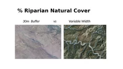
PPT-Comparing Vegetation in a Riparian Zone to an Upland Area i

Author : pamella-moone | Published Date : 2016-08-06

By Abby Branson Vegetation Ecology Summer 2013 Mountain Research Station University of Colorado Boulder Introduction Background Riparian Area An area that has high

Presentation Embed Code

Download Presentation

Download Presentation The PPT/PDF document "Comparing Vegetation in a Riparian Zone ..." is the property of its rightful owner. Permission is granted to download and print the materials on this website for personal, non-commercial use only, and to display it on your personal computer provided you do not modify the materials and that you retain all copyright notices contained in the materials. By downloading content from our website, you accept the terms of this agreement.

Comparing Vegetation in a Riparian Zone to an Upland Area i: Transcript


By Abby Branson Vegetation Ecology Summer 2013 Mountain Research Station University of Colorado Boulder Introduction Background Riparian Area An area that has high water content in the soil due to the presence of a water source ex lake stream glacier . Bui Ba Bong. FAORAP. The Second External Rice Advisory Group (. ERAG. ) Consultation on the Formulation of a Rice Strategy for Asia.  . Bangkok, Thailand, 28-29. th. November 2013.  .  . Region. Area . Niwot’s. Riparian Tundra. Sean Race. Vegetation Ecology – Semester B 2014. Mountain Research Station. UC-B. Introduction. Question: Does proximity of riparian area in alpine tundra affect the composition of the vegetation found there? . Vegetation and More. What is “riparian vegetation”?. Plants growing on the streambank and adjoining floodplain. Plants in this area are influenced by the water from the stream. Riparian Zone. Riparian Vegetation Functions. Riparian Degradation and Restoration. Ian McBride. Earth and Physical Science Department. Western Oregon University. Monmouth, Oregon. Email: imcbride11@wou.edu. Outline. Part 1: . I. ntroduction to Riparian Zones. Katie Ross-Smith, PhD. SFS – 2016 Annual Meeting. Development of Environmental Flows for Riparian Systems. Example from a recent hydroelectric project. Response of Riparian Systems to New . Flows. Examples from two monitoring projects. Region II. Agenda. Background, history, and intent. Types of riparian standards. Riparian areas by landowner. Allowed uses in riparian areas. Other riparian area BMPs. Variations from riparian standards. Region III. Agenda. Background, history, and intent. Types of riparian standards. Riparian areas by landowner. Allowed uses in riparian areas. Other riparian area BMPs. Variations from riparian standards. Several . Object Based Image Analysis Platforms. Troy Wirth. MGIS . Capstone Project . Proposal. Advisor: Dr. Douglas . Miller. Thanks to: Cheryl . Hummon. . (ODA), John Byers (ODA), Meta Loftsgaarden (OWEB). Abstract: Dryland river basins frequently support both irrigated agriculture and riparian vegetation and remote sensing methods are needed to monitor water use by both crops and natural vegetation in irrigation districts. We developed an algorithm for estimating actual evapotranspiration ( Ken Sargent . Three Parameter System. Hydrology . Soils. Vegetation. Checking for False Positives . Ideally All 3 . criteria (hydrology, soils and vegetation) would . change . together if . they are accurate indicators of the wetland boundary.. Ken Sargent . Three Parameter System. Hydrology . Soils. Vegetation. Checking for False Positives . Ideally All 3 . criteria (hydrology, soils and vegetation) would . change . together if . they are accurate indicators of the wetland boundary.. 1 Zone 1 is the 0 30 feet area directly around your homeZone 2 is the 30 100 feetarea outside of Zone 1 that surrounds your home There are different rules within each zone Your inspection form organiz Ian McBride. Earth and Physical Science Department. Western Oregon University. Monmouth, Oregon. Email: imcbride11@wou.edu. Outline. Part 1: . I. ntroduction to Riparian Zones. The pieces of a riparian zone. the Carolina Vegetation Survey . Protocol. M. Forbes Boyle, Robert K. Peet, Thomas R. Wentworth, and Michael Lee. 17 November 2010. The CVS Team. Project Directors. Robert Peet, UNC Chapel Hill. Thomas Wentworth, NC State University.

Download Document

Here is the link to download the presentation.
"Comparing Vegetation in a Riparian Zone to an Upland Area i"The content belongs to its owner. You may download and print it for personal use, without modification, and keep all copyright notices. By downloading, you agree to these terms.

Related Documents