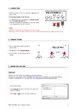
/
SSUSI and SSUSI-Lite SSUSI and SSUSI-Lite

SSUSI and SSUSI-Lite - PowerPoint Presentation

pamella-moone
pamella-moone . @pamella-moone
Follow
414 views
Uploaded On 2016-07-08

SSUSI and SSUSI-Lite - PPT Presentation

Special Sensor Ultraviolet Spectrographic Imager on DMSP and Beyond Dr Larry J Paxton SSUSI Principal Investigator and Head of Geospace and Earth Science Group Bob Schaefer John Hicks Yongliang ID: 396312

ena ssusi precipitation space ssusi ena space precipitation ionospheric ion weather information lbhl lite form solar operational rate ionosphere

Share:

Link:

Embed:

Download Presentation from below link

Download Presentation The PPT/PDF document "SSUSI and SSUSI-Lite" is the property of its rightful owner. Permission is granted to download and print the materials on this web site for personal, non-commercial use only, and to display it on your personal computer provided you do not modify the materials and that you retain all copyright notices contained in the materials. By downloading content from our website, you accept the terms of this agreement.


Presentation Transcript

Slide1

SSUSI and SSUSI-LiteSpecial Sensor Ultraviolet Spectrographic Imager on DMSP and Beyond

Dr. Larry J. PaxtonSSUSI Principal Investigator and Head of Geospace and Earth Science GroupBob Schaefer, John Hicks, Yongliang Zhang, Ethan Miller, Bernie Ogorzalek, Brian Wolven, Guiseppe Romeo and the SSUSI Team

SEASONS ConferenceSlide2

What is Space Weather?Slide3

Solar radiation Chain

Solar Wind/Magnetospheric Chain

Solar Energetic Particle Chain

Lower Atmospheric ChainSlide4

What is Space Weather?Slide5

What is Space Weather?

Space weather is the departure of the space environment from the average or climatological mean.There may be seasonal or longer term variations in the average conditions (e.g. solar cycle or seasonal effects).These variations have impacts on human systems.Establishing global climatology and the variations about those mean conditions enables us to design a cost-effective, robust system.

We must combine “good enough” scientific understanding with appropriate technology to produce a useful solution.Slide6

Nearly all C4ISR activities involving RF and space assets (or targets) are susceptible to ionospheric space weather effects to varying degrees.Many effects consitute

small risk factors, analogous to wind impacts on aircraft fuel burn, that may impact mission success. However, even apparently minor irregularities of the ionosphere may have severe impact on casualties, order of battle, and OUTCOMES: e.g., Takur-Ghar.Ionospheric effectsRefraction (bending) introduces position error in Doppler or single-site location, over-the-horizon radar techniques. Delays introduce ranging errors.Irregularities blind or dazzle radars with clutter, scramble nav/com signals (“scintillations”)

.

Ionosphere Impacts on C4ISR

Regions of scintillation, radar clutterSlide7

Space Capability Joint Effect

Environmental Cause

Environmental Effects

Potential Warfighter Impacts

Precision Engagement

Ionospheric scintillation, ionospheric refraction

Degraded GPS (or alternative navigation) system performance

GPS guided weapons miss target, increased collateral damage/civilian casualties

Intelligence

Aurora, upper atmospheric density change, ionospheric refraction and scintillation

Decreased intelligence system performance

Inaccurate enemy position data

Spacecraft anomaly assessment

Solar/Magnetospheric particle radiation,

Upper atmospheric density change, ionospheric refraction and scintillation

Satellite system anomalies, increased operational downtime of space system

Decreased operational space system utility (GPS, Space-Base Infra-Red System (SBIRS), Space Radar (SR), etc.)

Attack Assessment

Solar/Magnetosphere particle radiation,

auroral, upper atmospheric and ionospheric changes

Enemy and friendly weapon system performance degradation

Inability to meet attack assessment timelines, inability to distinguish hostile attack from natural effects

SSUSI Environmental Data Records shown in RED

SSUSI

can Help

Operators Distinguish Environmental from Deliberate EffectsSlide8

SSUSI can Help Operators Distinguish Environmental from Deliberate Effects

Space Capability Joint Effect

Environmental Cause

Environmental Effects

Potential Warfighter Impacts

Comms

on the Move

Ionospheric scintillation, ionospheric refraction

Degraded/broken communication link, anomalous radio wave propagation

Loss of command and control, lives/missions at risk

Space

situational

awareness

Upper atmospheric density change, ionospheric refraction and scintillation

Inaccurate space object identification and tracking

Space object collision (e.g. shuttle), inaccurate enemy space force position

Missile Warhead Detection/ Tracking/ Intercept

Aurora, upper atmospheric density change, ionospheric refraction and scintillation

, clouds, atmospheric attenuation

Degraded warhead detection and tracking

Decreased probability of missile intercept, lives at risk

SSUSI Environmental Data Records shown in REDSlide9

SSUSI Heritage and Relationship to Other ProgramsSlide10

SSUSI Heritage and Relationship to Other ProgramsSlide11

FUV Spectral Region Exhibits the Signatures of Space Weather

HI (121.6 nm)

OI (130.4 nm)

OI (135.6 nm)

N

2

(LBHs)

N

2

(LBHl)

Dayside Limb

H profiles and escape rate

1

Amount of O

2

absorption

1

O altitude profile

Amount of O

2

as seen in absorption

N

2

, Temperature

Dayside Disk

Column HAmount of O2 absorption1 Used with LBHs to form O/N2N2, Solar EUVSolar EUVNightside Limb

H profile and escape rateIon/ENA precipitation

EDP

HmF2

NmF2

T

plasma

Ion/ENA precipitation characteristic energy

Ion/ENA precipitation characteristic energy

Nightside Disk

Geocorna and

Ion/ENA precipitation

Ion/ENA precipitation

ò

n

e

2

ds (line of sight) and

ò

n

e

dz (vertical TEC)

Ion/ENA precipitation

Ion/ENA precipitation

Ion/ENA precipitation

Auroral

Zone

Region of proton precipitation

Auroral Boundary and amount of column O

2

present

1

Region of electron and (possibly) proton precipitation

Used with

LBHl

to form

Eo

and the ionization rate and conductance

information

Hemispheric power

Radar clutter

Charging

Measure of the effective precipitating flux, used with

LBHl

to form

Eo

and the ionization rate and conductance informationSlide12

FUV Spectral Region Exhibits the Signatures of Space Weather

HI (121.6 nm)

OI (130.4 nm)

OI (135.6 nm)

N

2

(LBHs)

N

2

(LBHl)

Dayside Limb

H profiles and escape rate

1

Amount of O

2

absorption

1

O altitude profile

Amount of O

2

as seen in absorption

N

2

, Temperature

Dayside Disk

Column HAmount of O2 absorption1 Used with LBHs to form O/N2N2, Solar EUVSolar EUVNightside Limb

H profile and escape rateIon/ENA precipitation

EDP

HmF2

NmF2

T

plasma

Ion/ENA precipitation characteristic energy

Ion/ENA precipitation characteristic energy

Nightside Disk

Geocorna and

Ion/ENA precipitation

Ion/ENA precipitation

ò

ne2ds (line of sight) and ònedz (vertical TEC)Ion/ENA precipitationIon/ENA precipitationIon/ENA precipitationAuroral ZoneRegion of proton precipitationAuroral Boundary and amount of column O2 present1Region of electron and (possibly) proton precipitationUsed with LBHl to form Eo and the ionization rate and conductance informationHemispheric powerRadar clutterChargingMeasure of the effective precipitating flux, used with LBHl to form Eo and the ionization rate and conductance informationSlide13

FUV Spectral Region Exhibits the Signatures of Space Weather

HI (121.6 nm)

OI (130.4 nm)

OI (135.6 nm)

N

2

(LBHs)

N

2

(LBHl)

Dayside Limb

H profiles and escape rate

1

Amount of O

2

absorption

1

O altitude profile

Amount of O

2

as seen in absorption

N

2

, Temperature

Dayside Disk

Column HAmount of O2 absorption1 Used with LBHs to form O/N2N2, Solar EUVSolar EUVNightside Limb

H profile and escape rateIon/ENA precipitation

EDP

HmF2

NmF2

T

plasma

Ion/ENA precipitation characteristic energy

Ion/ENA precipitation characteristic energy

Nightside Disk

Geocorna and

Ion/ENA precipitation

Ion/ENA precipitation

ò

ne2ds (line of sight) and ònedz (vertical TEC)Ion/ENA precipitationIon/ENA precipitationIon/ENA precipitationAuroral ZoneRegion of proton precipitationAuroral Boundary and amount of column O2 present1Region of electron and (possibly) proton precipitationUsed with LBHl to form Eo and the ionization rate and conductance informationHemispheric powerRadar clutterChargingMeasure of the effective precipitating flux, used with LBHl to form Eo and the ionization rate and conductance informationSlide14

APL Combines Heritage, Science, Engineering and Dual-Use TechnologyIn 1990, SSUSI started out as an

experiment on DMSP Block 5D3 (F16-F20). After development of the space weather mission, SSUSI is on the path to operational use.SSUSI/SSUSI-Lite team understands scientific principles and operational effects.Over time, the sensor role changed from an instrument that took auroral images to a scientific instrument capable of providing

Auroral

images

Auroral

energy inputs

Auroral ionospheric productsIonospheric imagesIonospheric bubble mapsNeutral atmosphere compositionHigh energy particle precip

. mapsMagnetic field maps for s/c chargingInputs to operational modelsWe continue to develop new productsMust go beyond “science” to products that directly support decisions and planning.Slide15

SSUSI has a Unique Ability: 3D Imaging of the IonosphereSSUSI scan pattern enables us to recover a 3D image of the ionosphere from the horizon-to-horizon + limb scan information.

About 100,000 line of sight TEC measurement per da per SSUSISlide16

SSUSI has a Unique Ability: 3D Imaging of the IonosphereSSUSI scan pattern enables us to recover a 3D image of the ionosphere from the horizon-to-horizon + limb scan information.Slide17

SSUSI has a Unique Ability: 3D Imaging of the IonosphereSSUSI scan pattern enables us to recover a 3D image of the ionosphere from the horizon-to-horizon + limb scan information.Slide18

F19 Allows Us to Trace the Evolution of Ionospheric Bubbles“Space bubble” forming earlier in the evening (observed by F19 evolves and drifts and is seen later by F18)

F19 SSUSI 6:30 pm

F18 SSUSI

8

:

0

0 pm

Bubble grows and drifts

Predictive capabilitySlide19

SSUSI-Lite: Smaller, More-Capable SSUSISSUSI-Lite demonstrated that we could be build a new, better version of SSUSI.

Focused on the electronicsTRL 6 demonstration of electronics and scan mechanismGreater flexibility and on-board processing½ the mass and ½ the power – greater capabilityUses heritage algorithms to produce products for warfighter – high reuse of codeA new version could be even lighter and smaller

SSUSI conceptual design is solid and still meets requirements

Technologies have changed.Slide20

SSUSI Images the InvisibleThe full potential of operational SSUSI is not yet available to users.

SSUSI and SSUSI-Lite provide a fine-scale view of the ionosphereAPL has developed models that can exploit the native SSUSI/SSUSI-Lite resolution.Flexible scan pattern with SSUSI-Lite can be optimized on-the-fly for theater-level products w/realtime downlink and processing at the local siteSlide21

GPS-RO and SSUSI/SSUSI-Lite: A Powerful Combination

GPS total electron content (TEC) and radio occultation (RO) are other sensors widely used to drive operational models.Strengths are low unit cost, synergy with other activities (geodesy, tectonics, meteorology)Weaknesses are coverage (and total cost to achieve coverage), inability to locate scintillation-causing regions unambiguously; provides little information about aurora.

SSUSI-Lite plus GPS occultation is a powerful combination

. Slide22

Ice-Free Arctic Will Become a Theater of Interest

From DoD Arctic Strategy –November 2013: “This strategy identifies the Department’s desired end-state for the Arctic: a secure and stable region where U.S. national interests are safeguarded, the U.S. homeland is protected, and nations work cooperatively to address challenges. It also articulates two main supporting objectives:

Ensure security, support safety, and promote defense cooperation, and prepare to respond to a wide range of challenges and contingencies

—”Slide23

SSUSI Maps the Polar RegionSSUSIs combine to map the polar region

F19 adds information about polar aurora extent and evolution11/16/2014 – 0100 UT

F18

F19Slide24

SSUSI is the Only Sensor Providing Global Scale

Auroral ImageryRadar, comm, and navigation are affected by aurora overhead or along the propagation path

Region of potential radar clutter.Slide25

SSUSI: Past, Present and FutureThe SSUSI program embodies many of the best qualities of APLLong term commitment to a program of

national importanceHighest quality possible commensurate with a cost-effective approachCommitment to deliver products to the user communityCommitment to connecting research and applications communities

The next SSUSI is slated for launch on DMSP F20

Currently slated for late 2016

F20 satellite is ready to go but was the first built

SSUSI-Lite is the next step in the evolution of the APL sensor line

Half the mass, power and volume with more capability

Supports next-gen algorithms and beyondBuilds on 75,000 lines of operational code already running operationallyFlexible design can be accommodated on a variety of platforms including small satellites and hosted payloadsCould provide information in real-time for tailored local products.Slide26
Slide27

Ionospheric profiles(Day and Night)Scintillation mapsAuroral characterizationLEO Energetic Particles

Neutral Density ProfilesTemperaturesNeeds Identified in JROCM 091-12

Cat A measurements

Cat B measurementsSlide28

What is Space Weather?