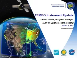
/
TEMPO Science Team Meeting May 31, 2017: TEMPO Science Team Meeting May 31, 2017:

TEMPO Science Team Meeting May 31, 2017: - PowerPoint Presentation

pasty-toler
pasty-toler . @pasty-toler
Follow
390 views
Uploaded On 2017-11-09

TEMPO Science Team Meeting May 31, 2017: - PPT Presentation

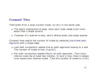
How Early A dopters have Succeeded Bruce Doddridge On behalf of Doreen Neil H ow other Early Adopters have succeeded Created Applications Working Groups that engaged specific users particularly ID: 603944

applications data air tempo data applications tempo air quality early applied satellite science nasa users team earth adopters observations

Share:

Link:

Embed:

Download Presentation from below link

Download Presentation The PPT/PDF document "TEMPO Science Team Meeting May 31, 2017:" is the property of its rightful owner. Permission is granted to download and print the materials on this web site for personal, non-commercial use only, and to display it on your personal computer provided you do not modify the materials and that you retain all copyright notices contained in the materials. By downloading content from our website, you accept the terms of this agreement.


Presentation Transcript

Slide1

TEMPO Science Team Meeting May 31, 2017:

How Early Adopters have SucceededBruce DoddridgeOn behalf of Doreen NeilSlide2

H

ow other Early Adopters have succeededCreated Applications Working Groups that engaged specific users, particularly operational agencies with mandates and resourcesUser guidance factored into early definition of (applied) data products and product featuresScience Team algorithm developers worked closely with Early AdoptersApplications leads identified training needs for applied users and held training sessions

Science team organized “synthetic” data distribution and access

Science Team members who were responsible for algorithms and/or data products worked directly with specific users to develop applied products.

“Early Adopters” are a subset of users who apply their own resources to demonstrate the value of NASA data for their own particular system, model, or application.

DS

missions received

funding

to establish applications and support

mission-specific applications coordinators (not applicable to Earth Venture missions).Slide3

About NASA Applied Sciences Program (ASP):

Discovering innovative and practical uses of Earth observationsASP works with partners to build capacity

ASP funds projects for innovative and practical ways to use space-based environmental information that improves decisions and benefits society.

Users help identify new opportunities (projects)

ASP –sponsored workshops address topics in depth and help people make connections between science and users.

from

(https://appliedsciences.nasa.gov

/)Slide4

NASA’s Applied Sciences Program:

Health & Air Quality focus areaPromotes uses of Earth observations data and models regarding implementation of air quality standards, policy, and regulations for economic and human welfare. Recently noted activities include:The U.S. Environmental Protection Agency integrated Aura, Aqua, and Terra data into the AirNow air-quality decision support system, which health officials use to alert the public about hazardous pollution.AirNow

- Improving Air Quality Maps with Satellite

Data

Incorporating Space-borne Measurements to Improve Air Quality Decision Support

SystemsSlide5

Case Studies have impact

Case Studies reported in video communicate more clearly than charts.  The satellite data has real value in producing an Air Quality Index that actually protects the public from harm by allowing them to make decisions that protect their health and wellbeing. If the satellite data were not there, there would be no indication of this poorer air quality. In the Missouri fires case (see video) the addition of satellite data leads to identification of poorer air quality by including satellite observations of smoke in an otherwise unmonitored area of Northern MissouriSlide6

Engage Specific User Groups

“This [the satellite data] gives you more data than our monitoring network. You can’t ever have enough data.”James Kelly, Georgia Environmental Protection Division“This is the best tool I have seen so far that integrates satellite data with information from ground monitors."

Cassie

McMohan

, Minnesota

Pollution Control

Agency

“Satellite

data help fill in gaps for the existing surface monitoring networks

.”

Scott

Beaver, Bay

Area Air Quality Management

District

Communicating direct feedback from users is essential for success. Slide7

NASA Applications Programs:

Earth VentureApplications activities were not required in the cost-capped EV proposals for spaceflight instruments and missions.Applications are not funded in the formal agreements between NASA and the PIs.Only the first Earth Venture space mission, CYGNSS (EVM-1), has launched (12/2016)Using 8 microsatellites, CYGNSS probes the inner core of hurricanes to learn about their rapid intensification

CYGNSS identified applications in tropical convection, physical oceanography, and hurricane forecast

in their Application Workshop 18 months before launch.

TEMPO is the first Earth Venture Instrument

TEMPO Applications Workshop (June 2016) featured air-quality

f

orecasting evaluation; planning

and

assessment; exceptional events

;

emissions; health

and

exposure;

ozone

c

rop damage

;

dust

,

smoke

,

and volcanic ash; and lightning NOx

TEMPO Science Team partners with NASA’s airborne science program and the GEO-CAPE study team.Slide8

TEMPO Early Adopters up to now

Early Adopters tend to develop into an expert user community.For TEMPO, working closely with algorithms has focused on the “synthetic” data produced during field campaigns using airborne instruments, surface networks, LEO satellite data and a TEMPO simulator (GEO-TASO).Before launch: understand the temporal evolution of near surface layer in different ecosystems using an integrated observing strategy (episodic)After launch: Continuous TEMPO observations from space add to the observationsTEMPO also leverages NASA’s first Air Quality Applied Science Team, and its follow-on, H-AQAST.

The modeling frameworks used in local and regional AQ work are essential toolsSlide9

Suggestions for evolving

TEMPO applicationsEstablish an active TEMPO Applications Working Group to help coordinate applications activities, interact with NASA’s Applied Science Program, advocate for future solicitations, and provide use cases.Identify “communities of practice” (like Early Adopters and strategic partners) and “communities of potential”, and establish cooperative agreements to formalize.GEO-CAPE is a strategic partner for TEMPO.

The CEOS

Atmospheric Composition Virtual Constellation

is a strategic partner; meeting at CNES June 29, 2017

Engage in pre-launch studies and activities and assess tangible outcomes with users

Streamline access to data and use of data at launch

Identify, develop, and communicate quantitative metrics for applicationsSlide10

Early Adopter Success Summary

Communicate, communicate, communicate.Let NASA and communities of practice know what we plan to do, what we are doing, and what we have learned.Slide11
Slide12

NASA Applied Sciences

Program (ASP) Key MetricApplication Readiness Levels are the Applied Sciences Program analogy to Technical Readiness Levels for NASA hardwareEach project is expected to advance one “Application Readiness Level” each year of funding.Full communication from fundedprojects to ASP, communities of practice, and the public is expected

ASP fosters skill in the project teams to

measure the socioeconomic impacts

of Earth observations