/
GEOGRAPHY HANDBOOK GEOGRAPHY HANDBOOK Objectives :  The student will . . . GEOGRAPHY HANDBOOK GEOGRAPHY HANDBOOK Objectives :  The student will . . .

GEOGRAPHY HANDBOOK GEOGRAPHY HANDBOOK Objectives : The student will . . . - PowerPoint Presentation

phoebe-click
phoebe-click . @phoebe-click
Follow
344 views
Uploaded On 2019-11-06

GEOGRAPHY HANDBOOK GEOGRAPHY HANDBOOK Objectives : The student will . . . - PPT Presentation

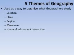
GEOGRAPHY HANDBOOK GEOGRAPHY HANDBOOK Objectives The student will 1 E xamine the five themes of geography 2 Explore how they aid geographic observation and analysis 3 Identify some ways in which the geography of the United ID: 763828

handbook geography land map geography handbook map land human people environment physical states united area location lines place ideas

Share:

Link:

Embed:

Download Presentation from below link

Download Presentation The PPT/PDF document "GEOGRAPHY HANDBOOK GEOGRAPHY HANDBOOK Ob..." is the property of its rightful owner. Permission is granted to download and print the materials on this web site for personal, non-commercial use only, and to display it on your personal computer provided you do not modify the materials and that you retain all copyright notices contained in the materials. By downloading content from our website, you accept the terms of this agreement.


Presentation Transcript

GEOGRAPHYHANDBOOK

GEOGRAPHY HANDBOOK Objectives : The student will . . . 1. E xamine the five themes of geography. 2. Explore how they aid geographic observation and analysis 3. Identify some ways in which the geography of the United States has affected its development.

GEOGRAPHY HANDBOOK The Landscape of America Geography is more than the study of the land and people. It also involves the relationship between people and their environment. The United States is part of the North American continent. It is filled with an incredible variety of physical features, natural resources, climatic conditions and people which have in turn affected the development of the United States.

GEOGRAPHY HANDBOOK 5 Themes of Geography 1. Location “Where am I?” Your answer to this question is your location. One way to answer it is to use absolute location . That means you’ll use the coordinates of longitude and latitude to give your answer. Most people will probably use relative location to answer the question. Relative location describes where a certain area is in relation to another area. What is the relative location of your school?

2. PlacePlace refers to the physical and human factors that make one area different from another. Physical characteristics are natural features, such as physical setting, plants, animals, and weather. Human characteristics include cultural diversity and the things people have made – including language, the arts, and architecture. What physical and human characteristics make where you live unique? GEOGRAPHY HANDBOOK

3. RegionThe world is broken down into regions. A region can be as large as a continent or as small as a neighborhood. A region has shared characteristics that set it apart. These characteristics might include political division, climate, language, or religion. What characteristics does your town share with nearby cities or towns? GEOGRAPHY HANDBOOK

4. MovementMovement refers to the shifting of people, goods, and ideas from one place to another. Movement causes ideas to travel from place to place. Technology has quickened the movement of ideas and goods. What are some of the different ways you spread information and ideas? GEOGRAPHY HANDBOOK

5. Human – Environment InteractionHuman – environment interaction refers to ways people interact with their environment. What are ways that people in your city or town have changed their environment? GEOGRAPHY HANDBOOK

GEOGRAPHY HANDBOOK 5 Themes of Geography Review ___1. Location A. Refers to the shifting of people, goods, and ideas from one place to another. ___2. Place B. Refers to ways people interact with their environment. ___3. Region C. “Where am I?” ___4. Movement D. Refers to the physical and human factors that make one area different from another. ___5. Human-Environment interaction E. Shared characteristics that set it apart.

GEOGRAPHY HANDBOOK 5 Themes of Geography Review _C_1. Location A. Refers to the shifting of people, goods, and ideas from one place to another. _D_2. Place B. Refers to ways people interact with their environment. _E_3. Region C. “Where am I?” _A_4. Movement D. Refers to the physical and human factors that make one area different from another. _B_5. Human-Environment interaction E. Shared characteristics that set it apart.

Map BasicsGeographers use many different types of maps, and these maps all have a variety of features.Types of Maps 1) Physical Maps – show mountains, hills, plains, rivers, lakes, oceans and other physical features of an area. 2) Political Maps – show political units, such as countries, states, provinces, counties , districts, and towns. Each unit is normally shaded a different color , represented by a symbol, or shown with a different typeface. 3) Historical Maps – illustrate such things as economic activity, migrations, battles , and changing national boundaries. GEOGRAPHY HANDBOOK

What type of map is below? GEOGRAPHY HANDBOOK

What type of map is below? - - Political Map GEOGRAPHY HANDBOOK

What type of map is below? GEOGRAPHY HANDBOOK

What type of map is below? - - Physical Map GEOGRAPHY HANDBOOK

What type of map is below? GEOGRAPHY HANDBOOK

What type of map is below? - - Historical Map GEOGRAPHY HANDBOOK

Reading a MapLines – indicate political boundaries, roads and highways, human movement, and rivers and other waterways. Symbols – represent such items as capital cities, battle sites, or economic activities. Labels – words or phrases that explain various items or activities on a map. Compass Rose – shows which way the directions north, south, east and west point on the map. Scale – shows the ratio between a unit of length on a map and a unit of distance on the earth. A typical one-inch scale indicates the number of miles and kilometers that length represents on the map. Colors – show a variety of information on a map, such as population density or the physical growth of a country. Legend or Key – lists and explains the symbols, lines, and colors on a map. Lines of Longitude – imaginary north-south lines that run around the globe. Lines of Latitude – imaginary east-west lines that run around the globe. Together, latitude and longitude lines form a grid on a map or globe to indicate an area’s absolute location . GEOGRAPHY HANDBOOK

GEOGRAPHY HANDBOOK Longitude Lines -Imaginary lines that run north to south around the globe and are known as meridians . -Show the distance in degrees east or west of the prime meridian . -The prime meridian is a longitude line that runs from the North Pole to the South Pole. It passes through Greenwich, England, and measures 0* longitude.

Latitude LinesImaginary lines that run east to west around the globe and are known as parallels . Show distance in degrees north or south of the equator . The equator is a latitude line that circles the earth halfway between the North and South poles. it measures 0* latitude. The tropics of Cancer and Capricorn are parallels that form the boundaries of the Tropics, a region that stays warm all year. Latitude and longitude lines appear together on a map and allow you to pinpoint absolute location. You express absolute location through coordinates of intersecting lines. These are measured in degrees. GEOGRAPHY HANDBOOK

Absolute Location ReviewFind the following locations using lines of latitude and longitude. 1. 30’ N, 90’ W (North America) 2. 34’ S, 58’ W (South America) 3. 60’ N, 30’ E (Europe) 4. 31’ N, 30’ E (Africa) GEOGRAPHY HANDBOOK

Absolute Location ReviewFind the following locations using lines of latitude and longitude. 1. 30’ N, 90’ W (North America) - - New Orleans Louisiana 2. 34’ S, 58’ W (South America) - - Bueno Aries, Argentina 3. 60’ N, 30’ E (Europe) - - St. Petersburg, Russia 4. 31’ N, 30’ E (Africa) - - Alexandria, Egypt GEOGRAPHY HANDBOOK

HemisphereA term for half the globe. The globe can be divided into Northern and Southern hemispheres ( separated by the equator) or into Eastern and Western hemispheres . GEOGRAPHY HANDBOOK

ProjectionsA way of showing the curved surface of the earth on a flat map. Flat maps cannot show the size, shape, and direction of a globe all at once with total accuracy. There are four types of projections. 1. Mercator Projection – shows most of the continents as they look on a globe . 2. Azimuthal Projection – shows the earth so that a straight line from the central point to any other point on the map gives the shortest distance between the two points . 3. Homolosine Projection – shows the accurate shapes and sizes of the landmasses 4. Robinson Projection – shows the entire earth with nearly the true sizes and shapes of the continents and oceans. GEOGRAPHY HANDBOOK

Physical Geography of the United States - Physical geography involves all the natural features on the earth. This includes land, resources, climate , and vegetation. Land – The United States covers 3,717,796 square miles. On the US mainland, a central plain separates large mountains in the West and low mountains in the East. Plains make up almost half of the country, while mountains and plateaus make up a quarter each. There are an abundance of lakes in the US. 20% of the US is farmed. Urban areas cover only about 2% of the nation. What is the land like around your city or state? GEOGRAPHY HANDBOOK

Physical Geography of the United States 2. Resources – Coal, oil, natural gas, lead, zinc, uranium, gold , and silver have helped the United States become the world’s leading industrial nation – producing nearly 21% of the world’s goods and services. These resources also helped the United States become the world’s largest producer of energy and the largest consumer of it. Other natural resources include the Great Lakes which contain about 20 % of the world’s total supply of fresh surface water. What are the different natural resources that you and your family use in your daily lives? GEOGRAPHY HANDBOOK

Physical Geography of the United States 3. Climate – The US contains a variety of climates. Most of the US experiences a continental climate or distinct change of season. Human activities have affected the climate (pollution). How would you describe the climate where you live? GEOGRAPHY HANDBOOK

Physical Geography of the United States 4. Vegetation – There are between 20,000 and 25,000 species and subspecies of plants and vegetation that grow in the US. Climate often dictates the type of vegetation found in a region . What kinds of trees or plants grow in your region? GEOGRAPHY HANDBOOK

GEOGRAPHY HANDBOOK Geographic Dictionary -Volcano - an opening in the earth, usually raised, through which gasses and lava escape from the earth’s interior. -Strait - a narrow strip of water connecting two large bodies of water. -Cape - a pointed piece of land extending into an ocean or lake. -Sea Level - level of the oceans surface, used as a reference point when measuring the height or depth of the earth’s surface. -Bay – part of an ocean or lake partially enclosed by land. -Harbor – a sheltered area of water, deep enough for docking ships. -River (mouth) – the place where a river flows into a lake or ocean. -Marsh – soft, wet, low-lying, grassy land that serves as a transition between water and land. -Delta – a triangular area of land formed from deposits at the mouth of a river. - F lood Plain – flat land near the edges of rivers formed by mud and silt deposited by floods. -Island – a body of land surrounded by water. -Swamp – an area of land that is saturated by water. -Butte – a raised, flat area of land with steep cliffs, smaller that a mesa. -Oasis – a spot of fertile land in a desert, fed by water from wells or underground springs. -Desert – a dry area where few plants grow. -Mesa – a wide, flat-topped mountain with steep sides, larger that a butte. -Prairie – a large, level area of grassland with few or no trees. -Steppe – a wide, treeless plain. -Mountain – natural elevation of the earth’s surface with steep sides and greater height than a hill. -Valley – low land between hills or mountains. -Glacier – a large ice mass that moves slowly down a mountain or over land. -Cataract – a large, powerful waterfall. -Canyon – a narrow, deep valley with steep sides. -Cliff – the steep, almost vertical edge of a hill, mountain, or plain. -Plateau – a broad, flat area of land higher that the surrounding land.

GEOGRAPHY HANDBOOK Human Geography of the United States - Human geography focuses on people’s relationships with each other and the surrounding environment. It includes two main themes in geography: Human-environment interaction and movement. 1. Humans Adapt to Their Surroundings – Humans have always adapted to their environments. Americans have adapted to their environment by building dams, bridges, and tunnels. What are some of the ways in which you interact with your environment on a daily basis?

Human Geography of the United States 2. Humans Affect the Environment – When humans interact with their environment , sometimes nature suffers. What are some of the environmental problems in your city or town ? 3. Preserving and Restoring – People have been working to blend economic progress with conservation . What are some of the ways you help the environment? GEOGRAPHY HANDBOOK

Human Geography of the United States 4. Human Movement – In prehistoric times, people roamed the earth in search of food. Today in t he US, people move from place to place for many different reasons (cost of living, job availability and climate). Has your family ever moved? If so, what were some of the reasons? 5. Humans Spread Ideas and Information – People from all over the world have come to the US. They have brought with them food, music , language, technology , and other aspects of their culture. As a result , the US is one of the most culturally rich and diverse nations in the world. Today, the spreading of ideas and customs does not rely solely on human movement. Technology spreads ideas and information throughout the world. How have computers and the Internet affected your life ? GEOGRAPHY HANDBOOK