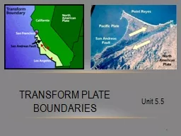
Transform Plates 2 Along a transform plate boundary also called transform fault plates slide horizontally past one another without producing or destroying lithosphere The nature of transform faults was discovered in 1965 by Canadian geologist J ID: 792090
Download The PPT/PDF document "1 Unit 5.5 Transform Plate Boundaries" is the property of its rightful owner. Permission is granted to download and print the materials on this web site for personal, non-commercial use only, and to display it on your personal computer provided you do not modify the materials and that you retain all copyright notices contained in the materials. By downloading content from our website, you accept the terms of this agreement.
Slide1
1
Unit 5.5
Transform Plate Boundaries
Slide2Transform Plates
2
Along a transform plate boundary, also called transform fault
, plates slide horizontally past one another without producing or destroying lithosphere.The nature of transform faults was discovered in 1965 by Canadian geologist J.
Tuzo
Wilson
, who proposed that these large faults connect two spreading centers or two trenches.
Slide3Transform Plates
3
Most transform faults are found on the ocean floor,
where they offset segments of the oceanic ridge system.Typically, transform faults are part of prominent linear breaks in the seafloor known as fracture zones, which include both active transform faults and their inactive extensions into the plate interior.
Slide44
Slide5Transform Plates
5
The
trend of these fracture zones roughly parallels the direction of the plate motion at the time of their formation.Thus,
these structures are useful in mapping the direction of plate motion in the geologic past.
Slide6Transform Plates
6
In another role, transform faults provide the means by which the oceanic crust created at ridge crests can be transported to a deep-ocean trench, where it will be destroyed.
Most transform fault boundaries are located within the ocean basins; however, a few cut through continental crust.
Slide77
Slide8Changing of Plate Boundaries
8
Although the total surface of the Earth does not change, the size and shape of individual plates are constantly changing.
For example, the African and Antarctic plates are continually growing due to being at sites of seafloor production.
Slide9Changing of Plate Boundaries
9
By contrast, the Pacific plate is decreasing in size due to subduction
.Plate
boundaries can be created or destroyed in response to changes in the forces acting on the lithosphere.
Slide10Changing of Plate Boundaries
10
Plates
can be ripped apart due to tensional forces and plates can merge into one, due to compressional forces. The
breakup of Pangaea is a classic example of how plate boundaries change through time.
Slide11Breakup of Pangaea
11
Wegener used evidence from fossils, rock types, and paleoclimate to create a jigsaw-puzzle fit of the continents, thereby creating the supercontinent of Pangaea.
In a similar manner,
geologists have recreated the steps in the breakup of Pangaea, an event that took place about 180 million years ago.
Slide12Breakup of Pangaea
12
From this work,
the dates when individual crustal fragments separated from one another and their relative motions have been well-established.
Slide13Breakup of Pangaea
13
The
first major event during the breakup of Pangaea was the separation of North America and Africa, which marked the opening of the North Atlantic.
This
occurred about 150 million years ago.
Slide14Breakup of Pangaea
14
By
90 million years ago, the South Atlantic had opened.
Continued
breakup in the Southern Hemisphere led to the separation of Africa, India, and Antarctica.
Slide15Breakup of Pangaea
15
About 50 million years ago, Southeast Asia had docked with Eurasia, while India continued its northward journey.
At about 20 million years ago, India had begun its ongoing collision with Eurasia to create the Himalayas and the Tibetan Highlands.
Slide16Breakup of Pangaea
16
During
the past 20 million years of Earth’s history, Arabia has rifted from Africa created the Red Sea, while Baja California, has separated from Mexico to form the Gulf of California
.
https://
vimeo.com/14258924
Slide17Plate Tectonics in the Future
17
Based on present-day movement of the plates, geologists have been able to predict the likely course of movements of the tectonic plates in the geologic future – 50 million years and 250 million years.
Slide18Plate Tectonics in the future
18
Over the next 50 million years, the world might look as follows.
In North America, the Baja Peninsula will slide past the North American plate.
If this northward migration continues, the Baja Peninsula will
collide with the Aleutian Islands.
Slide19Plate Tectonics in the future
19
If Africa continues moving northward, it
will collide with the Eurasian plate, closing the Mediterranean and initiating another major mountain building episode.Australia will be along the equator and along with New Guinea, will collide with Asia.
North and South America will begin to separate.
Slide20Plate Tectonics in the future
20
A few geologists have even speculated on the nature of the globe
250 million years in the future.The
next supercontinent may form as a result of subduction of the floor of the Atlantic Ocean, resulting in the collision of the Americas with the Eurasian-African landmass.
Slide21Plate Tectonics in the future
21
Support for the possible closing of the Atlantic comes from a similar event when an ocean that predates the Atlantic closed during the formation of Pangaea.
During the next 250 million years, Australia is projected to collide with Southeast Asia.
Slide22Plate Tectonics in the future
22
If
this scenario is accurate, the dispersal of Pangaea will end when the continents reorganize into the next supercontinent.
https://
www.youtube.com/watch?v=cW6rMzSOmvU