/
CPC Monthly Climate Review CPC Monthly Climate Review

CPC Monthly Climate Review - PowerPoint Presentation

risilvia
risilvia . @risilvia
Follow
342 views
Uploaded On 2020-06-29

CPC Monthly Climate Review - PPT Presentation

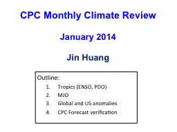
January 2014 Jin Huang Outline Tropics ENSO PDO MJO Global and US anomalies CPC Forecast verification 2 Tropics ENSO PDO ENSO Neutral 3 Dec 2013 is similar to Oct Nov 2013 ID: 789367

pacific anomalies mjo january anomalies pacific january mjo eastern westerly ocean equatorial cold pdo late forecast air western convection

Share:

Link:

Embed:

Download Presentation from below link

Download The PPT/PDF document "CPC Monthly Climate Review" is the property of its rightful owner. Permission is granted to download and print the materials on this web site for personal, non-commercial use only, and to display it on your personal computer provided you do not modify the materials and that you retain all copyright notices contained in the materials. By downloading content from our website, you accept the terms of this agreement.


Presentation Transcript

Slide1

CPC Monthly Climate ReviewJanuary 2014Jin Huang

Outline:

Tropics (ENSO, PDO)

MJO

Global and US

anomalies

CPC

Forecast

verification

Slide2

2Tropics (ENSO, PDO)

Slide3

ENSO Neutral3

Dec

2013 is

similar to Oct –Nov 2013

Warm

SSTAs over the North Pacific

;Warm SSTAs over the Atlantic coast (which has been persistent for more than 10-months)

Slide4

During May-September 2013, well below-average SSTs were observed over the eastern half of the Pacific.

In the last couple of weeks, SSTs have been below average between 170ºW-110ºW.

Equatorial

Pacific SST Departures (

o

C

)

Longitude

Time

Slide5

Niño Region SST Departures (oC) Recent Evolution

The latest weekly SST departures are:

Niño 4 -0.2ºC

Niño 3.4 -0.7ºC

Niño 3 -0.7ºC

Niño 1+2 0.2ºC

Slide6

During the last 2 months, below-average temperatures developed in the eastern Pacific, associated with the upwelling phase of a Kelvin wave.

Recently, negative subsurface anomalies have persisted in the eastern Pacific, while positive anomalies have shifted slightly eastward in the central Pacific.

Sub-Surface Temperature Departures (

o

C

)

in the Equatorial Pacific

Most recent pentad analysis

Longitude

Time

Slide7

Tropical OLR and Wind AnomaliesIn January 2014Upper-level (200-hPa) westerly wind anomalies were evident over the eastern equatorial Pacific Ocean.

Negative OLR anomalies (enhanced convection and precipitation, blue shading) were observed over eastern Indonesia, the Philippines, and the equatorial western Pacific. Positive OLR anomalies (suppressed convection and precipitation, red shading) were evident over the central equatorial Pacific.

Anomalous low-level (850-hPa) westerly winds were evident in the far western equatorial Pacific.

Slide8

PDO and NINO3.4

There

was a regime shift of PDO around 1999.

Negative PDO phase since May 2010

During

the positive phase of the PDO, PDO either lagged NINO3.4 (1983-84, 1993-1994) or was in phase with NINO3.4 (1986-87, 1997-98).

The

correlation between monthly PDO and NINO3.4 at zero lag is 0.3 in 1982-1998 and 0.56 in 1999-2013. The higher correlation since 1999 is partly attributed to the fact that both PDO and NINO3.4 were in prevalent negative phase since 1999

.

Slide9

Most of the models predicted ENSO-neutral to continue into the Northern Hemisphere spring, but some models suggest El Nino will emerge during summer.

The consensus forecast favors ENSO-neutral conditions in spring, and the probability for ENSO-neutral and El Nino is equal in summer.

IRI/CPC NINO3.4 Forecast Plume

Slide10

10MJO

Slide11

850-hPa Vector Wind Anomalies (m s

-1

)

Note that shading denotes the zonal wind anomaly

Blue shades

: Easterly anomalies

Red shades

: Westerly anomalies

Easterly anomalies expanded into the eastern Maritime Continent, while westerly anomalies persisted across the western Maritime Continent and northern Australia.

Westerly anomalies developed across southern Africa and parts the southwest Indian Ocean during the past five days.

Westerly anomalies were observed across much of the equatorial Pacific east of the Date Line.

Slide12

850-hPa Zonal Wind Anomalies (m s-1)

Westerly anomalies (orange/red shading) represent anomalous west-to-east flow

Easterly anomalies (blue shading) represent anomalous east-to-west flow

In late August and early September, westerly (easterly) anomalies increased over the eastern (western) Pacific in associated with renewed MJO activity.

During October, equatorial

Rossby

wave activity was strong from 160E to 100E as westward movement features are evident (red box). MJO activity was less coherent during this period.

During November and December, easterly anomalies were persistent from 120E to near the Date Line. Westerly anomalies were also evident across the Indian Ocean during this period.

During January, westerly anomalies intensified and shifted east to the Maritime Continent and West Pacific, but easterly anomalies over the Maritime Continent disrupted the signal during early February.

Time

Longitude

Slide13

Outgoing Longwave Radiation (OLR) Anomalies (7.5°N-7.5°S)

Drier-than-normal conditions, positive OLR anomalies (yellow/red shading)

Wetter-than-normal conditions, negative OLR anomalies (blue shading

)

Time

Longitude

The MJO was active from late August through early October with the enhanced phase propagating eastward from the Indian Ocean to the western Pacific Ocean over this period.

The MJO was generally weak or incoherent for much of November and other types of coherent tropical

subseasonal

variability were very active.

A large area of enhanced convection developed over the Indian Ocean during late November and propagated slowly eastward to the west Pacific Ocean by late January.

This feature weakened during early February as suppressed convection propagated from the Indian Ocean to the Maritime Continent.

Slide14

200-hPa Velocity Potential Anomalies (5°S-5°N)

Time

Longitude

The MJO was not active during late July and much of August, but strengthened during late August and September, with eastward propagation of robust upper-level velocity potential anomalies (alternating dashed and dotted lines). Other modes of tropical

intraseasonal

variability are also evident.

From late October to early December, the MJO was not very strong or coherent. There was evidence of coherent eastward propagation at times during this period, but much of this activity exhibited fast propagation speeds more consistent with atmospheric Kelvin waves.

A slower eastward propagation of 200-hPa velocity potential anomalies was observed from mid-December to mid-January across the Indo-Pacific warm pool region (red box), while positive anomalies propagated from the Indian Ocean to the Maritime Continent during late January and early February.

Slide15

MJO Summary (as of Feb. 10)

The MJO remained incoherent during the past week

, with influence from more localized

subseasonal

features, such as

tropical cyclone activity over the southwestern Indian Ocea enhanced

northern Australian monsoon activity, suppressed convection over South America

There is considerable spread among the model guidance resolving the future evolution of the

MJO

Based on the latest observations and most model forecasts, the MJO is forecast to remain weak during the next 1-2 weeks, while lower frequency signals continuing to dominate the pattern.

Slide16

16Global and US anomalies in January 2014N. American Cold events and one diagnosis (prediction) theorydrought

Slide17

Global SST Anomaly (0C) and Anomaly Tendency

SST

was above-normal (below-normal) in the western (central-eastern) tropical Pacific.

A

north-south dipole of SSTA presented in the N. Atlantic.

A cooling (warming) tendency presented in the western (eastern) N. Pacific.

A cooling tendency was observed in the central-eastern equatorial Pacific.

A north-south dipole of SSTA tendency presented in the N. Atlantic.

Slide18

T2m Anomaly January 2014

Slide19

January 2014 Precipitation (Rain gauge)19

Slide20

January 2014 Temperature and Precip Ranks20

Slide21

January 2014 500mb Height21

Slide22

AO and NAO

Slide23

Variability of Mass Transport into Polar Stratosphere and Winter Cold Air Outbreaks in Mid-latitudesMing CaiDepartment of Earth, Ocean, and Atmospheric Science, Florida State University

Acknowledgement: Huug M. van den Dool, Y-Y Yu, R-C Ren

23

Slide24

Mean meridional mass circulation in winter hemisphere (Cai and Shin 2014)24

Slide25

60N

25N

90N

Stronger Meridional Mass

Circulation near surface

Mass circulation variability and cold air outbreaks in the mid-latitudes

Warm

air

Cold

air

60N

25N

90N

Weaker Meridional Mass

Circulation near surface

Warm

air

Cold

air

Less cold air outbreaks in mid-latitudes

Coldness in high latitudes

More cold air outbreaks in mid-latitudes

Warmness in high latitudes

25

Slide26

Survey of mass circulation crossing 60N in winter of 2013-14

Stratosphere

Warm Branch

Cold Branch

climatology

1SD

-1SD

12/9/13

1/1/14

1/18/14

26

Slide27

Slide28

Slide29

29Global and US anomalies in January 2014N. American Cold eventsdrought

Slide30

30

P

a

nomalies over the United States

January

A very dry month

Over the west coast, it has been dry since Oct 2013 and in January ,rainfall anomalies were 4mm/day below normal

Rainfall also was below normal over the Southeast and the Gulf states

Seasonal

A very dry season

Slide31

31SPI

SPI3:

SPI3 shows D3-D4 Drought over the Pacific Northwest and California

Drought over the Great Plains

SPI6:

D3-D4 drought over California, D3 drought over the Central U.S.

dryness over California appeared in SPI6-24

Slide32

32

Enhanced

Convection

over the western Pacific centered at 120- 180

Suppressed

convection over the Central Pacific

This pattern shifted about 20degrees in comparison to Dec 2013.

This convection pattern still implies dryness over California

A PNA type of pattern with positive anomalies over the West Coast, the wave train also shifted inland in comparison to the last month

Slide33

33

California rainfall

28Jan-8Feb

USGS Feb 9

Soil moisture

and

Runoff

monthly means

still

show dryness ( both NLDAS)

Slide34

Drought Outlooks34

Seasonal

Monthly

Monthly

Slide35

35Forecast Verification

Slide36

All models from NMME forecast the ENSO-neutral 2012/13 winter well.

http://www.cpc.ncep.noaa.gov/products/NMME/

The North America Multi-Model Ensemble (NMME)

Slide37

RT verification: CONUSYear 1Year 2

T2m

Prate

NMME Forecast Verification

for Last 2

years

Slide38

NMME Jan. 2014 T2m Forecast Verification

Slide39

NMME Jan. 2014 Precip Forecast Verification