/
Eruption of Chaiten during a storm at night Eruption of Chaiten during a storm at night

Eruption of Chaiten during a storm at night - PowerPoint Presentation

robaut
robaut . @robaut
Follow
343 views
Uploaded On 2020-06-30

Eruption of Chaiten during a storm at night - PPT Presentation

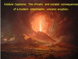
Source Eyevine Volcanic Monitoring amp Hazards Lava Flows Explosive blasts Pyroclastic flows Volcanic ash Lahars Volcanic gases USGS USGS 1 Monitoring Volcanoes The USGS Volcano Hazards Program monitors volcanoes for signs of possible activity ID: 790377

eruption volcanic hazards ash volcanic eruption ash hazards usgs volcano flows hazard 1980 gases lava helens deformation mount ground

Share:

Link:

Embed:

Download Presentation from below link

Download The PPT/PDF document "Eruption of Chaiten during a storm at ni..." is the property of its rightful owner. Permission is granted to download and print the materials on this web site for personal, non-commercial use only, and to display it on your personal computer provided you do not modify the materials and that you retain all copyright notices contained in the materials. By downloading content from our website, you accept the terms of this agreement.


Presentation Transcript

Slide1

Eruption of Chaiten during a storm at night

Source: Eyevine

Volcanic Monitoring &

HazardsLava FlowsExplosive blastsPyroclastic flowsVolcanic ashLaharsVolcanic gases

Slide2

USGS

USGS

1. Monitoring

Volcanoes

The USGS Volcano Hazards Program monitors volcanoes for signs of possible activity. Indicators of possible volcanic activity include seismic activity, ground deformation, volcanic gases, and changes in water levels and chemistry.

Seismometers can send information continuously to monitor volcanoes. Geologists look for specific types of earthquakes that are often associated with volcanic activity such as “harmonic tremors” that may indicate the movement of magma.

Slide3

As magma intrudes upward into a volcano, deformation of the ground may be observed.

Ground deformation is monitored with

tiltmeters

and high resolution GPS stations.Inflation may proceed a volcanic eruption followed by deflation USGSUSGS

Slide4

Interferometric

synthetic aperture radar (InSAR) is a form of remote sensing (from a space-borne platform) using radar to detect changes in the shape of the Earth’s surface. The

interferogram shows ground deformation in the Kilauea caldera from January 17-February 19, 2010.

Each color cycle is represents ~1.5 cm deformation; it shows >3 cm change related to cycles of deflation and inflation centered within Kilauea caldera. Interferograms such as this can be used to monitor the inflation of a volcano that may proceed an eruption.

Slide5

Prior to the massive 1980 eruption of Mt. Saint Helens, a "bulge" developed on the north side as magma pushed up within the peak. Measurements indicated the bulge was growing at a rate of up to ~1.5 meters per day. Part of the volcano's north side had been pushed upwards and outwards over 135 meters.

Slide6

Lava flows are probably the least hazardous of all processes in volcanic eruptions.

The style of eruption (explosive or more fluid) depends on a number of factors including lava composition and volatile content.

Basaltic (mafic) lava flows are generally very fluid (low viscosity) and can travel significant distances.

2. Volcanic Hazards: Lava Flows

Hawaii News Now

Slide7

The map shows the lava flow hazard on the island of Hawaii.

The zones of the hazard are defined by the proximity to an active vent and topography (lava flows downhill).

Kilauea has been erupting nearly continuously since 1983.

Slide8

3.

Volcanic

Hazards: Explosive Blasts

Explosive blasts from violent volcanic eruptions can be a significant hazard. The hazard may be signficantly increased with a lateral blast such as the 1980 eruption of Mount St. Helens. The images show the change in Mount St. Helens as a result of the lateral blast during the 1980 eruption. Note that much of the flank of the mountain was blown away. prior to the 1980 eruption

after the 1980 eruption

Slide9

http://earthobservatory.nasa.gov/Features/WorldOfChange/sthelens.php

After the 1980 eruption, the blast zone extended up to 19 miles from the volcano and resulting in trees and structures being blown down.

Slowly the forest around Mount St. Helens has slowly recovered.

Slide10

The eruption of a composite volcano can result in the production of a very hot cloud of gas and ash (up to 700°C) that is heavier than air. As it moves out of the volcanic vent, it moves downslope at speeds of up to 80 km/hour.

This is known as an

ash flow or pyroclastic flow

. These types of eruptions can move rapidly up to 10’s of km from their source and are utterly devastating.4. Volcanic Hazards: Pyroclastic Flows

USGS

USGS

Mt. St. Helens

Mayon

Volcano, Philippines

Slide11

Map of hazard zones for pyroclastic flows from future eruptions at or near the summit of Mount Shasta.

Crandell and Nichols, 1987

The photos to the right show debris (pumice, ash, etc.) carried by pyroclastic flows

Slide12

5.

Volcanic

Hazards: Volcanic Ash

Ash can be a significant hazard for infrastructure and health. The 1980 eruption of Mount St. Helens resulted in 540,000,000 tons of ash falling over an area of more than 22,000 square miles.Hazards include:Disruption of infrastructure including electrical grids and water supply.

Navigation hazard for aircraft.

Environmental and agricultural impacts.Human and animal health.

NASA

USGS

Slide13

Volcanic ash from the eruption of Eyjafjallajökull disrupted air travel in Europe in 2010.

The ash is hard and abrasive and can quickly cause significant to jet engines.

There is an international monitoring network to provide data on ash clouds and establish no fly zones.

Volcanic Ash Advisory Center

Slide14

A large eruption can produce a mudflow known as a

lahar

. These occur when the volcanic ash and debris become water-saturated. Composite volcanoes may contain large amounts of water in the form of snow and glaciers that melted nearly instantaneously during a major eruption.

The resulting debris flow moves down valleys and can be very destructive.6. Volcanic

Hazards: Lahars (volcanic mud flows)

5.

Science Kids

Slide15

In 1985, 20,000 people were killed in Colombia by a

lahar when Nevado del Ruiz erupted.

USGS

Slide16

The USGS has installed a network of sensors that detect

lahars

by

measuring ground vibrations. Detection of a lahar would trigger an immediate planned emergency response actions. Dams and other structures have been built to contain or lessen the impact of lahars.

OSU Volcano World

Slide17

7.

Volcanic

Hazards: Volcanic Gases

Gases released by volcanoes include H2O, CO2, sulfur gases, and many other components.

It is estimated that ~3% of deaths related to volcanic hazards are due to gases including asphyxiation and acid corrosion.

The 1986 emission (lake overturn) of volcanic gasses at Lake Nyos in Cameroon resulted in the deaths of ~1700 people and 2500 livestock within 25 km of the lake.

USGS