/
Pelagic Bird Monitoring: Pelagic Bird Monitoring:

Pelagic Bird Monitoring: - PowerPoint Presentation

robaut
robaut . @robaut
Follow
342 views
Uploaded On 2020-08-27

Pelagic Bird Monitoring: - PPT Presentation

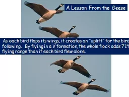
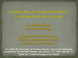
Tips amp Guidelines Dipu Karuthedathu Methodology Current Knowledge on Pelagic birds is minimal Recent trips from various parts of the state have brought out interesting patterns Proposal year round survey from nine coastal districts in Kerala ID: 805712

bird trip pelagic birds trip bird birds pelagic images data gps ensure location transfer set complete drive files safety

Share:

Link:

Embed:

Download Presentation from below link

Download The PPT/PDF document "Pelagic Bird Monitoring:" is the property of its rightful owner. Permission is granted to download and print the materials on this web site for personal, non-commercial use only, and to display it on your personal computer provided you do not modify the materials and that you retain all copyright notices contained in the materials. By downloading content from our website, you accept the terms of this agreement.


Presentation Transcript

Slide1

Pelagic Bird Monitoring:

Tips & Guidelines

Dipu Karuthedathu

Slide2

Methodology

Current Knowledge on Pelagic birds is minimal

Recent trips from various parts of the state have brought out interesting patterns

Proposal

year round survey from nine coastal districts in Kerala

bi-monthly surveys from each district

conducted by minimum of 5 bird watchers/photographers

Simple methodology and data collection methods

Details in the attached document

Slide3

Tips for Regional Coordinators

Contact Forest Department for logistic support (boat, food, safety equipment etc.)

Ensure availability of 5+ birders/birdwatchers for the survey

Make sure that at least few members have reasonably good (DSLR) cameras

This is required as Pelagic bird identification in the field is very difficult and would need help from high quality images

Educate the photographers that they have to contribute the complete set of images from the trip to the trip data base irrespective of the quality

During the trip

Ensure that at least one member has started GPS data collection (See attachment in previous slide for details on how to collect this data)

Ensure that at least few wide angle and zoomed images are taken of the open sea which can be used to evaluate the wind speed

After the trip

Ensure that the complete set of images taken during the trip are transferred to a convenient location accessible to the coordinator (say a pen drive/hard drive)

Transfer the GPS logger output files (KML, GPX, TXT) into the a convenient location accessible to the coordinator

Transfer the Pelagic Trip data sheet, GPS files and the images to a common location for all the surveys (say Google Drive, location to be shared later)

Slide4

Tips for Birders/Photographers

Ensure your own safety and the equipment’s safety. Be prepared for rains

There are only few birds out there. So try to prepare prior to the trip and be familiar with the key features that you should note for a particular group (A crash course is attached in this slide ☺)

Make sure that some one is always monitoring the birds at the front of the boat. Birds could just cross over and disappear and hence could be easily missed!

Whenever a bird is sighted,

Try to note as many features and behavioral traits as possible. Never leave any bird assuming that it is similar to a previously sighted bird! Many Pelagic birds look quite similar and variation are some times very subtle!

Whenever a bird is sighted, try to take an image.

Never leave a bird un-photographed assuming that it has been photographed earlier! Pelagic birds are very confusing and you may hit a jackpot any time!

Similarly, even un-clear photos may be helpful in final identification, hence do not delete/ignore the “not-so-clear” images ☺If you have an android phone, install the application “GPS Logger” and start it at the beginning of the trip, stop it at the end of the trip.At the end of the trip, do not forget to transfer the GPS Logger files and the complete set of photographs to the regional coordinators.