Explore
Featured
Recent
Articles
Topics
Login
Upload
Featured
Recent
Articles
Topics
Login
Upload
Search Results for 'arcgis data'
arcgis data published presentations and documents on DocSlides.
Digimap data in ArcGIS
by natalia-silvester
Guy . McGarva. EDINA Geo User Support. Ian Holmes...
ArcGIS PRO MIGRATION , SUCCESSES, AND LESSONS LEARNED Introduction
by marina-yarberry
ArcGIS PRO MIGRATION , SUCCESSES, AND LESSONS LE...
Publishing and Accessing Services using ArcGIS for Flood An
by test
Harish Sangireddy. The University of Texas at Aus...
How to enter the world of Python Programming for ArcGIS
by celsa-spraggs
Or, a funny thing happened on the way . from an E...
What’s new at ArcGIS 10.2.1 for INSPIRE
by briana-ranney
Roberto Lucchi. Guenther . Pichler. Outline. INSP...
Extending ArcGIS using programming
by tawny-fly
David . Tarboton. GIS in Water Resources. 22 Octo...
GIS Data Collection Using
by ellena-manuel
Esri’s. . Collector App. Harkeerat Kang. 12.7....
Introduction to ArcGIS Planetary Data Analysis
by min-jolicoeur
Peter Fawdon. Department of Earth and Planetary S...
Mapping ACS Data
by olivia-moreira
Jeff Strickland. Assistant Professor of History. ...
2014 ESIP Summer Meeting
by alida-meadow
July 8–11, 2014 . |. Frisco, Colorado. Advanci...
Growing
by myesha-ticknor
OPeNDAP. Support: Current ArcGIS. Workflows and ...
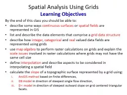
Spatial Analysis Using Grids
by trish-goza
By the end of this class you should be able to: ....
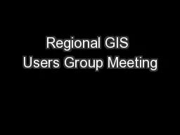
Regional GIS Users Group Meeting
by olivia-moreira
Wednesday, February 18. th. 2009. 10:00 AM - Noo...
Florida Department of Environmental Protection
by faustina-dinatale
Mobile GIS Solutions using ArcGIS Online. Sara Wa...
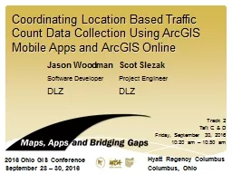
Coordinating Location Based Traffic
by kittie-lecroy
Count Data Collection Using . ArcGIS . Mobile App...
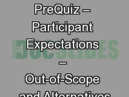
Main Topics PreQuiz – Participant Expectations – Out-of-Scope and Alternatives
by alexa-scheidler
Introduction, Class Goals and reviewing data (. E...
1263703
by cheryl-pisano
...
Cultivating GIS at the Brooklyn Botanic Garden
by yoshiko-marsland
Kyle Heulitt. Advisor: . Professor . Ken . Tammin...
GIS in Water Resources Midterm Review 2018
by cheryl-pisano
Blooms Taxonomy of Educational Objectives. 2. Com...
EPID 799C Fall 2018 Maps 1
by min-jolicoeur
https://geocompr.robinlovelace.net/adv-map.html. ...
User-Defined Layer Selection and Weighting for Initial Emergency Response Risk Mapping
by enjoinsamsung
Jonas Miller . Advisor: Fritz Kessler. Scenario. L...
Nick Tonias, P.E. A Simplified Approach to Implementing GIS
by shangmaxi
1985. . The CEDRA Corporation is established. . ....
Esri’s ArcGIS Enterprise
by luna
IT4GIS. Keith T. Weber, GISP. GIS Director. ISU-GI...
Embracing JavaScript API for Webpages
by bella
10. /2014. Austin Hildreth. 1.2 Million Customers....
ArcGIS Collector and Accuracy of Location and Data
by natalia-silvester
2017 Indiana GIS Day and Conference. Joe . Madej....
[BEST]-ArcGIS Pro 2.x Cookbook Create, manage, and share geographic maps, data, and analytical models using ArcGIS Pro
by kaseemjayleen
The Desired Brand Effect Stand Out in a Saturated ...
Environmental Sensitivity to Oil Spills in Gulf Shores, AL
by danika-pritchard
Prepared by: Matthew . Dobbertien. 12/01/2011. GI...
Using ArcGIS ModelBuilder for Conservation & Ag Drainag
by calandra-battersby
Janell Weiss. Nutrient Mgmt. Specialist/Ag Techni...
How does a community utilize ESRI’s
by min-jolicoeur
ArcGIS Online functionality and incorporate. into...
Automating Service Publishing in an
by liane-varnes
Optimized Server Environment. Brandon Longenberge...
Illegal Border Crossers and
by luanne-stotts
Wildfires in AZ. Geoffrey Krassy. GEOG 594A. Pr...
Community-wide urban stormwater planning utilizing LiDAR, the WinSLAMM model and GIS
by cheryl-pisano
Dan Murphy. Rebecca Gronewold. UNI GeoTREE Center...
The Geo-Web: Enabling GIS on the Internet
by pamella-moone
IT4GIS. Keith T. Weber, GISP. GIS Director. ISU-G...
Python for ArcGIS Pro: Automate cartography and data analysis using ArcPy, ArcGIS API for Python, Notebooks, and pandas
by leonitusbowden
It’s no secret that this world we live in can be...
ArcGIS Pro 2.x Cookbook: Create, manage, and share geographic maps, data, and analytical models using ArcGIS Pro
by thadeusdenym
It’s no secret that this world we live in can be...
[READING BOOK]-ArcGIS Pro 2.x Cookbook: Create, manage, and share geographic maps, data, and analytical models using ArcGIS Pro
by aariiaankrrish
The Desired Brand Effect Stand Out in a Saturated ...
Python Tips/Tricks Scripting Rest Service Downloads
by queenie
Tom Laue. Citizens Energy Group. Overview. ArcMap:...
arcpy Dr Andy Evans This lecture
by finley
Introduction to . arcpy. Debugging. Using . arcpy....
Geographic Data Primitives
by myesha-ticknor
Large number:. Points, multiipoints, lines, polyl...
Making NASA Data Sets Available
by stella
with . GIS-based Web-Applications . for Energy: PO...
Load More...


![[BEST]-ArcGIS Pro 2.x Cookbook Create, manage, and share geographic maps, data, and analytical models using ArcGIS Pro](https://thumbs.docslides.com/970486/best-arcgis-pro-2-x-cookbook-create-manage-and-share-geographic-maps-data-and-analytical-models-using-arcgis-pro.jpg)


![[READING BOOK]-ArcGIS Pro 2.x Cookbook: Create, manage, and share geographic maps, data, and analytical models using ArcGIS Pro](https://thumbs.docslides.com/975084/reading-book-arcgis-pro-2-x-cookbook-create-manage-and-share-geographic-maps-data-and-analytical-models-using-arcgis-pro.jpg)