Explore
Featured
Recent
Articles
Topics
Login
Upload
Featured
Recent
Articles
Topics
Login
Upload
Search Results for 'Map-Reduce-Graph-Processing'
Map-Reduce-Graph-Processing published presentations and documents on DocSlides.
Map reduce 5/24/2011 Map Reduce
by celsa-spraggs
1. Word Count Example. We have a large file of wo...
Graph Data Mining with Map-Reduce
by liane-varnes
Nima Sarshar, Ph.D.. INTUIT . Inc. ,. Nima_sarsha...
Map Reduce Technique for HIPI
by rodriguez
Madhu M Nayak Assistant Professor, Department of...
Introduction to map-reduce
by udeline
Jiaul. Paik. Email:. . jia.paik@gmail.com. Today...
Map Reduce Basics Chapter 2
by pasty-toler
Basics. Divide and conquer. Partition large probl...
Map/Reduce
by jane-oiler
Large Scale Duplicate Detection. Prof. Felix . Na...
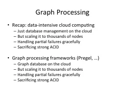
Graph Processing
by myesha-ticknor
Recap: data-intensive cloud computing. Just datab...
Map-Reduce Graph Processing
by karlyn-bohler
Adapted from UMD Jimmy Lin’s slides, which . is...
Lecture 2 MapReduce in brief
by Savageheart
Source. MapReduce. : Simplified Data Processing in...
M a p
by faustina-dinatale
R. e. d. u. c. e. . Simplified Data Processing o...
Big Data Infrastructure Week 5: Analyzing Graphs (2/ 2) This work is licensed under a Creative Commons Attribution-Noncommercial-Share Alike 3.0 United States
by sherrill-nordquist
Big Data Infrastructure Week 5: Analyzing Graphs...
Data-Intensive Distributed Computing Part 4: Analyzing Graphs (2/2)
by celsa-spraggs
Data-Intensive Distributed Computing Part 4: Anal...
Graph processing with PUMA
by essencemessage
Stijn Eyerman, Wim Heirman, Ibrahim Hur, Joshua B....
Interactive Motion Graphics
by alida-meadow
Week 05. TCNJ Dynamic Web Design. Jean Chu. Kinet...
Computer Graphics and Scientific Computing
by marina-yarberry
Thomas Sangild Sørensen. Course overview. Depart...
Running Map-Reduce Under Condor
by paige
Cast of thousands. Mihai. Pop. Michael Schatz. Da...
Other Map-Reduce (
by aaron
ish. ) Frameworks. William Cohen. 1. Outline. Mor...
Map-Reduce Abstractions
by yoshiko-marsland
1. Abstractions On Top Of . Hadoop. We’ve decom...
MapReduce
by liane-varnes
, Collective Communication, and Services. Oral Ex...
Speedup Graph Processing by Graph Ordering
by kittie-lecroy
Hao Wei. 1. , . Jeffrey Xu Yu. 1. , Can L. u. 1. ...
Methods for Creating Eye-Catching Window Graphics - Iris Signs
by irissigns
Window graphics are flexible and adaptable, making...
Graph Theory and Graph Coloring
by calandra-battersby
Lindsay Mullen. (Abstract) Algebra and Number The...
Chapter Multirate digital signal processing In multirate digital signal processing the sampling rate of a signal is changed in or der to increase the eciency of various signal processing operations
by jane-oiler
Decimation or downsampling reduces the sampling r...
Roadmap Graphics
by giovanna-bartolotta
– . Set (1 . of 2). Scott Kipp. March 8, 2016. ...
Roadmap Graphics
by ellena-manuel
– . Set (1 . of 2). Scott Kipp. March 8, 2016. ...
Microscope maps the graphene terrain
by debby-jeon
Janice E. . Reutt-Robey. , University of Maryland...
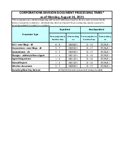
Processing time in business daysDate working Processing time in busine
by maisie
Arizona Corporation Commission Additional time ab...
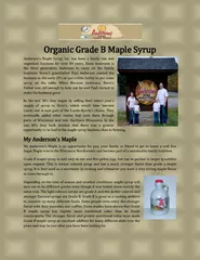
Organic Grade B Maple Syrup
by andersonsmaplesyrup
Anderson's Maple Syrup, Inc. has been a family run...
MapReduce : Simplified Data Processing on Large Clusters
by joyce
Jeffrey Dean & . Sanjay . Ghemawat. Appeared i...
Data Processing with MapReduce
by luanne-stotts
Yasin N. Silva and Jason Reed. Arizona State Univ...
Under the Hood of
by alida-meadow
Hadoop. Processing at OCLC Research. Code4lib 20...
10/30/2010 1 GRAPHICS PROCESSING UNIT
by phoebe-click
Shashwat Shriparv. dwivedishashwat@gmail.com. Inf...
5583Distributed Image Processing Using HIPI
by cora
1 INTRODUCTIONImage processing is the frequently u...
Electrochemically reduced graphene oxide sheets for us
by conchita-marotz
The electrochemically reduced graphene oxide ERGO...
Chapter 10: Big Data
by jensen206
Very large volumes of data being collected. Driven...
SOLUTIONS Exercises on
by sophia2
Block. 1:. Map-Reduce. Retrieval Evaluation. Cl...
A Hadoop MapReduce Performance Prediction Method
by ideassi
Ge. . Song. *. +. ,. . Zide. . Meng. *. ,. ....
Map-Reduce and the New Software Stack
by luanne-stotts
Mining of Massive Datasets. Jure Leskovec, . Anan...
The Buddhist who understood (your) Desire
by conchita-marotz
It’s not the consumers’ job to know what they...
MapReduce Online Tyson
by pamella-moone
Condie. UC . Berkeley. Slides by . Kaixiang. MO....
Load More...