Explore
Featured
Recent
Articles
Topics
Login
Upload
Featured
Recent
Articles
Topics
Login
Upload
Search Results for 'usgs river'
usgs river published presentations and documents on DocSlides.
Tom Weaver Eastern Hydrologic Data Chief
by brianna
Upper Midwest Water Science Center. . U.S. Geolo...
Hydrologic Measurement Precipitation
by ida
Evaporation. Streamflow. Channel . Properties. Top...
Hydrologic Measurement
by mitsue-stanley
Precipitation. Evaporation. Streamflow. Channel ....
River Channels CE 397 Flood Forecasting
by celsa-spraggs
David R. Maidment. Center for Research in Water R...
Fusion Team Brief Missouri Basin River
by jane-oiler
Forecasters’ . Meeting. Wednesday. , . January ...
Fusion Team Brief Missouri Basin River Forecasters’ Meeting
by giovanna-bartolotta
Kansas City, MO. Tuesday, 16 November 2010. USACE...
Cache River Monitoring 11-6000
by mitsue-stanley
Jennifer L. . Bouldin. , PhD. Ecotoxicology Resea...
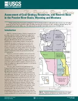
Powder River Basin KILOMETERS MILES East Gillette coal field extension Indian Reservations Montana Powder River Basin USGS OpenFile
by lindy-dunigan
S Department of the Interior US Geological Survey ...
The Yellowstone River
by sherrill-nordquist
Flooding in Glendive, MT. By: Clay Woods. Yellows...
Flooding
by debby-jeon
Coastal and River Flooding in Louisiana. What iss...
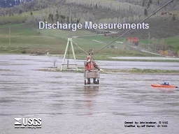
Discharge Measurements Created by: Jake Jacobson, ID WSC
by karlyn-bohler
Modified by: Jeff Kitchen, CA WSC. Control. Measu...
IWRSS & Fusion Team Brief
by min-jolicoeur
Missouri Basin River Forecasters’ Meeting. Wedn...
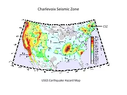
USGS Earthquake Hazard Map
by celsa-spraggs
Charlevoix Seismic Zone. CSZ. Source zones for th...
Stream Gages
by alida-meadow
CBRFC Stakeholder Forum. July 31, 2012. Stream Ga...
Observational
by stefany-barnette
. Uncertainties. in . Water-Resources. . Model...
Fort
by karlyn-bohler
Bend Flood Management Association. Flood Risk Red...
[ Flooding, Wicked Problems and the Limits of Predictabilit
by min-jolicoeur
Justin K. Weber. Goddard Earth Observing System M...
July 31, 2012
by tawny-fly
Kevin Werner. NWS Colorado Basin River Forecast C...
Load More...