PPT-USGS Earthquake Hazard Map
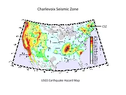
Charlevoix Seismic Zone CSZ Source zones for the Canadian seismic hazard map Includes all historical e arthquakes Mgt3 in the Geological Survey of Canada earthquake
Download Presentation
"USGS Earthquake Hazard Map" is the property of its rightful owner. Permission is granted to download and print materials on this website for personal, non-commercial use only, provided you retain all copyright notices. By downloading content from our website, you accept the terms of this agreement.
Presentation Transcript
Transcript not available.