/
P6.0 Information to NCARPO P6.0 Information to NCARPO

P6.0 Information to NCARPO - PowerPoint Presentation

sherrill-nordquist
sherrill-nordquist . @sherrill-nordquist
Follow
343 views
Uploaded On 2019-11-27

P6.0 Information to NCARPO - PPT Presentation

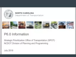
P60 Information to NCARPO Strategic Prioritization Office of Transportation SPOT NCDOT Division of Planning and Programming July 2019 2 Justin Green PE Prioritization Office SPOT Highway Mode ID: 768302

project calc prj cost calc project cost prj roadway spot highway cmt amp rail division ncdot safety runway lighting

Share:

Link:

Embed:

Download Presentation from below link

Download Presentation The PPT/PDF document "P6.0 Information to NCARPO" is the property of its rightful owner. Permission is granted to download and print the materials on this web site for personal, non-commercial use only, and to display it on your personal computer provided you do not modify the materials and that you retain all copyright notices contained in the materials. By downloading content from our website, you accept the terms of this agreement.


Presentation Transcript

P6.0 Information to NCARPO Strategic Prioritization Office of Transportation (SPOT)NCDOT Division of Planning and Programming July 2019

2 Justin Green, P.E. Prioritization Office (SPOT) Highway Mode (919) 707-4613jdgreen@ncdot.gov Jason Schronce, P.E. SPOT Manager Prioritization Office (SPOT) (919) 707-4646 jschronce@ncdot.gov Austin Chamberlain Prioritization Office (SPOT)TOP3S / GIS Support(919) 707-4650sachamberlain@ncdot.gov Sarah E. Lee Prioritization Office (SPOT) Non-Highway Modes (919) 707-4742 selee@ncdot.gov

P6.0 Schedule

P6.0 Schedule Changes 4 SURPRISE - STIP schedule extending to 3 years (a one-time change) Draft 2023-2032 STIP to be released January 2022P6.0 submittal window will still open early October 2019Will discuss schedule with Workgroup on August 5th to determine how to use extra time in P6.0 schedule

P6.0 Key Dates 2019 5 Completed: June 6 th – Anticipated BOT approval of P6.0 scoring June – Webinars with all partners to review P6.0 scoring changes Known Dates: October – SPOT Online opens for project entry (testing with P6 data) October – SPOT On!ine tutorials of submittal of all modes posted on Prioritization Resources websiteNovember – SPOT On!ine regional workshops with all partners to assist with individual project entry and testing needs

P6.0 Key Dates 2019 6 TBD by Workgroup Discussion: P6.0 Carryover deletions / modifications due P6.0 Highway Mobility Area-Specific Weights are due at close of submittal windowP6.0 Highway Modernization Area-Specific Weights are due at close of submittal windowP6.0 Primary Route Requests due to Mobility & Safety by close of submittal windowRegional Impact and Division Needs Local Input assignment periods

Submittal Pointers

Submittal Checklist 8 Read Submittal G uidance Documentation per mode Create/Enter project in SPOT On!ine “Submit” button after project entryStatus = single green checkComplete Identified Needs form Screen 8 in SPOT On!ineStatus = double green check Provide Complete Streets form (location TBD) Provide cost estimate documentation (if applicable…)

STI Law Eligibility Definitions   Mode Statewide Mobility Highway Interstates (existing & future) NHS routes (July 1, 2012) STRAHNET ADHS Routes Uncompleted Intrastate projects Designated Toll Facilities Aviation Large Commercial Service Airports ($500K cap) Bicycle -Pedestrian N/A Public Transportation N/A Ferry N/A Rail Freight Service on Class I Railroad Corridors Regional Impact Other US and NC Routes Other Commercial Service Airports not in Statewide ($300K cap) N/A Service spanning two or more counties (10% cap) Vessel or infrastructure expansion Rail service spanning two or more counties not in Statewide Division Needs All County (SR) RoutesFederal-Aid Eligible Local RoadsAll Airports without Commercial Service (General Aviation) ($18.5M cap)All projects ($0 state funds)All other service, including terminals and stationsReplacement vesselsAll other service, including terminals and stations (no short lines)

Other Fund Contributions 10 Benefit/Cost and Funding Leverage Timing of other fund contributions Other Fund contributions at the time of submittal get double impact: Lower “Cost to NCDOT” and Funding Leverage

New General Data Fields 11 Included in a Plan (and associated Name/Date) Original Submitter Organization that submitted the original projectSPOT will provide historical cross reference for your use on Carryover and Holding Tank projects

Highway 12 Definitions – Facility Type & Access Control

Highway 13 Logical termini Easiest method is looking at NCDOT AADT web maphttp://ncdot.maps.arcgis.com/home/webmap/viewer.html?webmap=b7a26d6d8abd419f8c27f58a607b25a1 Any project types where logical termini does not matter?Modernization Access Management What are not logical termini?County or jurisdictional boundariesWater crossings / Bridges Low volume intersections (in respect to the corridor)

14 SIT SIT SBF (% Reduction)SW REGDIV1 - Widen Existing Roadway 1.0 0 NCSTM NCSTM CALC 1A - Widen Existing Roadway - Add lane to Freeway 1.110NCSTM NCSTM CALC 1B - Widen Existing Roadway - Widen 2 lane roadway to 4 lane divided - Rural 1.2 55 NCSTM NCSTM CALC 1C - Widen Existing Roadway - Install two-way left turn lane on a two-lane roadway 1.3 20 NCSTM NCSTM CALC 1D - Widen Existing Roadway - Widen 2 lane roadway to 4 lane divided Superstreet with Partial Control of Access - Urban 1.4 15 NCSTM NCSTM CALC 1E - Widen Existing Roadway - Widen 2 lane roadway to 4 lane divided with Partial Control of Access - Urban 1.5 10 NCSTMNCSTMCALC 1F - Widen Existing Roadway - Widen 4 lane divided roadway to 6 lane divided - Urban1.615 NCSTMNCSTMCALC2 - Upgrade Arterial to Freeway/Expressway2.040NCSTMNCSTMCALC3 - Upgrade Expressway to Freeway3.025NCSTMNCSTMCALC4 - Upgrade Arterial to Superstreet4.035CMTCMTCMT5 - Construct Roadway on New Location5.0 0NCSTMNCSTMCALC 5A - Construct Roadway on New Location - Freeway Bypass5.110NCSTMNCSTMCALC 5B - Construct Roadway on New Location - Superstreet Bypass5.25NCSTMNCSTMCALC 5C - Construct Roadway on New Location - Multi-Lane Highway Bypass5.35NCSTMNCSTMCALC6 - Widen Existing Roadway and Construct Part on New Location6.0 0 NCSTM NCSTM CALC 6A - Construct Roadway on New Location - Freeway Bypass 6.1 10 NCSTM NCSTM CALC 6B - Construct Roadway on New Location - Superstreet Bypass 6.2 5 NCSTM NCSTM CALC 6C - Construct Roadway on New Location - Multi-Lane Highway Bypass 6.3 5 NCSTM NCSTM CALC 7 - Upgrade At-grade Intersection to Interchange or Grade Separation 7.0 40 CMT CMT CMT 8 - Improve Interchange 8.0 10 CMT CMT CMT 9 - Convert Grade Separation to Interchange 9.0 0 CALC CALC CALC 10 - Improve Intersection 10.0 25 CMT CMT CMT 10A - Improve Intersection - Roundabout 10.1 40 CMT CMT CMT 11 - Access Management 11.0 25 CALC CALC CALC 12 - Ramp Metering 12.0 5 CALC CALC CALC 13 - Citywide Signal System 13.0 5 CALC CALC CALC 14 - Closed Loop Signal System 14.0 15 CALC CALC CALC 15 - Install Cameras and DMS 15.0 0 CALC CALC CALC 16 - Modernize Roadway 16.0 20 CALC CALC CALC 17 - Upgrade Freeway to Interstate Standards 17.0 10 CALC CALC CALC 18 - Widen Existing Local (Non-State) Roadway 18.0 0 CALC CALC CALC 19 - Improve Intersection on Local (Non-State) Roadway 19.0 25 CMT CMT CMT 20 - Convert Grade Separation to Interchange to Relieve Existing Congested Interchange 20.0 0 CMT CMT CMT 21 - Realign Multiple Intersections 21.0 15 CMT CMT CMT 22 - Construct Auxiliary Lanes or Other Operational Improvements 22.0 10 CMT CMT CMT 23 - Construct Grade Separation at Highway / Railroad Crossing 23.0 90 CALC CALC CALC 24 - Implement Road Diet to Improve Safety 24.0 25 CALC CALC CALC 25 - Improve Multiple Intersections along Corridor 25.0 25 CALC CALC CALC 26 - Upgrade Roadway 26.0 20 CALC CALC CALC

Highway 15 Identifying corridor intersections in SPOT On!ine Extremely important for the cost estimation tool to give predictable results.

Aviation 16 Requesting component costs ROW, Utilities, Construction Requesting Source of CostNew Location and Airport Sponsor fieldsWork with your Airport Project Manager (APM) at the Division of AviationProject pre-screening, FAA purposeCorrect SIT (expanded capital eligibility)Inclusion in Airport Layout PlanPartner Connect Project Request Number (PRN)Cost

New to P6.0 17Remove P5.0 system plan goal requirement (for eligibility as a capital project) Expand eligibility to include projects that increase the capacity of the airport and/or modernize the airport Prescreening process – Division of Aviation to assist in screening and vetting projects prior to Prioritization submittal to ensure a better chance of meeting FAA approval of purpose and need

P5.0 Specific Improvement Types 18 0500 - Runway Length/Width 0535 - Runway Length: Taxiway Extension0540 - Runway Widening 0605 - Pavement Strength - Runway0610 - Pavement Strength - Taxiway0615 - Pavement Strength - Apron1100 - Taxiway Requirements1200 - Aircraft Apron / Helipad Requirements1240 - Corporate and T-hangar Taxiway: Construction1305 - General Aviation Terminal Building: New Construction1315 - General Aviation Terminal Building: Construct Addition to Existing1320 - General Aviation Terminal Building: Construct Terminal Access Road1325 - General Aviation Terminal Building: Construct non-revenue terminal public parking1900 - Hangars 2200 - Fuel Facilities 3005 - Other: Not otherwise defined in system plan objectives *Additional SITs for P6.0 – see next slide

P6.0 Specific Improvement Types 19 105 - Runway Approach: Land 110 - Runway Approach: Obstruction 205 - Runway Safety Area: Land 210 - Runway Safety Area: Construction 305 - Runway Protection Zones: Land/Obstruction 505 - Runway Length: Benefit Cost Analysis 510 - Runway Length: Environmental Assessment 515 - Runway Length: Land 520 - Runway Length: Preliminary Engineering 525 - Runway Length: Design 528 - Road/Infrastructure Relocation 530 - Runway Length: Construction 535 - Runway Length: Taxiway Extension 540 - Runway Widening 605 - Pavement Strength: Runway 610 - Pavement Strength: Taxiway 615 - Pavement Strength: Apron 805 - Runway Edge Lighting: Install System 810 - Runway Edge Lighting: Electrical Vault 815 - Runway Edge Lighting: Pilot Control Lighting 825 - Runway Edge Lighting: Relocate 1005 - SIAP: Feasibility Study 1010 - SIAP: Land 1015 - SIAP: Clearing/Survey 1020 - SIAP: Site Development 1025 - ILS Localizer / Glideslope 1030 - Distance Measuring Equipment (DME) 1035 - Non-Directional Beacon (NDB) 1040 - SIAP: Install Approach Lighting 1105 - Taxiway: Environmental Assessment 1110 - Taxiway: Design 1115 - Taxiway: Land 1120 - Taxiway: Preliminary Engineering 1125 - Taxiway: Construction 1205 - Apron / Helipad: Environmental Assessment 1210 - Apron / Helipad: Design 1215 - Apron / Helipad: Land 1220 - Apron / Helipad: Preliminary Engineering 1225 - Apron / Helipad: Construction 1230 - Apron / Helipad: Security Lighting 1235 - Apron / Helipad: Security Fencing 1240 - Corporate And T-Hangar Taxiway: Construction 1305 - GA Terminal Bldg: New Construction 1310 - GA Terminal Bldg : Upgrade Existing 1315 - GA Terminal Bldg : Addition To Existing 1320 - GA Terminal Bldg : Terminal Access Road 1325 - GA Terminal Bldg : Non-Revenue Terminal Public Parking 1330 - GA Terminal Bldg : Water/Sewer Utilities Construction 1405 - Lighting: Install Taxiway Edge Lighting, Vault 1410 - Lighting: Install Apron Edge Lighting 1415 - Lighting: Relocate Taxiway Edge Lighting 1420 - Lighting: Relocate Apron Edge Lighting 1505 - Airfield Signage: Install 1510 - Airfield Signage: Install (Lighted) 1705 - Approach Lighting: Install MALS/MALSF/MALSR 1710 - Approach Lighting: Rehab/Replace MALS/MALSF/MALSR 1715 - Approach Lighting: Install ODALS 1805 - ARFF: Eligible Fire Suppression Equipment 1810 - ARFF: Personnel Fire Protection Turn Out Gear 1905 - Hangars: Construction 1920 - Hangars: Access Road 2105 - Perimeter Fencing: Construction 2205 - Fuel Facilities: Construction 3005 - Other: Not Defined In System Plan Objectives

Bicycle/Pedestrian 20 Requesting component costs Preliminary Eng. / Design, ROW, Utilities, Construction Requesting Source of CostBike/Ped Cost Estimation ToolBreakdown of how to calculate local match (to include PE/Design)New Project Sponsor fieldBig P6.0 changes to prepare forManual points of interestTypes of connections to other bike/ped infrastructure (Existing, Committed, or Planned)Bundling of multiple project types and/or across geographies Reminder that POs will be requested to process Carryover projects in SPOT On!ine

Safety Benefit (based on new Facility Type) 21 BicycleSITPedestrianSITScoreNew Bicycle/Pedestrian Bridge, New Bicycle/Pedestrian Tunnel, Rail-Trail, Shared-Use Path / Multi-Use Path1, 2New Pedestrian Bridge, New Pedestrian Tunnel, Rail-Trail, Shared-Use Path / Multi-Use Path6, 7 7Buffered Bicycle Lane, Contra-Flow Bicycle Lanes, Separated Bike Lane, Sidepath2Sidepath, Sidewalk76Bicycle Lane3Sidewalk Widening, Trail Improvement 9 5 Paved Shoulder4 Crossing Island, Curb Extensions, Streetscape / Corridor Improvements 8,9 4Bicycle Detection / Actuation, Bicycle Signal, Curb Raddi Revisions, Hybrid Beacon, Intersection Markings / Signage, Lighting, Mid-Block Crossing5Accessible Pedestrian Signals, Curb Ramp, Lighting, Marked Crosswalk, Mid-Block Crossing, Pedestrian Hybrid Beacon, Pedestrian Signal, Rectangular Rapid Flashing Beacon83 Shared Lane Marking ("Sharrow"), Signage42Bicycle Corral, Bicycle Parking, Bicycle Share / Micro-Mobility Share, Bicycle Wheel Channel, Wayfinding5Wayfinding8 1

Ferry 22 Requesting component costs ROW, Utilities, Construction Requesting Source of CostNew Location fieldWork with Cat Peele at the Ferry DivisionProject needs to submitCost

Public Transportation 23 Requesting component costs Preliminary Eng. / Design, ROW, Utilities, Construction Requesting Source of CostBreakdown of how to calculate local match (to include PE/Design)New Location and Project Sponsor fieldsData clarifications:Most requested data is *annual* values (existing and additional trips, revenue hours, system hours)Additional values are projected for 10 years (2029)Guidance provided on all calculations (additional trips, service population around stops, facility data)Reminder that POs will be requested to process Carryover projects in SPOT On!ine

Rail 24 Requesting component costs ROW, Utilities, Construction Requesting Source of CostNew Location fieldWork with the Rail DivisionProject needs to submitCorrect STI categoryCostNew in P6.0 – ability to draw lines in SPOT On!ine for Freight and Passenger corridor projects

Specific Improvement Types 25 1 - Freight rail infrastructure improvement or construction (line) 2 - Freight rail infrastructure improvement or construction (point) 3 - Highway-rail crossing improvement (point)4 - Passenger rail station improvement or construction (point)5 - Passenger rail service (line)6 - Other passenger rail improvements (point)

Rail 26 Always choose to submit your Rail crossing project as a Rail SIT 3 (Highway-rail crossing improvement) Rail SIT 3HighwaySIT 23

Identified Needs Form for P6.0 Purpose: Capture “Why” project is submitted Info used to assist project scoring, cost estimate and NEPA/SEPA (if funded)  feeds Purpose & NeedRequired for all projects (all modes)Worked w/ Integrated Project Delivery (IPD) Team to developKeep form as simple as possible but capture requested infoNow integrated into SPOT On!ineDivisions (CDEs & DPEs) ultimately responsible for all formsCompleting forms = joint effort; Divisions will work with you on who initially fills out each form27

Identified Needs Form for P6.0 One tip on Category of Need (Highway) 28

Tools on Prioritization Resources Site 29 https://connect.ncdot.gov/projects/planning/Pages/PrioritizationResources.aspx Project Database Guidance and Submittals by Organization Local Input Points by Organization P6.0 Highway Testing Spreadsheet P5.0 Highway Projects for Area-Specific Weight Testing Spreadsheet Complete Streets Project Sheet *NEW* Bike-Ped Cost Estimation Tool (spreadsheet) Future spreadsheet and SPOT Online tutorial videos

SPOT Panel Q & A

SPOT Panel Q & A 31 Why was my project listed as a Regional Impact project but funded as a Division Needs?

32 40% of Funds 30% of Funds 30% of Funds Statewide Mobility Regional Impact Division Needs Focus  Address Local Needs Selection based on 50% Data & 50% Local Input Funding based on equal share for each Division (14) Focus  Address Significant Congestion and Bottlenecks Selection based on 100% Data Projects Programmed prior to Local Input Ranking Focus  Improve Connectivity within Regions Selection based on 70% Data & 30% Local Input Funding based on population within Region (7) How STI Works

SPOT Panel Q & A 33 My TAC doesn’t want to allow cascading of Statewide projects to Division Needs, how can I prevent a project from cascading?

SPOT Panel Q & A 34 I’ve always been confused about the Corridor Cap, can you explain in simple terms?

Corridor Cap 35 136-189.11, (d), (1), b: Project cap. – No more than ten percent (10%) of the funds projected to be allocated to the Statewide Strategic Mobility category over any five-year period may be assigned to any project or group of projects in the same corridor within a Highway Division or within adjoining Highway Divisions.

Corridor Cap 36

Corridor Cap 37 Project Cost Prj -C $50 M Prj -D $100 M Prj-E $150 MPrj-F$400 M Prj -G $150 M Total: 500 Million Project Cost Prj -A $200 M Prj -B $150 M Prj -C $50 M Prj -D $100 M Total: 850 Million Divisions 7 & 9 Divisions 7 & 5

Corridor Cap 38 (Dollars in Millions) Statewide Mobility Corridor Cap = 10% of sum highlighted $ (for each 5 yr period)

Corridor Cap 39 Project Cost Prj -C $50 M Prj -D $100 M Prj-E $150 MPrj-F$400 M Prj -G $150 M Total: 500 Million Project Cost Prj -A $200 M Prj -B $150 M Prj -C $50 M Prj -D $100 M Total: 850 Million Cap for 1 st 5 Years: $445,823,000 Divisions 7 & 9 Divisions 7 & 5

Corridor Cap 40

Corridor Cap 41 Project Cost Prj -C $50 M Prj -D $100 M Prj -E$150 MPrj-F$400 M Prj -G $150 M Total: 400 Million Project Cost Prj -A $200 M Prj -B $150 M Prj -C $50 M Prj -D $100 M Total: 750 Million Cap for 1 st 5 Years: $445,823,000 Divisions 7 & 9 Divisions 7 & 5

Corridor Cap 42

Corridor Cap 43 Project Cost Prj -C $50 M Prj -D $100 M Prj -E$150 MPrj-F $400 M Prj -G $150 M Total: 400 Million Project Cost Prj -A $200 M Prj -B $150 M Prj -C $50 M Prj -D $100 M Total: 350 Million Cap for 1 st 5 Years: $445,823,000 Divisions 7 & 9Divisions 7 & 5

Criteria Reference

45 P6.0 Hwy Criteria & Weights (Modernization Default) Statewide Mobility Congestion = 10% Safety = 25% Freight = 25% Lane Width = 10% Shoulder Width = 20% Pavement Condition = 10% ---- Funding Category QUANTITATIVE LOCAL INPUT Data Division MPO/RPO Regional Impact Congestion = 5% Safety = 25% Freight = 10% Lane Width = 10% Shoulder Width = 10% Pavement Condition = 10% Division Needs Safety = 20% Freight = 5% Lane Width = 5% Shoulder Width = 10% Pavement Condition = 10% 100% 70% 50% 25% 25%15%15% Note: Area-Specific Criteria Weights allowed

46 P6.0 Hwy Criteria & Weights (Mobility Default) Statewide Mobility Congestion = 30% Benefit-Cost = 25% Safety = 10% Freight = 25% Economic Comp. = 10% -- -- Funding Category QUANTITATIVE LOCAL INPUT Data Division MPO/RPO Regional Impact Congestion = 20% Benefit-Cost = 20% Safety = 10% Freight = 10% Accessibility/Connectivity = 10% Division Needs Congestion = 15% Benefit-Cost = 15% Safety = 10% Freight = 5% Accessibility/Connectivity = 5% 100% 70% 50% 25% 25% 15%15% Note: Area-Specific Criteria Weights allowed

Criteria Measure(s) Congestion SW: (60%) Volume/Capacity + (40%) VolumeREG: (80%) Volume/Capacity + (20%) Volume DIV: (100%) Volume/CapacityBenefit / Cost(Travel Time Savings $ + Safety Benefits $) / Cost to NCDOT+ Funding Leverage Safety Segments: (20%) Critical Crash Rate + (20%) Density + (20%) Severity + (40%) Safety Benefits Intersections: (30%) Frequency + (20%) Severity + (40%) Safety Benefits Economic Competitiveness(50%) Percent Change in Jobs + (50%) Percent Change in County EconomyAccessibility / Connectivity(50%) County Economic Indicator + (50%) Improve Mobility Freight (50%) Truck Volume + (50%) Truck Percentage + Future Interstate Completion Factor Highway Scoring – Criteria with P6.0 Measures

Criteria Measure(s) Multimodal Multimodal Benefits (Table Reference) Lane WidthExisting Width vs. Standard Width(Paved)Shoulder WidthExisting Width vs. Standard Width Pavement Score Pavement Condition Rating Highway Scoring – Criteria with P6.0 Measures

P6.0 Highway SITs 49 Highway Specific Improvement Types for P5.0 1 - Widen Existing Roadway 14 - Closed Loop Signal System 2 - Upgrade Arterial to Freeway/Expressway 15 - Install Cameras and DMS 3 - Upgrade Expressway to Freeway 16 - Modernize Roadway 4 - Upgrade Arterial to Superstreet 17 - Upgrade Freeway to Interstate Standards5 - Construct Roadway on New Location 18 – Widen Existing or Construct New Local (Non-State) Roadway 6 - Widen Existing Roadway and Construct Part on New Location 19 – Improve Intersection on Local (Non-State) Roadway- 7 - Upgrade At-grade Intersection to Interchange or Grade Separation 20 – Convert Grade Separation to Interchange to Relieve Existing Congested Interchange 8 - Improve Interchange 21 – Realign Multiple Intersections 9 - Convert Grade Separation to Interchange 22 – Construct Auxiliary Lanes or Other Operational Improvements 10 - Improve Intersection 23 - Construct Grade Separation at Highway / Railroad Crossing 11 - Access Management 24 – Implement Road Diet to Improve Safety 12 - Ramp Metering 25 – Upgrade Multiple Intersections 13 - Citywide Signal System 26 – Upgrade Roadway Primary scoring differences in Travel Time Savings & Safety Benefits

Aviation Scoring 50 Criteria Measure Statewide Mobility (100%) Regional Impact (70%) Division Needs (50%) NCDOA Project Rating NCDOA Project Rating 40% 30% 25% FAA ACIP Rating FAA Airport Capital Improvement Plan (ACIP) rating 30% 15% 10% Constructability Index Sum of metrics rating project constructability 10% 10% 5% Benefit/Cost (Total Economic Contribution / Cost to NCDOT) + Funding Leverage 20% 15% 10%

Bicycle & Pedestrian Scoring 51 Criteria MeasureDivision Needs (50%)Safety(Number of crashes x 40%) +(Crash severity x 20%) +(Safety risk x 20%) + (Safety benefit x 20%) 20% Accessibility / ConnectivityPoints of Interest pts +Connections pts + Route pts15%Demand/Density # of households and employees per square mile near project 10% Cost Effectiveness (Safety + Accessibility/Connectivity + Demand/Density) / Cost to NCDOT 5%

Ferry Scoring 52 Criteria MeasureRegional Impact (70%)Division Needs(50%)Asset Condition 100 - Asset Condition Rating 15% 15% Benefits Number of hours (in $) saved compared to driving 10% 10%Accessibility/Connectivity # of nearby Points of Interest 10% 10% Asset Efficiency 3-year maintenance cost / 3-year replacement cost 15% 15% Capacity/ Congestion % of vehicles left behind at each departure compared to total carried by the route 20% -

Criteria Measure Regional Impact (70%)Division Needs(50%) Impact Number of trips affected by project 15% 10% Demand/ Density Total Trips / Service population20%10%Efficiency Total trips / Total revenue seat hours10%10% Cost Effectiveness Additional trips / (Cost to NCDOT / Lifespan of project) 25% 20% Public Transportation Scoring: Mobility 53 Project Types: Route-specific vehicles (new or expansion only) Fixed guideway vehicles, fixed route vehicles, deviated fixed route vehicles Corridors Fixed guideway (commuter rail, intercity rail, light rail) Bundle of vehicle + other (ex. stops / shelters, park and rides, bus pullouts) Bus Rapid Transit (BRT) Bus on Shoulder System (BOSS) / Busway

Criteria Measure Regional Impact (70%)Division Needs(50%) ImpactNumber of trips affected by project10% 10% Demand/ Density Total hours with the project in place / Service population 20%15%Efficiency Vehicle Utilization Ratio 15%10%Cost Effectiveness Additional trips / (Cost to NCDOT / Lifespan of project) 25% 15% Public Transportation Scoring: Demand Response 54 Project Types: Demand Response vehicles (expansion only) No facilities – either submit Demand Response facilities under Facility category or under Mobility category if bundled with a vehicle

Criteria Measure Division Needs (50%) ImpactNumber of trips affected by project 15% Demand/ Density Ridership Growth Trend for the Previous 5 Years 10% EfficiencyEfficiency Score10% Cost EffectivenessAdditional trips /(Cost to NCDOT / Lifespan of project)15% Public Transportation Scoring: Facilities 55 Project Types: Passenger stations Individual or bundled stops/shelters Individual or bundled park and ride lots Administrative / Maintenance buildings

Rail Scoring *Only Class I Freight projects eligible in Statewide MobilityPassenger Rail only eligible for Regional Impact and Division Needs 56 Criteria Measure Statewide Mobility* (100%) Regional Impact (70%) Division Needs(50%) Benefit-Cost (Benefits / Cost to NCDOT) + Funding Leverage 35% 25% 1 0% System Opportunities (Accessibility/Connectivity score x 50 %) + (Multimodal score x 50%) 1 5% 1 0% 1 5 % SafetySARAH Investigative Indexx Mitigation Factor30%15%10%Capacity and Diversion(Volume/Capacity score x 75%) + (Highway Diversion score x 25%)10% 10%10%Economic CompetitivenessLong-term Jobs Createdx Unemployment Rate10%10%5%

Contact Information 57 https://www.ncdot.gov/sti spot@ncdot.gov (Jason, Sarah, Austin, Justin ) Jason Schronce, P.E. SPOT Manager Prioritization Office (SPOT) (919) 707-4646 jschronce@ncdot.govSarah E. Lee Prioritization Office (SPOT) Non-Highway Modes (919) 707-4742 selee@ncdot.gov Austin Chamberlain Prioritization Office (SPOT) TOP3s / GIS Support (919) 707-4650 sachamberlain@ncdot.gov Justin Green, P.E. Prioritization Office (SPOT) Highway Mode (919) 707-4613 jdgreen@ncdot.gov