/
Reporting Template for Land Use Reporting Template for Land Use

Reporting Template for Land Use - PDF document

sophia
sophia . @sophia
Follow
343 views
Uploaded On 2021-09-02

Reporting Template for Land Use - PPT Presentation

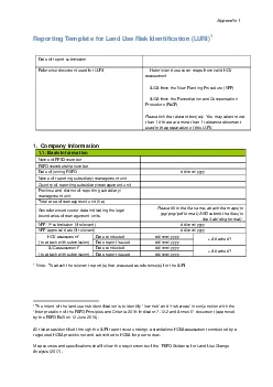
Appendix 1Risk IdentificationLURI1Date of report submissionReference document used for LURIx0000Historic land use cover maps from valid HCV assessment x0000LUCA from the New Planting Procedure NPPx000 ID: 875573

land risk date cover risk land cover date x0000 hcv 2018 yyyy area guidance rspo photo areas management nov

Share:

Link:

Embed:

Download Presentation from below link

Download Pdf The PPT/PDF document "Reporting Template for Land Use" is the property of its rightful owner. Permission is granted to download and print the materials on this web site for personal, non-commercial use only, and to display it on your personal computer provided you do not modify the materials and that you retain all copyright notices contained in the materials. By downloading content from our website, you accept the terms of this agreement.


Presentation Transcript

1 Appendix 1 Reporting Template for Land
Appendix 1 Reporting Template for Land Use Risk Identification (LURI) 1 Date of r e port s ubmission Reference document used for LURI � Historic land use cover maps from valid HCV assessment � LUCA from the New Planting Procedure (NPP) � LUCA from the Remediation and Compensation Procedure (RaCP) Please tick the relevant box(es). You may select more than 1 if there are more than 1 reference document used in the preparation of this LURI. 1. Company Information 1.1. Basic Information Name of RPSO member RSPO membership number Date of joining RSPO d d/mm/yyyy Name of reporting subsidiary/management unit Coun

2 try of reporting subsidiary/management
try of reporting subsidiary/management unit Province and district of reporting subsidiary/ management unit Total area of management unit (ha) Georeferenced vector data indicating the legal boundaries of management units Please fill in the file name, attach the maps (in jpg/png /pdf format) AND submit the files (in shp/tab/d wg format). NPP 1 st submission (if relevant) dd/mm/yyyy NPP approval date (if relevant) dd/mm/yyyy HCV assessment * (to attach with submission) Date conducted d d/mm/yyyy □ Attached? Date report issued d d/mm/yyyy LUC assessment * (to attach with submission) Date conducted d d/mm/yyyy □ Attached? Date

3 report issued d d/mm/yyyy * Note
report issued d d/mm/yyyy * Note: To attach the relevant report ( s ) that was used as reference (s) for the LURI 1 The intent of the land use risk identification is to identify “low risk” and “risk areas ” in conjunction with the “Interpretation of the RSPO Principles and Criteria 2018 : Indicator 7.12.2 and Annex 5 ” document (approved by the RSPO BoG on 12 June 2019). All risk areas identified through the LURI report must undergo a standalone HCSA assessment conducted by a registered HCSA practitioner and submitted to HC SA for peer review. Map sources and specifications shall follow the requiremen

4 ts of the ‘RSPO Guidance for Land Use Ch
ts of the ‘RSPO Guidance for Land Use Change Analysis (2017) . Appendix 1 2 . Result Guidance: Optional actions in cases where problems occur with satellite image(s) 2 : i. Cloud coverage: Use satellite images from other dates of acquisition with cloud coverage below 20% ii. Acquisition image not of good quality: Wherever possible, 1 - 3 months afterwards (or 6 months at the longest). The further the acquisition date, the larger the differences in land cover conditions. Please note that the images in Section 2.1 are example(s) of the information to be provided. 2.1 Data Comparison Table Remarks (if any): Remote sensing image Nov 2015 (insert date of satellite image

5 acquisition) Land cover classificatio
acquisition) Land cover classification Nov 2018 Land use risk identification Nov 2018 2 For more comprehensive guidance, please refer to ‘RSPO Guidance for Land Use Change Analysis (2017) . 1 Remarks (if any) : Remote sensing image Nov 2018 (insert date of satellite image acquisition) Land cover classification Nov 2018 Land use risk identification Nov 2018 2 2. 2 LU Risk Identification Guidance: The land cover classification and ID in the table below serve as examples of land cover class and are not fixed nor limited to those provided .

6 Land cover class and ID may be added an
Land cover class and ID may be added and/or removed based on the classification found in the LUCA and HCV assessment of the respective area . T he categorization of risk according to the land cover class are as below: a) Low risk – bare land, pasture, infrast ructure, agriculture or monocrop tree plantations which have not been abandoned � 3 years . b) Risk – land cover other than those identified as ‘low risk’ or ‘No go ‘areas . c) No go areas – HCV, peat, riparian areas, steep terrain , conservation areas . 3 ID Land cover class Area (Ha) Risk category (low risk/risk/No go) Total area (Ha) 2015 2018 Risk Low Risk No go R1 Secondary

7 Forest Risk R2 Shrub
Forest Risk R2 Shrub Risk LR1 Bare land Low risk LR2 Oil Palm Low risk LR3 Infrastructure Low risk LR4 Rubber plantation Low risk HCV HCV area No go HCV MA HCV management area No go CSA Conservation (e.g. peat etc.) No go Grand Total Remarks (if any): 3 Please refer to the RSPO Principles and Criteria (2018) Annex 1 for the definitions of steep terrain 3 2.4 Geo - tagged Site Photographs Guidance: Geotagged photograph needs to be taken as an evidence of grou

8 nd checking for each land cover class
nd checking for each land cover class identified and reported . Geotagged photos can be captured using smartphones (guidance on the use of smartphones for geo - tagging provided below):  iPhone: Launch Setting s -- � Privacy -- � Location Services -- � Camera -- � While Using the App  Android: Open camera app and tap on Settings. From the Settings, scroll down until you see the option “Geo tags” (or similar option) and enable it  Tutorial to enable geotagging: https://www.youtube.com/watch?v=TpCeOkw2QdY At least four photographs are required to ensure the entire landscape around the sample point is captured. Ideally the photos should b

9 e captured towards north, south, east a
e captured towards north, south, east and west direction. A folder containing the images to be submitted as annexure with the corresponding photo reference ID ID North South East West R1 Photo ID: Coordinates: 4 R2 Photo ID: Coordinates: LR1 Photo ID: Coordinates: 5 LR2 Photo ID: Coordinates: LR3 Photo ID: Coordinates: 6 LR4 Photo ID: Coordinates: 7 2. 5 Final LU Risk Identification map Insert final map ID Area (Ha) Remarks (if any) Risk Low Risk R1 R2 LR1 LR2 LR3 LR4 To