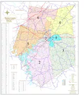
Purpose of MPOHT Technical Elements of MPOHT Update Project Schedule 2 1927 MNCPPC Founded 1932 First MPOH approved 1945 1st MPOH Update 1953 2nd MPOH Update 1955 3 rd ID: 783343
Download The PPT/PDF document "Briefing Outline History of Master Plan ..." is the property of its rightful owner. Permission is granted to download and print the materials on this web site for personal, non-commercial use only, and to display it on your personal computer provided you do not modify the materials and that you retain all copyright notices contained in the materials. By downloading content from our website, you accept the terms of this agreement.
Slide1
Slide2Briefing Outline
History of Master Plan of Highways & Transitways
Purpose of MPOHTTechnical Elements of MPOHT UpdateProject Schedule
2
Slide31927
M-NCPPC
Founded
1932
First MPOH
approved
1945
1st
MPOH Update
1953
2nd MPOH Update
1955
3
rd
MPOH Update (map only)
1974
Draft Mont. Co. MPOH* Update
2000,
2005 &
2010
Map Updates*
2013
Renamed to Master Plan of Highways & Transitways*
The Master Plan of Highways - a Map and Inventory showing all existing and proposed roadways – a “Highways” plan
3
History of the MPOHT
1
* “Within Montgomery County”
Slide4Last Comprehensive Study
1955
1955: Bi-County Master Plan of Highways was last updated comprehensively.
1956
: United States Interstate Highway System was authorized.
1956
: M-NCPPC boundary extended to include all Montgomery County (addition of Upper Montgomery planning area).1974: Montgomery County Only Plan initiated
4
History of the MPOHT
1
Slide5Last update –
2010 MPOHT
Static PDF mapInteractive tool in MCAtlas
viewer
webapp
No Master Plan Report
Living Functional Master Plan – amended frequently
5
History of the MPOHT
1
Slide6Guiding Montgomery County’s long-range transportation needs
Serving as a critical element in the master planning process
Preserving the right of way on county roadsPlanning for all transportation modesOrganizing planned transportation investments
Providing functional classification of roads and their rights of way
Requiring consistency with county code and design standards – context-sensitive and complete streets approach
MPOHT Purpose
6
2
Slide7Road widening
Planned roads
InterchangesTransitways (BRT and LRT) and stationsHOV lanes
Right of way needs along road corridors
7
MPOHT Purpose
2
Planned Transportation Investments
Slide8Functional Classification System
Mobility & access needs
Relationship to speedsVision Zero – speeds and conflicts contribute to poor road safety.
8
MPOHT Purpose
2
Slide9Consistency with Montgomery County Code
2007 Modifications – Context-sensitive design standards
2013 Modifications – Complete StreetsOlder plans need an update to be consistent with current standards
9
MPOHT Purpose
2
Slide10Initial highway-based plan
Guided by the General Plan (1964)
Amended by active and pending area master plansAmended by active and pending functional master plansMultimodal (since 2013) – Highways and Transitways
10
MPOHT Purpose
2
MPOHT Development
Slide11Major transportation corridors
Urban Ring
Wedges and Corridors
11
MPOHT Purpose
2
General Plan – Established Overall Focus
Slide12Functional Master Plans - Countywide
Countywide Corridors Functional Master Plan
Purple Line Functional Plan (including the Capital Crescent Trail)Rustic Roads Functional Master Plan
Bicycle Master Plan
Preservation of Agricultural & Rural Open Space
12
MPOHT Purpose
2
Slide13Area Master Plans
Initially organized by planning districts
Includes CBD sectors and corridors40+ active adopted master or sector plans currently in effect
5 pending area master plans: Rock Spring,
Veirs
Mill Road Corridor, MARC Rail Communities, Grosvenor-Strathmore, White Flint
Additional plans kicking off this summer/fall13
MPOHT Purpose
2
Slide14Multimodal Focus
2013 Countywide Transit Corridors Functional Master Plan
Officially changed the name of the plan from MPOH to MPOHT
14
MPOHT Purpose
2
Slide15Update road classifications based on Road Code adoption of new categories
Address inconsistencies with older plans
Update target speeds in urban road code areasRemove M-NCPPC Park Roads from MPOHT15
Technical Elements
3
Slide16Road Classifications added in 2007 Road Code
Road Classification Types
Controlled Major HighwaysMinor Arterial
Parkway
Design Characteristics for all Classifications
Target Speed
Access ControlLane Widths16
Technical Elements
3
Slide17Inconsistencies from Older Master Plans
Road classification changes at master plan boundaries
Missing/updated information in previous Master PlansSilver Spring CBD Business District Streets
Primary residential street numbering
New street names
Recognition of existing transportation investments including the I-270 HOV Lanes
17
Technical Elements
3
Slide182013 Road Code – Complete Streets
Urban Road Code – all county roads restricted to 25 mph target speed within the Road Code boundary
Many locations may not be in complianceProactive Urban Street Design according to NACTO (National Association of City Transportation Officials):
Target Speed = Design Speed = Posted Speed
18
Technical Elements
3
Slide19Removal of all M-NCPPC (Parks) Roads from MPOHT
Primary function of park roads – serve park users
ROW fully contained within Park property. ROW preservation in M–NCPPC control
Park roads may be used for commuting purposes as a secondary function
19
Technical Elements
3
Slide20Work Products
Countywide Master Plan of Highways and
Transitways
map
Master Plan document – companion document providing guidance on the Master Plan Map
Online and hard-copy
Mapbook providing zoomed-in details on every update in the plan. Improved web application using GIS technology with an outreach component and searchable functionalityWorking with the Communications Team on a strategic communications plan for messaging and deliverables
20
Technical Elements
3
Slide21MapBook
21
Technical Elements
3
Slide22MPOHT Feedback Map
Showing approximately 100 changes being proposed with this comprehensive update
Opportunity to comment online from August until November 2017 (during the countywide outreach effort)
Ability to provide comments using feedback map will continue be a part of the plan
Map will stay active for future comments
22
Technical Elements
3
Slide2323
Project Schedule
4
Slide24Schedule – Important Dates
Website Updates with GIS Tools –
August 2017Countywide Public Outreach Meetings – September-October 2017
Working Draft MPOHT to Planning Board –
November 2017
Submittal to County Executive & County Council –
March 2018Adoption by County Council – August 2018
24
Project Schedule
4
Slide25Community Meetings
September-October 2017
Five locations across the County 7 to 9 p.m.
Silver Spring
Bethesda/Chevy Chase
Rockville
BurtonsvilleGermantown
25
Project Schedule
4
Slide26Contact
Stephen Aldrich, Project Manager, (301) 495-4528,
Stephen.Aldrich@MontgomeryPlanning.org
Learn More:
http://montgomeryplanning.org/planning/transportation/highway-planning/2018-master-plan-of-highways-and-transitways/
26
Slide27Thank You
Questions
Discussion
27