/
ESS 202 ESS 202

ESS 202 - PowerPoint Presentation

tatyana-admore
tatyana-admore . @tatyana-admore
Follow
362 views
Uploaded On 2016-03-31

ESS 202 - PPT Presentation

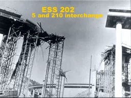
5 and 210 interchange Global tour of quakes California Rest of country Biggest quakes 1960 Chile 1964 Alaska 2004 Sumatra Rest of world Japan Turkey India 1755 Lisbon Big Cal quakes Mainly near San Andreas fault ID: 271999

fault quakes san quake quakes fault quake san 1906 big charleston earthquake 000 damage slip nevada madrid fire 1857

Share:

Link:

Embed:

Download Presentation from below link

Download Presentation The PPT/PDF document "ESS 202" is the property of its rightful owner. Permission is granted to download and print the materials on this web site for personal, non-commercial use only, and to display it on your personal computer provided you do not modify the materials and that you retain all copyright notices contained in the materials. By downloading content from our website, you accept the terms of this agreement.


Presentation Transcript

Slide1

ESS 202

5 and 210 interchangeSlide2

Global tour of quakesCaliforniaRest of country

Biggest quakes1960 Chile, 1964 Alaska, 2004 SumatraRest of world

Japan, Turkey, India

1755 LisbonSlide3

Big Cal quakes

Mainly near San Andreas faultA lot near Mendocino Triple JunctionRemember tectonics action at a triple junction

Some in the Sierra Nevada Mts.

Takes a large fault to have a magnitude 7+ earthquake

So magnitude 6’s have a wider distribution Slide4

San Andreas fault system

North

1857

1906

Red, yellow are fast-slipping faults,

yellow is intermediate, and

green and blue faults slip slowerSlide5

Significant California Earthquakes

1857 Fort

Tejon

1872

Owens Valley

1906

San Francisco

1933

Long Beach

1971

San Fernando

1989 Loma Prieta

1992 Landers1994 Northridge

1999 Hector Mines2004 ParkfieldSlide6

Bigquakes

inCal.

Bolt, 1.2

Northridge

San Fernando

Landers

Loma

Prieta

1906

SF

1857

LA

Hector

Mines

1872

Kern

1952

Kern

ParkfieldSlide7

1857 Fort Tejon Earthquake

This is a

“big one”Slide8

Felt in Santa Barbara

8:22 am, 2 fatalities near fault… universally noticed throughout the city, and was so violent in its vibrations that all of the inhabitants fled from their dwellings, the majority of whom, on bended knees, and hearts throbbing with terror, made fervent supplications that the imminent and impending danger might be providentially averted.

No damage to speak of in Santa BarbaraSlide9

A drawing of Mission Santa Cruz's Church after the 1857 earthquake.Slide10

A victim of the 1857 Fort Tejon earthquake on the San Andreas fault, this tree near Wrightwood had it's top snapped off, causing lower branches to grow vertically. Tree-ring dating has been used to accurately date past earthquakes.Slide11

1992 Landers Earthquake

June 28, 1992in Mojave DesertM

W

=7.5, largest since 1952

smaller than 1906 San Francisco

bigger than 1994 Northridge

70 by 12 km right-lateral, strike-slip rupture on vertical plane, lasted 20 sec

Displacement (offset, slip) up to 6 m

Connected 3 separate faults

didn’t know previously that they could rupture togetherSlide12

Fault plane slip mapSlide13

A record of the Landers quakeSlide14

Felt reports

from LandersSlide15

Landers fault trace

Fault scarp of 1992 Landers quake

Mw = 7.5

Right lateral strike-slip

Despite picture (thrust)

Up to 6 m of offsetSlide16

LandersscarpSlide17

Connected three separate faultsNot previously thought possible

Another Lesson:

Jumping Faults

Liu and SiehSlide18

1994 Northridge earthquake

4:31 AM, Jan. 17, 1994MW = 6.7, 20 by 20 km, 1-2 m slipReverse, thrust fault

Buried fault

focus at deepest part of fault (18 km)

rupture did not reach surface

on previously unknown fault

$40-50 billion damage

Still a few aftershocksSlide19

FeltreportsSlide20

Geologist’s cross-section

Arvid JohnsonSlide21

Topography across Los Angeles

NSlide22

Map view of aftershocks

NSlide23

Slip

Thrust faulting

Similar direction

Tapers at edges

Starts at bottomSlide24

North East

North East

South West

LA

Cross SectionSlide25

1971 San Fernando quake

M = 7.1, close to Northridge’s magnitudeJust a bit farther east than NorthridgeShook many Angelenos out of bed

It reminded us of problems

Unexpected damage to some modern buildings

Nearly breached a big dam

65 deaths, $500,000,000 in damage

It was well photographed

Will be featured in some future lecturesSlide26

Very Near Disaster

Nearly breached Lower Van Norman DamAt the intersection of 405 & 5

Evacuated 80,000Slide27

Highway buckling

http://www.ngdc.noaa.gov/cgi-bin/seg/m2h?seg/haz_volume1.men+Earthquakes+(General)+,I&10Slide28

Overpass

under

constructionSlide29

San Fernando Mall in 1971Slide30

Big one - 1906 San FranciscoSlide31

1906 San Francisco quake

3000 killed (6 shot for looting)

225,000/400,000 homeless

$400,000,000 loss, 20% of city’s value

Luckily, many buildings were steel frame

400 km rupture, 15 km deep, 5 m slip

M = 7.7, a “Big One”Slide32

Please don’triot anymore

(actually Turkey, 1999)Slide33

Likelydamage

patternSlide34

More about SF 1906

Fire was the biggest problemWater mains broken

Burned for three days

Stopped by dynamited fire breaks

Caused some new building codes

Cow-fell-in-a-crack hoaxSlide35

Liquefaction

Kovach, 3-9

Watsonville, 1906Slide36

Mercalli

intensity

pattern

1906 SF

Richter, 28-4Slide37

After quake, before fire

Bolt, 1-3

O’Farrell St., 1906Slide38

Palace

Hotel

in

San

FranciscoSlide39

Caruso stories and picturesSlide40

1906 SF Panorama- Part 1: Flames

Earthquake, fire, dynamiteSlide41

1906 SF Panorama- Part 2: Aftermath

Earthquake, fire, dynamiteSlide42

Escape from the fireSlide43

PostcardSlide44

Rats!Slide45

1933 Long Beach quake

5:54 pm, M = 6.3, near downtown

Timing lucky, since schools were hard hit

120 deaths, $50,000,000 in damage

A shock, people had forgotten about quakes

Led to key improvements in zoning

Field Act of 1933

Post-1933 buildings much safer than pre-1933Slide46

Area of damage

Richter, 28-14Slide47

1933 School DamageSlide48

Different School

Portland Cement Association

Jefferson Junior High School in Long BeachSlide49

Schools Damaged

Franklin Junior High School

Before

After

Photo: Historical Society of Long Beach via NISEE BerekelySlide50

Post OfficeSlide51

Not sure,but looks

bad.Slide52

1872 Owens Valley quake

M = 7.6 !! (big as a “Big One”)Devastated Lone PineStruck at 2:30 am

10% of 300 residents killed

90% of 60 adobe houses destroyed

Caused rockfalls across Sierra Nevada Mts.Slide53

Yanev, p. 200

Owens Valley

Intensity MapSlide54

Other US quakes

1959 Hebgen LakeM7.5 event in UtahNevada quakes

1915, 1932, three in 1954

1886 Charleston quake

1811-12 sequence of quakes in New MadridSlide55

Wasatch fault system

Nevada, Utah, and IdahoSome very large quakes

Less active than West Coast

Sparse population lessens damage

1959 Hebgen Lake quake

1954 Nevada sequence most notable

6.6

in July, followed by

6.4

11 hours later

6.8

in August

7.1 in December, followed by 6.8

4 minutes laterSlide56

Rest of US

Wasatch fault zoneUtah, Idaho, Montana, Wyoming

About 10-25% as active as San Andreas

Mainly normal faults

New Madrid

Had some big quakes

We don’t know how often they strike

Every 5000 years? Every 500?

Charleston

, plus a few others

We’ll talk about because of old quakes

Next one of my lecturesSlide57

Wasatch fault zoneSlide58

Basin and Range Topography

http://geography.sierra.cc.ca.us/booth/California/1_lithosphere/west_relief_map.jpgSlide59

1959 Hebgen Lake

Big scarpSlide60

Fault scarpSlide61

Traffic impedimentSlide62

Intensities for some Nevada quakes

Richter, 28-16

VI

VI

VI

IV

V

Pleasant Valley

Cedar Mountain

Dixie ValleySlide63

Scarp from 1954

Dixie Valley quake

Kovach, 3-8Slide64

AnotherSlide65

Big fault scarp

Richter, 28-21A

Fairview Peak, 1954Slide66

1886 Charleston quake

We still haven’t found the faultMagnitude about 7.3, $5M damage27 deaths? 60 deaths?This quake is an concern for public safety

Why quake there? Where next? When?

Claims of earthquake wavesSlide67

Yanev, p. 210

Charleston

isoseismsSlide68

Charleston damage

BoltSlide69

Charleston CollegeSlide70

House

in

CharlestonSlide71

Wild waves in Charleston in 1886?

Richter, p. 130Slide72

Train off tracksSlide73

1811-1812 New Madrid

M8 (M7.2, 7.0) December 1811M8 (M7.1) January 1812M8 (M7.4) February 1812Many other major quakes in this sequence

Felt across eastern United States

Used to be considered strongest historic events in US

Aside from AlaskaSlide74

New Madrid intensitiesSlide75

More New MadridMost evidence comes from river pilots, many boats were wrecked

Signs of quakes are subtle nowSubmerged cypress treesNew ridges that redirect river

Continuing aftershocks

Quakes broke a complicated set of faults

Recurrence time seems to be >5000 yearsSlide76
Slide77
Slide78

Regional seismicitySlide79

Zoom in to see “fault planes”Slide80

US map ofhistorical intensities

Eastern quakes have larger zones of shaking

Seismic waves travel farther in the east

Estimation of national quake danger

Can use historical pattern of quakes

Or can try to predict where future quakes will strikeSlide81

Intensity maps on national scale

Yanev, p. 210

VI & VII

VIII+Slide82

International quakes

Japan1923 Tokyo quake, horrific casualties1995 Kobe most expensive, $150 billion

China

- 1975 Haichang & 1976 Tangshan

Most fatalities, prediction experiment

India

- very active

Europe

- somewhat activeSlide83

Earthquakes M>5, 1963-1988

Keller, 1-5

Charleston

New Madrid

*

*

*

*

*

*

*

Quakes that we’ve discussed

Nevada

*

Related Contents


Next Show more