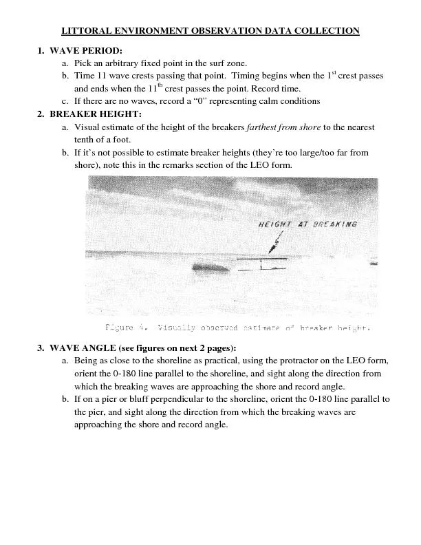
/
LITTORAL ENVIRONMENT OBSERVATION DATA COLLECTION LITTORAL ENVIRONMENT OBSERVATION DATA COLLECTION

LITTORAL ENVIRONMENT OBSERVATION DATA COLLECTION - PDF document

tatyana-admore
tatyana-admore . @tatyana-admore
Follow
391 views
Uploaded On 2016-06-22

LITTORAL ENVIRONMENT OBSERVATION DATA COLLECTION - PPT Presentation

Pick an arbitrary fixed point in the surf zone Time 11 wave crests passing that point Timing begins when the 1If there are no waves record a ID: 372570

Pick arbitrary fixed point

Share:

Link:

Embed:

Download Presentation from below link

Download Pdf The PPT/PDF document "LITTORAL ENVIRONMENT OBSERVATION DATA CO..." is the property of its rightful owner. Permission is granted to download and print the materials on this web site for personal, non-commercial use only, and to display it on your personal computer provided you do not modify the materials and that you retain all copyright notices contained in the materials. By downloading content from our website, you accept the terms of this agreement.


Presentation Transcript

LITTORAL ENVIRONMENT OBSERVATION DATA COLLECTION Pick an arbitrary fixed point in the surf zone. Time 11 wave crests passing that point. Timing begins when the 1If there are no waves, record a “0” representing calm conditions BREAKER HEIGHT: farthest from shoretenth of a foot. If it’s not possible to estimate breaker heights (they’re too large/too far from rks section of the LEO form.WAVE ANGLE (see figurescal, using the protractor on the LEO form, eline, and sight along the direction from horeline, orient the 0-180 line parallel to WAVE TYPES: WIND SPEED: Hold wind meter slightly above head level, and slowly rotate until maximum wind speed is found. WIND DIRECTION: Using a compass, note which direction the maximum wind speed is blowing from. On the part of the beach wetted by the wave uprush, lay flat surface (2X4 or similar) on the upper wetted part of the swWIDTH OF SURF ZONE: Visually estimate the distance from the shoreline (upper limit of the wetted part of the beach) to the seawardmost line of 9.LONGSHORE CURRENT: Dye DistanceThrow dye packet into surf zone between the shoreline and the outermost . If possible, just landward of the Estimate the distance from the shoreline to the point of dye injection. timing the dye movement to determine current speed. Then, parallel to the shoreline, pace off the distance the dye traveled in 1 minute. Convert paces to feet, and Facing seaward, if the dye moves to the right, record a “+1”, if the dye moves to the left, record a “-1”. If no movement occurs, or if the dye moveIf the dye moves seaward, note it in the remarks section. RIP CURRENTS: If rip currents are observed, estimate recorded in feet on the form. BEACH CUSPS: acing between the mounds is and record the distance the form.