/
Module  3.2 Data  and guidance on developing REDD+ reference levels Module  3.2 Data  and guidance on developing REDD+ reference levels

Module 3.2 Data and guidance on developing REDD+ reference levels - PowerPoint Presentation

tawny-fly
tawny-fly . @tawny-fly
Follow
343 views
Uploaded On 2019-11-23

Module 3.2 Data and guidance on developing REDD+ reference levels - PPT Presentation

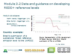
Module 32 Data and guidance on developing REDD reference levels Module developers Martin Herold Wageningen Univ Erika Romijn Wageningen Univ Sandra Brown Winrock International Country example ID: 767396

unfccc forest emission frl forest unfccc frl emission submission reference data brazil

Share:

Link:

Embed:

Download Presentation from below link

Download Presentation The PPT/PDF document "Module 3.2 Data and guidance on develo..." is the property of its rightful owner. Permission is granted to download and print the materials on this web site for personal, non-commercial use only, and to display it on your personal computer provided you do not modify the materials and that you retain all copyright notices contained in the materials. By downloading content from our website, you accept the terms of this agreement.


Presentation Transcript

Module 3.2 Data and guidance on developing REDD+ reference levels Module developers:Martin Herold, Wageningen Univ.Erika Romijn, Wageningen Univ.Sandra Brown,Winrock InternationalCountry example:Brazil’s submission of a subnational forest reference emission level to the UNFCCC Forest emissions (MtCO 2 ) Time ---  V1, May 2015 Figure: Representation of FRL development for Brazil. Source : GOB 2014, Brazil’s submission of FRL to UNFCCC. Creative Commons License

Brazil’s submission of a subnational forest reference emission level to the UNFCCC Subnational FRL:Selected region: AmazoniaSelected activity: deforestationSelected pools: aboveground biomass, belowground biomass, litterEventually the national FRL will consist of the sum of subnational FRLs for six biomesFRL for degradation is under construction

Brazil’s submission of a subnational forest reference emission level to the UNFCCC Submission follows the guidelines from UNFCCC (2012, Decision 12 / CP17, part 2, annex). Submission includes:Information that was used in constructing the FRLTransparent, complete, consistent, and accurate information, including methodological information, used at the time of construction of FRLs, including a description of datasets, approaches, and methods Pools and gases, and activities that have been included in the FRL The definition of forest used in construction of the FRL

1. Information that was used in constructing the FRLApproach 3 activity data: annual deforestation polygons based on analysis of Landsat satellite data (30 m. res.)Emission factors for each distinct forest typeYearly calculation of CO2 emissions from 1996-2010:GEt = total emission from gross deforestation at year t (in tonnes CO 2)GEi,j = CO2 emission associated with deforested polygon i under forest type j (in tonnes CO2)N = number of new deforested polygons in year tp = number of forest types

1. Information that was used in constructing the FRL FRL reflects dynamic mean of annual CO2 emissions and is updated every five yearsSource: GOB 2014, Brazil’s submission of FRL to UNFCCC. Time ---  Forest emissions (MtCO 2 )

2. Transparent, complete, consistent, and accurate informationTransparency:Detailed description of all data, methods, and productsCompleteness:All satellite images, data, and products availableConsistency:Same methods and data used to estimate and report emissions in the national greenhouse gas (GHG) inventory and to construct the FRLAccuracy:AD: use of Landsat data with high accuracyEF: still many uncertainties in the data

3. Pools and gases, and activities included in FRL developmentPools:Aboveground biomassBelowground biomassLitterGases:CO2 emissionsActivity:Deforestation

4. The definition of forest used in construction of the FRLFood and Agriculture Organization definition of forest:Land > 0.5 hectareTrees > 5 metersCanopy cover > 10%Deforestation = clear-cut based on total tree cover loss within the minimum mapping unit of 6.25 hectares (250 x 250 m)Other types of loss, where the canopy thresholds stays over 0%, are regarded as forest degradation

Recommended modules as follow-up Module 3.3 to continue with guidance on reporting REDD+ performance using IPCC Guidelines and Guidance

References GOB (Government of Brazil). 2014. Brazil’s Submission of a Forest Reference Emission Level for Deforestation in the Amazonia Biome for Results-based Payments for REDD+ under the UNFCCC. 2014. Brazília. https://unfccc.int/files/land_use_and_climate_change/redd/application/pdf/20140606_submission_frel_brazil.pdf.IPCC, 2003. 2003 Good Practice Guidance for Land Use, Land-Use Change and Forestry, Prepared by the National Greenhouse Gas Inventories Programme, Penman, J., Gytarsky, M., Hiraishi, T., Krug, T., Kruger, D., Pipatti, R., Buendia, L., Miwa, K., Ngara, T., Tanabe, K., Wagner, F. (eds.). Published: IGES, Japan. http://www.ipcc-nggip.iges.or.jp/public/gpglulucf/gpglulucf.html (Often referred to as IPCC GPG)UNFCCC (United Nations Framework Convention on Climate Change). 2014. Decision 13/CP.19. Guidelines and procedures for the technical assessment of submissions from parties on proposed forest reference emission levels and/or forest reference levels. http://unfccc.int/resource/docs/2013/cop19/eng/10a01.pdf#page=34.

UNFCCC. 2012. Decision 12/CP.17. Report of the Conference of the Parties on its seventeenth session, held in Durban from 28 November to 11 December 2011: Part Two: Action taken by the Conference of the Parties at its seventeenth session. http://unfccc.int/resource/docs/2011/cop17/eng/09a02.pdf#page=16. UN-REDD. 2014. Emerging Approaches to Forest Reference Emission Levels and/or Forest Reference Levels for REDD+. Rome: Food and Agriculture Organization. www.unredd.net/index.php?option=com_docman&task=doc_download&gid=13473&Itemid=53.