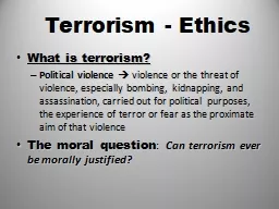
An Assessment Hawk McMahon Alison Regan Noel Dyer Outline Washington DC Sectors of Primary Concern Government Public Spaces Critical Infrastructure Methodology Analytical Geographic Future Work and Research ID: 630040
Download Presentation The PPT/PDF document "Potential Terrorism Targets in Washingto..." is the property of its rightful owner. Permission is granted to download and print the materials on this web site for personal, non-commercial use only, and to display it on your personal computer provided you do not modify the materials and that you retain all copyright notices contained in the materials. By downloading content from our website, you accept the terms of this agreement.
Slide1
Potential Terrorism Targets in Washington, DC
An
Assessment
Hawk McMahon, Alison Regan, Noel DyerSlide2
Outline
Washington, DC
Sectors of Primary Concern
GovernmentPublic SpacesCritical InfrastructureMethodologyAnalytical GeographicFuture Work and Research
Image courtesy DC GIS Open Data 2016Slide3
Washington, DCSlide4
Government
Washington D.C. hosts high value government targets critical to Federal governance, exhibits international visibility, and is home to a large metropolitan population.
A successful attack in this region could potentially achieve the desired outcomes of multiple terrorist organizations:
economic damagemilitary damagemorale boosts of terrorist organizationsdiffusion of panicSlide5
Government
Highest value targets are the upper echelon of government and by extension, the locations they most frequent
President and the cabinet, the House of Representatives, the Senate, leaders of intelligence agencies, heads of infrastructure management departments, diplomats, and high ranking military officials.
White House, Congress, Pentagon, FBI, Government departments, embassies, and military installations.Main Executive and Legislative Offices and Military Installations in Washington, D.C.
Google Maps 2016Slide6
Government
Highest value targets are the upper echelon of government and by extension, the locations they most frequent
President and the cabinet, the House of Representatives, the Senate, leaders of intelligence agencies, heads of infrastructure management departments, diplomats, and high ranking military officials.
White House, Congress, Pentagon, FBI, Government departments, embassies, and military installations.Embassy Locations
Image courtesy DC GIS Open Data 2016Slide7
Public Spaces
DC is also a major tourist attraction and hub for academia
Vulnerable “Soft Targets”
These locations are often highly visible with easy access, have a high number of visitors and attendees, and have significant symbolic value in the United States.Loss of lifeDamage to the economyPanicDecrease confidence in the government and security of the United StatesSlide8
Public Spaces
“Points
of Interest”
Image courtesy DC GIS Open Data 2016Slide9
Public Spaces
Some of the most visible and visited in Washington:
Iconic/Hallmark Sites
National MonumentsThe National MallThe Smithsonian Institution, MuseumsEntertainment Verizon CenterKennedy CenterNational Theater
Nat’s ParkGeneral (Movies, Restaurants, etc.)
Universities
George Washington
American
Special Events
Parades, Festivals, etc
.Slide10
Critical Infrastructure
Direct and indirect method of attack on the population and government services
Transit
High volume of use, known location, predictable schedulePorous entry points are necessary for its purposeFinancial ServicesHistory of targetting by internation and domestic terroristsHigh propoganda / social media impact given proximity to US President
WMATA 2016Slide11
Critical Infrastructure
Utilties / Telecommunications
DC is the “head” of the country
More than just the Commander in ChiefCoordination and Leadership is vital for response to wide spread attack as well as merely maintaining regular daily functions..Cyber and Physical threatsDC GIS Open Data 2016Slide12
Critical Infrastructure
Utilties / Telecommunications
DC is the “head” of the country
More than just the Commander in ChiefCoordination and Leadership is vital for response to wide spread attack as well as merely maintaining regular daily functions..Cyber and Physical threatsDC GIS Open Data 2016Slide13
Critical Infrastructure
Mass Transportation
Metro Rail
Highway Bridges
Roosevelt
, Arlington
Memorial,
14
th
Street,
and
I-495
DCA
Amtrak
Finance
(private and government)
K-Street
Internal Revenue Service
Social Security Administration
Utilities / Telecommunications
WMATA 2016
@jshinkle 2015 via Twitter
Google Street View 2016
DC GIS Open Data 2016Slide14
Methodology
Analytical
Diagnostic: Key Assumptions Check, Mindset Check,
Quality of Information Check, Analysis of Competing HypothesisCoherent picture and background across the teamContrarian: What-If (example: suicide bomb detonation morning rush hour orange line)Imaginative: Brainstorming, Red Team AnalysisEvent Review Geographic/Cartographic ProductsHot Spot / Chokepoint Analysis
Map Story – Red CellSlide15
Methodology
g
raphic courtesy Dr. A. Stefanidis GMU
2015Slide16
Methodology
First Pass ACHSlide17
Methodology
Map Story – Red Cell Operations PlanCriteria: 10 people $100,000 budget9/11 Commission Report“To plan and conduct their attack, the 9/11 plotters spent … approximately $300,000… Their primary expenses consisted of tuition for flight training, living expenses…and travel” (Kean ,2004)Paris Attacks as a more recent model
Demonstrates:Risk of this level of open source informationHow accurate/professional a plan can be made by terrorists
Realistic Scenario that Emergency Response would have to handle
Red CellSlide18
Questions ?