/
Wrangell-St. Elias National Park & Preserve Wrangell-St. Elias National Park & Preserve

Wrangell-St. Elias National Park & Preserve - PDF document

trish-goza
trish-goza . @trish-goza
Follow
408 views
Uploaded On 2016-02-29

Wrangell-St. Elias National Park & Preserve - PPT Presentation

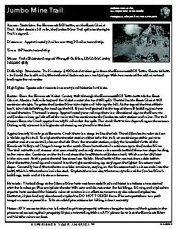
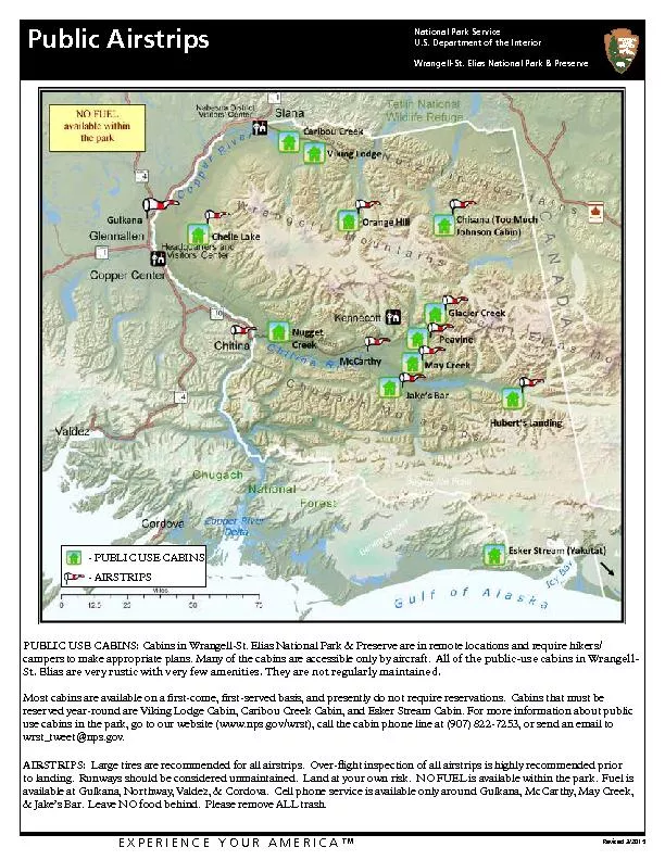
Public Airstrips EXPERIENCE YOUR AMERICA153 Revised 32015 PUBLIC USE CABINS Cabins in WrangellSt Elias National Park Preserve are in remote locations and require hikerscampers to make approp ID: 235491

Public Airstrips EXPERIENCE YOUR AMERICA™ Revised 3/2015 PUBLIC

Share:

Link:

Embed:

Download Presentation from below link

Download Pdf The PPT/PDF document "Wrangell-St. Elias National Park & Prese..." is the property of its rightful owner. Permission is granted to download and print the materials on this web site for personal, non-commercial use only, and to display it on your personal computer provided you do not modify the materials and that you retain all copyright notices contained in the materials. By downloading content from our website, you accept the terms of this agreement.


Presentation Transcript

Wrangell-St. Elias National Park & Preserve Public Airstrips EXPERIENCE YOUR AMERICA™ Revised 3/2015 PUBLIC USE CABINS: Cabins in Wrangell-St. Elias National Park & Preserve are in remote locations and require hikers/campers to make appropriate plans. Many of the cabins are accessible only by aircraft. All of the public-use cabins in Wrangell-St. Elias are very rustic with very few amenities. They are not regularly maintained.Most cabins are available on a rst-come, rst-served basis, and presently do not require reservations. Cabins that must be reserved year-round are Viking Lodge Cabin, Caribou Creek Cabin, and Esker Stream Cabin. For more information about public use cabins in the park, go to our website (www.nps.gov/wrst), call the cabin phone line at (907) 822-7253, or send an email to wrst_tweet@nps.gov.AIRSTRIPS: Large tires are recommended for all airstrips. Over-ight inspection of all airstrips is highly recommended prior to landing. Runways should be considered unmaintained. Land at your own risk. NO FUEL is available within the park. Fuel is available at Gulkana, Northway, Valdez, & Cordova. Cell phone service is available only around Gulkana, McCarthy, May Creek, & Jake’s Bar. Leave NO food behind. Please remove ALL trash. - AIRSTRIPS Location: Orange Hill. No FAA identier. N62.212042, W142.848128Description: 700’ gravel airstrip. This airstrip is located in the Nabesna River valley, approximately 13 miles southeast of Nabesna. CAUTION: Airstrip is being heavily eroded and shortened each summer by a bend of the Nabesna River! Wrangell-St. Elias National Park & Preserve Orange Hill Airstrip Location: Chisana (CZN). Located 97 nautical miles east of the Gulkana airport, in the historic mining settlement of Chisana. Description: CTAP 122.91600 foot gravel airstripElevation 3318 feetPublic tie-downs are available. Two other private, but active airstrips are in the vicinity. Please respect private property in the area. Wrangell-St. Elias National Park & Preserve Chisana Airstrip (CZN) Location: McCarthy Nr2 (15Z). McCarthy is located approximately 85 nautical miles south east of Gulkana. Description: CTAF 122.9Elevation 1531 ftMcCarthy is accessible by aircraft, or a 59-mile gravel road. Public tie-downs at the airstrip are available. Aircraft owners are allowed to camp under the wings of the aircraft, but there are NO campres allowed on the ramp. There are phones, food, and lodging available in Kennecott and McCarthy during the summer. The town of McCarthy is 1 mile south of the airport. Kennecott is located 3.5 miles north of the airport. During summer months, commercial shuttles are available to both of these locations. Please respect private property in the area. Wrangell-St. Elias National Park & Preserve McCarthy Airstrip Location: Glacier Creek (KGZ). This airstrip is situated 18 miles east of McCarthy, about 1/2 mile south of the Chitistone River. Description:CTAF 122.9Elevation 2380’Avoid ying in valley during strong winds. Tie downs are available. NOT RECOMMENDED FOR TRI-CYCLE GEAR AIRCRAFT. Wrangell-St. Elias National Park & Preserve Glacier Creek Airstrip (KGZ) Location: Peavine Bar. No FAA identier. Airstrip is located 14 miles east of McCarthy on a gravel bar of the Chitistone River.Description:CTAF 122.91650’ X 25’ gravel airstripElevation ~2000NOT RECOMMENDED FOR TRI-CYCLE GEAR AIRCRAFT. Avoid ying in valley during strong winds. Public tie-downs are available. Wrangell-St. Elias National Park & Preserve Peavine Bar Airstrip Location: May Creek (MYK). This airstrip is located between May and Chititu Creek, approximately 11.5 miles southeast of McCarthy. N61 20.14 W142 41.21Description:CTAF 122.9Elevation 1,650’Airstrip is turf and is 2,700’ feet long. Public tie-downs are available on the southeast end of the airstrip. The airstrip is frequently used as a staging area and may have other users. Wrangell-St. Elias National Park & Preserve May Creek Airstrip (MYK) Location: Jake’s Bar (AKO). This airstrip is situated on the north shore of the Chitina River about 15 miles south of McCarthy. Description:CTAF 122.9Elevation 1052’Airstrip is 1000’ feet long. NOT RECOMMENDED FOR TRI-CYCLE GEAR AIRCRAFT. Public tie-downs are available. Wrangell-St. Elias National Park & Preserve Jake’s Bar Airstrip (AKO) Location: Hubert’s landing. No FAA identier. 61.027, -141.631. Airstrip is located on the upper Chitina River.Description: Very rough gravel airstrip 900’ long. It is situated on an alluvial plain. Wrangell-St. Elias National Park & Preserve Hubert’s Landing Airstrip