Earth Global Reference Atmospheric Model (GRAM) Overview and Future Improvements COSPAR 2021 Patrick White NASA, Marshall Space Flight Center, Huntsville, AL Natural Environments Earth-GRAM Lead Outline Overview Benefits to using Earth-GRAM
"Earth Global Reference Atmospheric Model (GRAM)" is the property of its rightful owner. Permission is granted to
download and print the materials on this website for personal, non-commercial use only, and to display it
on your personal computer provided you do not modify the materials and that you retain all copyright
notices contained in the materials. By downloading content from our website, you accept the terms of this
agreement.
Presentation Transcript
01
Earth Global Reference Atmospheric Model (GRAM) Overview and Future Improvements COSPAR 2021 Patrick White
NASA, Marshall Space Flight Center, Huntsville, AL Natural Environments
Earth-GRAM Lead<br>
02
Outline Overview
Benefits to using Earth-GRAM
Current Status
Upgrade Plans
Hourly Comparison to Wind Pairs Databases
Modern-Era Retrospective Analysis for Research and Applications, Version 2 (MERRA-2) Implementation
Boundary Layer Improvement Study 2<br>
03
Overview Earth Global Reference Atmospheric Model (Earth-GRAM) provides monthly mean and standard deviation for any point in the atmosphere
Includes Monthly, Geographic, and Altitude Variation
Atmospheric variables output included: pressure, density, temperature, horizontal and vertical winds, speed of sound, and atmospheric constituents
Used by engineering community because of ability to create dispersions in the atmosphere at a rapid runtime
Often embedded in trajectory simulation software
Earth-GRAM is not a forecast model
Does not readily capture localized atmospheric effects 3<br>
04
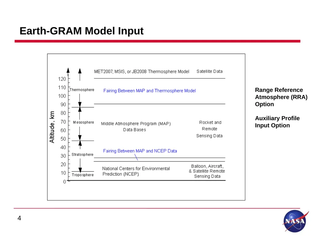
Earth-GRAM Model Input 4 Range Reference Atmosphere (RRA) Option
Auxiliary Profile Input Option<br>
05
Range Reference Atmosphere (RRA) Database and Auxiliary Profile Option Earth-GRAM has the ability to use the RRA site specific databases
Earth-GRAM includes 1983, 2006 and 2013 RRA databases
15 2013 RRA sites developed by MSFC/Natural Environments Branch for the Range Commanders Council – Meteorology Group
Climatology built from balloon and rocketsonde measurements
MSFC - Natural Environments recommends the use of the 2013 RRA database
Natural Environment’s has recently developed 2019 RRA database
Plan to implement in Earth-GRAM
Auxiliary Profile option allows users the option to include profile of their choice 5<br>
06
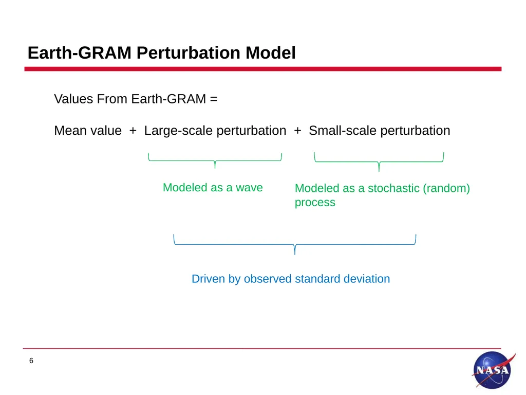
Values From Earth-GRAM =
Mean value + Large-scale perturbation + Small-scale perturbation Modeled as a stochastic (random) process Modeled as a wave Earth-GRAM Perturbation Model 6<br>
07
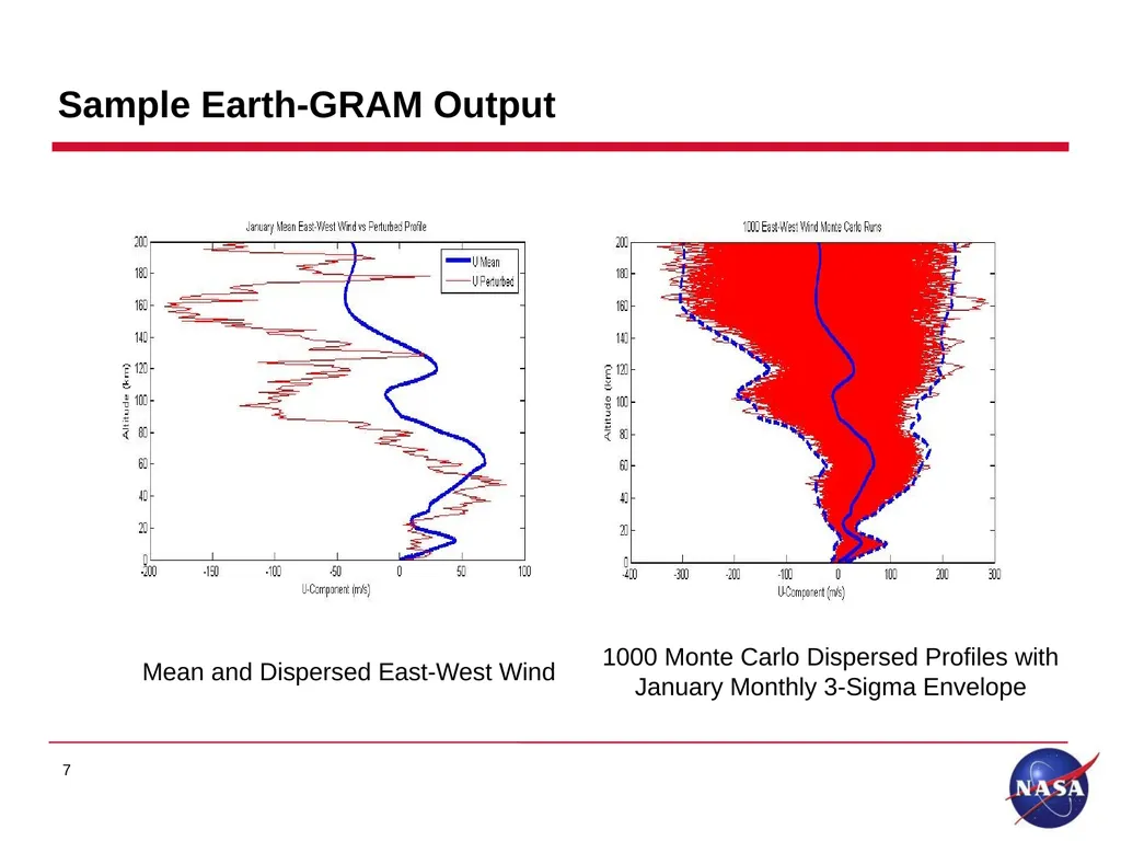
Sample Earth-GRAM Output Mean and Dispersed East-West Wind 1000 Monte Carlo Dispersed Profiles with
January Monthly 3-Sigma Envelope 7<br>
08
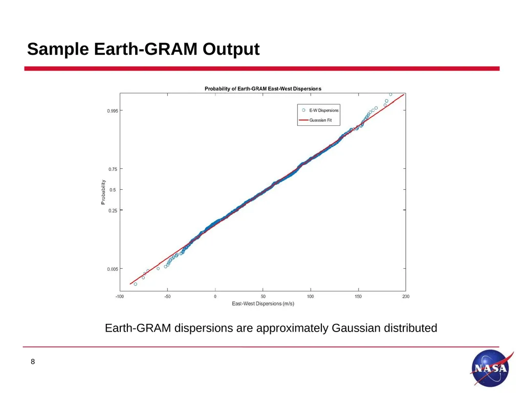
Sample Earth-GRAM Output Earth-GRAM dispersions are approximately Gaussian distributed 8<br>
09
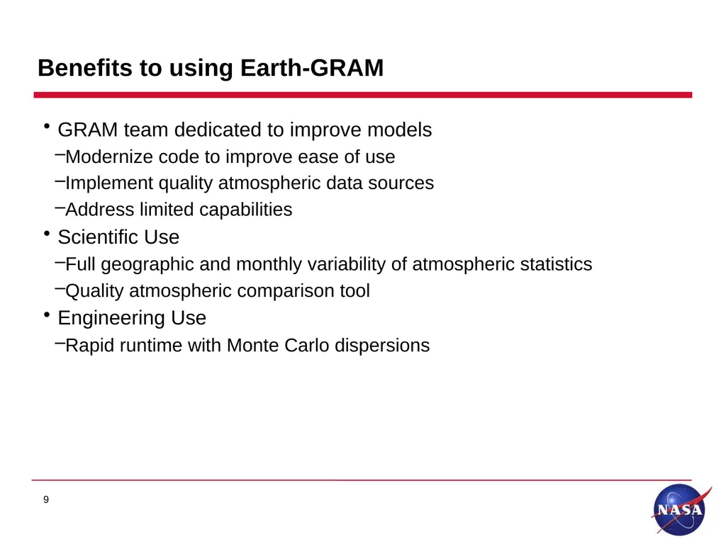
Benefits to using Earth-GRAM GRAM team dedicated to improve models
Modernize code to improve ease of use
Implement quality atmospheric data sources
Address limited capabilities
Scientific Use
Full geographic and monthly variability of atmospheric statistics
Quality atmospheric comparison tool
Engineering Use
Rapid runtime with Monte Carlo dispersions 9<br>
10
Current Status Currently Releasing Earth-GRAM 2016 Version 2.0
C++ object oriented software
Ability to incorporate code in multi-body trajectory simulations
Includes ability to produce hourly atmosphere dispersions
Software Request Link: https://software.nasa.gov/software/MFS-32780-2
Featured in NASA SPINOFF 2018 for use in Commercial Crew Program
Conducted comparison of Earth-GRAM hourly wind dispersions to hourly wind pairs databases
Conducted comparisons of Earth-GRAM to Modern-Era Retrospective Analysis for Research and Applications, Version 2 (MERRA-2)
Conducted comparison of wind and thermodynamic monthly statistics
Study showed good comparison between MERRA-2 and data sources within Earth-GRAM 10<br>
11
Earth-GRAM Upgrade Plans Plan to implement Earth-GRAM in GRAM Suite Software
Include Earth-GRAM in common C++ framework of GRAM Planetary Models
Allows users ability to implement multiple GRAM models in simulation software
GRAM Suite is available through NASA Software Catalog https://software.nasa.gov
Incorporate the 2019 RRAs
Improve boundary layer capabilities in Earth-GRAM
Incorporate MERRA-2 as global atmosphere option in Earth-GRAM 11<br>
12
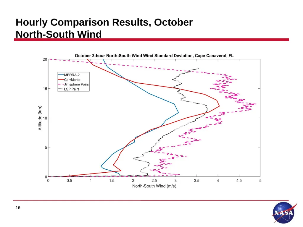
Hourly Comparison to Wind Pairs The hourly wind comparison at Cape Canaveral, FL consisted of:
3-hr MERRA-2 pairs
Jimsphere balloon 3-hour seasonal pairs
NASA Launch Service Provider (LSP) 3-hr pairs, composed of 50 MHz Doppler Radar Wind Profiler and 915 MHz Profiler
Earth-GRAM hourly wind dispersions
CorrMonte is function in Earth-GRAM that can evaluate multiple profiles separated by a fixed time increment
Earth-GRAM provides a monthly dispersion with Monte Carlo runs
CorrMonte provides an hourly dispersion with Monte Carlo runs
CorrMonte produces several profiles that are cross-correlated
CorrMonte is useful for providing less conservatism in certain spacecraft design and operational situations. 12<br>
13
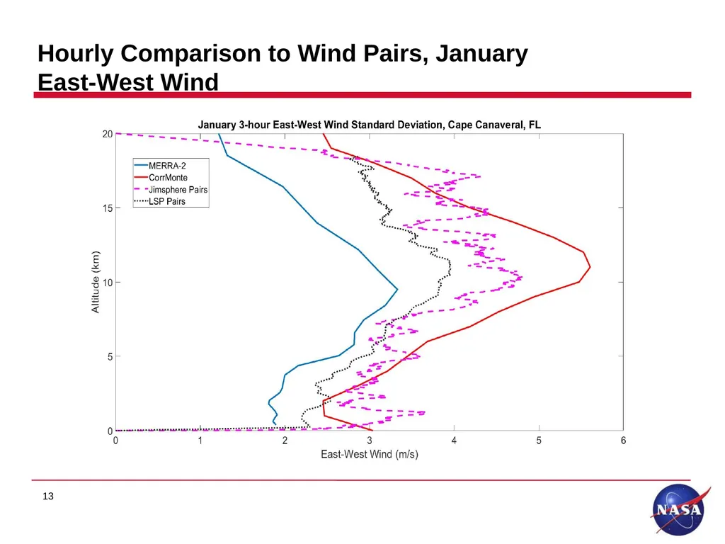
Hourly Comparison to Wind Pairs, January East-West Wind 13<br>
14
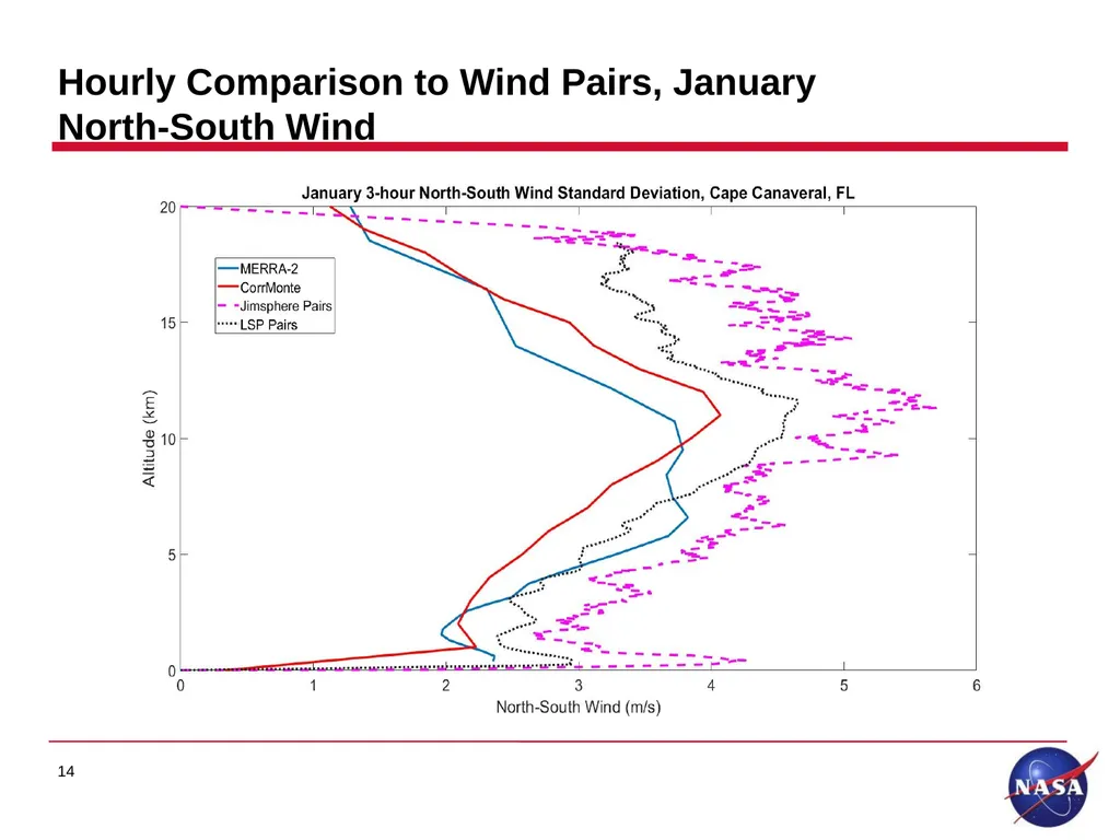
Hourly Comparison to Wind Pairs, January North-South Wind 14<br>
15
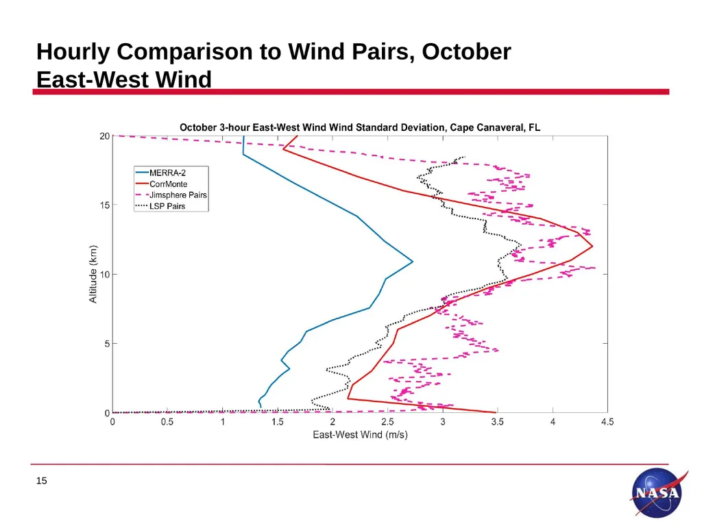
Hourly Comparison to Wind Pairs, October East-West Wind 15<br>
16
Hourly Comparison Results, October North-South Wind 16<br>
17
MERRA-2 Implementation, Background Developed by Goddard Modeling and Assimilation Office (GMAO)
Horizontal Resolution: 0.625°x0.5° longitude-by-latitude grid (NCEP reanalysis I, 2.5°x2.5° currently used in Earth-GRAM)
Vertical resolution: 72 model layers or interpolated to 42 pressure levels to 0.1 hPa (NCEP reanalysis I, 10hPa)
Input Observations:
Surface: land, ship and buoy observations
Upper Air: balloon, radar, wind profiler, satellite derived winds, and satellite retrieved measurements 17<br>
18
MERRA-2 Implementation Current plans to implement Earth-GRAM as a data source option.
Positive cases for implementing MERRA-2 into Earth-GRAM:
Improved horizontal resolution compared to NCEP Reanalysis I
Improved altitudinal extent of data compared to NCEP Reanalysis I
Showed good comparison to current Earth-GRAM data sources
Have developed global statistics on 42 pressure levels of east-west wind (U), north-south wind (V), total wind speed, and U-V correlation.
Calculated statistics compared well to Earth-GRAM data sources
Plans to develop global statistics for thermodynamic variables 18<br>
19
Boundary Layer Improvement Study Earth-GRAM uses a boundary layer model to approximate vertical wind standard deviation.
Vertical wind standard deviation dependent on: surface roughness (based on 1 degree surface code map), friction velocity, surface elevation, solar elevation angle and time of day, and Monin-Obukhov length.
Earth-GRAM currently does not account for boundary layer effects on horizontal winds.
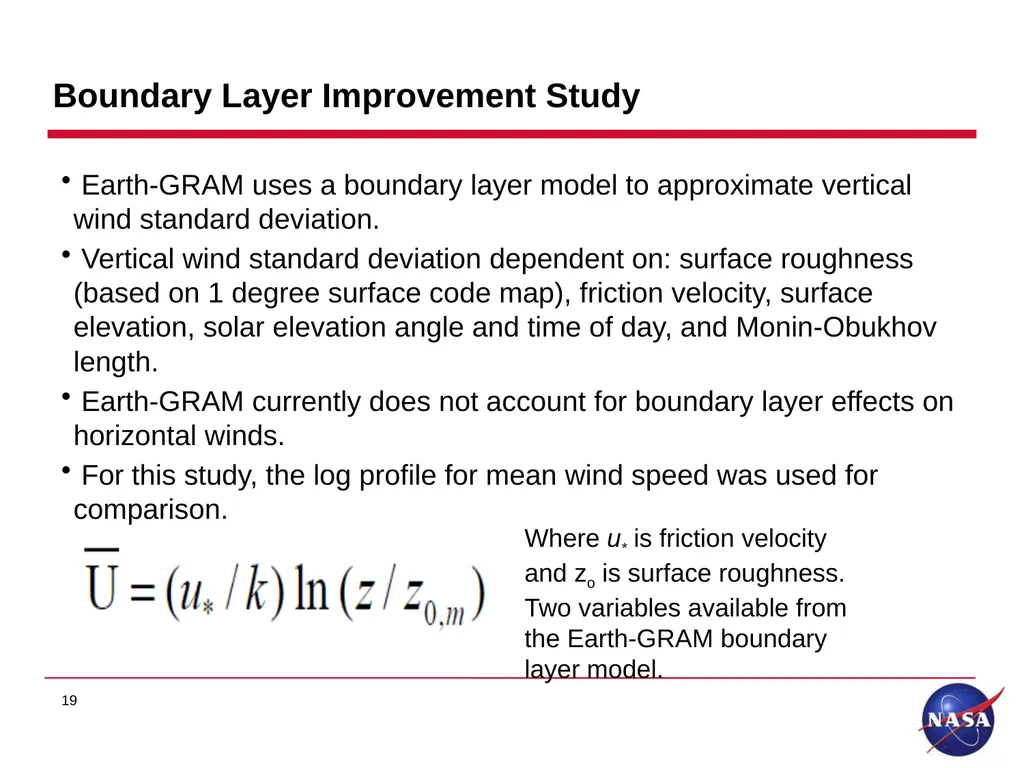
For this study, the log profile for mean wind speed was used for comparison. 19 Where u* is friction velocity
and zo is surface roughness.
Two variables available from
the Earth-GRAM boundary
layer model.<br>
20
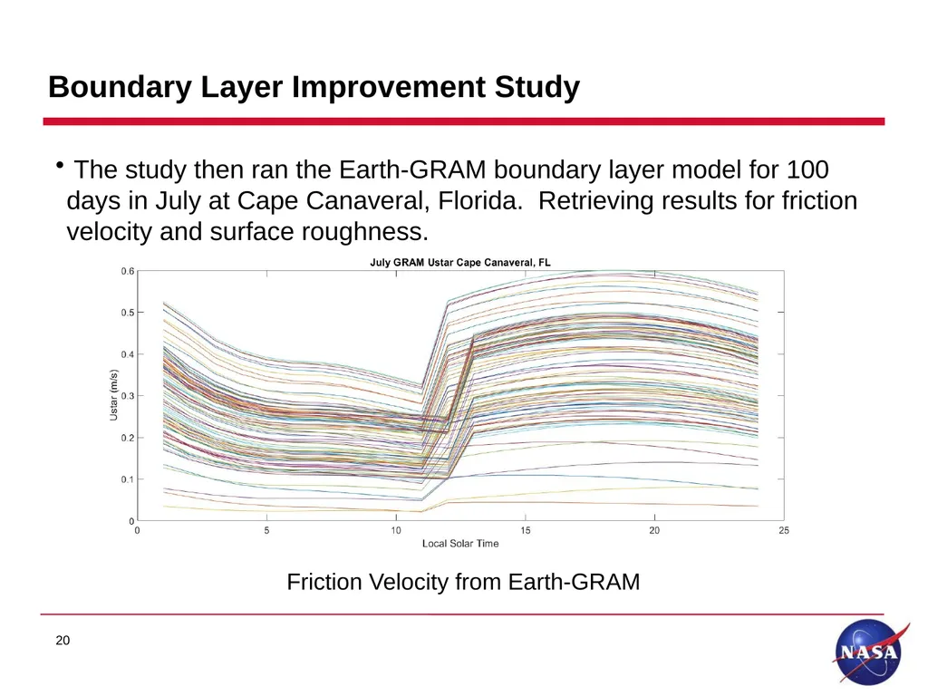
Boundary Layer Improvement Study 20 The study then ran the Earth-GRAM boundary layer model for 100 days in July at Cape Canaveral, Florida. Retrieving results for friction velocity and surface roughness. Friction Velocity from Earth-GRAM<br>
21
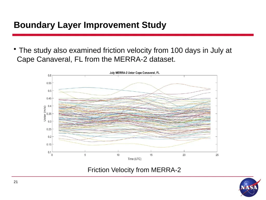
Boundary Layer Improvement Study The study also examined friction velocity from 100 days in July at Cape Canaveral, FL from the MERRA-2 dataset. 21 Friction Velocity from MERRA-2<br>
22
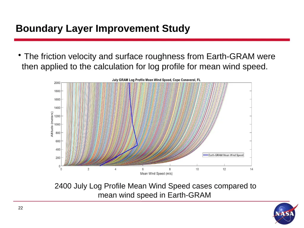
Boundary Layer Improvement Study The friction velocity and surface roughness from Earth-GRAM were then applied to the calculation for log profile for mean wind speed. 22 2400 July Log Profile Mean Wind Speed cases compared to
mean wind speed in Earth-GRAM<br>
23
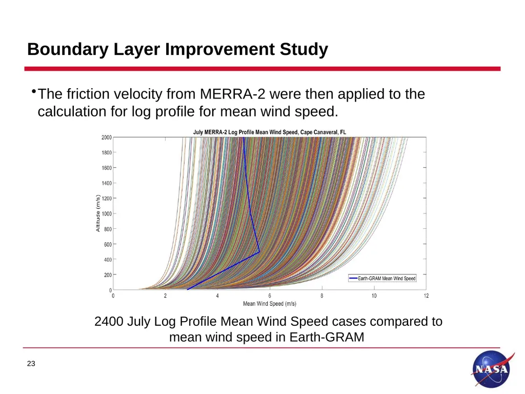
Boundary Layer Improvement Study The friction velocity from MERRA-2 were then applied to the calculation for log profile for mean wind speed. 23 2400 July Log Profile Mean Wind Speed cases compared to
mean wind speed in Earth-GRAM<br>
24
Summary CorrMonte shows favorable comparisons to wind pairs databases.
Earth-GRAM does not adequately account for boundary layer effects on horizontal winds
The Log Profile for Mean Wind Speed better characterizes boundary layer winds and varying stability cases.
Plans to continue to examine boundary layer improvements with Log Profile
Plans to continue implement MERRA-2 into Earth-GRAM
Plans to complete implementation in 2021
The GRAM team plans to continue to modernize the software, implement quality data sources, and improve areas of limitation. 24<br>