Geospatial Technology Evolution and Future Trends GIS for Spatial Planning Training for Ministry of Transport Mozambique Maputo, Mozambique 2-13 July 2018 Geoinformation and Sectoral Statistics Section Geospatial Technology Evolution Static
"Geospatial Technology Evolution and Future Trends" is the property of its rightful owner. Permission is granted to
download and print the materials on this website for personal, non-commercial use only, and to display it
on your personal computer provided you do not modify the materials and that you retain all copyright
notices contained in the materials. By downloading content from our website, you accept the terms of this
agreement.
Presentation Transcript
01
Geospatial Technology Evolution and Future Trends GIS for Spatial Planning
Training for Ministry of Transport
Mozambique
Maputo, Mozambique
2-13 July 2018 Geoinformation and Sectoral Statistics Section<br>
02
Geospatial Technology Evolution
Static and interactive maps and atlases
Web mapping and distributed processing
Google maps, Google Earth
Current and Future Trends
User generated content / Volunteer Geographic Information
Cloud computing Content<br>
03
3 GIS technology has evolved during last few decades
GIS technology is growing at faster rate both in hardware and software development
In recent years, traditional paper atlases have been replaced by electronic versions
Static and interactive atlases
Interactive atlases are now common: allowing users to manipulate the data sets
GIS servers are already providing the software architecture to enable multi-user access, serving maps and data on the Web
Distributed GIS, distributed processing
Web maps, web services, Geospatial Technology Evolution<br>
04
4 Web maps such as Google maps, and Google Earth
Google maps, and Google Earth in Tablets, Smart Phones
Getting driving directions, selecting destination for family vacation, navigate through the city, etc.
Mobile, wireless and location aware devices are currently used for maps and location based services (LBS)
A Location-Based Service (LBS) is an information service, accessible with mobile devices through the mobile network and utilizing the ability to make use of the geographical position of the mobile device Geospatial Technology Evolution<br>
05
Advances of mobile devices such as smart phones and wireless communications technologies facilitated spread of LBS
Services to identify a location of facilities and businesses (e.g. hospital, restaurants, fuel stations, etc.)
personal navigator, travel directions
traffic information service, weather services
proximity service (nearest ATM machine, nearest restaurant, etc.)
Technologies behind LBS is positioning, with the most widely recognized system being GPS
Wireless communications technologies, including wi-fi (Wireless Fidelity) and cellular network also facilitate its spread Geospatial Technology Evolution<br>
06
6 Cloud computing is a computing paradigm for enabling on-demand network access to a pool of computing resources (e.g. networks, servers, storage, applications, and services)
Presents the idea of distributed computing: Moving applications, services, and data from local storage to a dispersed set of servers and datacenters
Cloud based GIS/Geo Cloud: adopts cloud computing technology to provide GIS capabilities on the cloud
User can use a provider’s infrastructure and GIS capabilities
It lets someone else install, host, and manage it on remote servers Geospatial Technology Evolution<br>
07
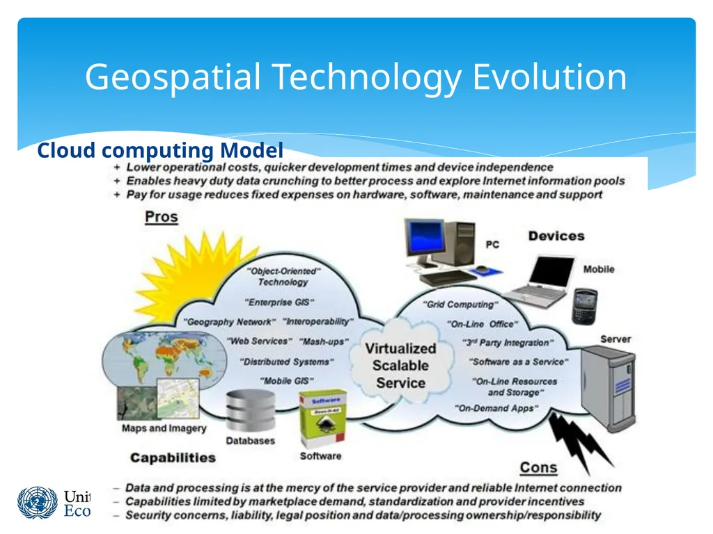
7 Cloud computing Model Geospatial Technology Evolution<br>
08
8 ArcGIS.com, makes maps and applications available online for everyone.
It allows the user to browse ArcGIS online content published by ESRI and the user community
Can upload own content and share it with the user community
Users can create their own story maps online to tell story on any theme Geospatial Technology Evolution<br>
09
9 Current and Future Trends of GIS Google Earth is a good example of cloud-like computing. It seamlessly brings together imagery from numerous datacenters
ESRI ArcGIS.com and ArcGIS Online provide cloud-based software and services, user storage, and access to GIS tools and imagery to the GIS community
ArcGIS Online: enables users to use diverse web resources, including those offered by the ESRI ArcGIS Online cloud and those contributed by the user community<br>
10
Crowd sourcing is the act of outsourcing tasks, traditionally performed by an employee or contractor, to an undefined, large group of people or community (a "crowd"), through an open call
Maps can be worked on by individuals, and communities crowd sourced, enabling them to place information on base maps
User Generated Content (UGC) is content that has been contributed by Web users (e.g. Wikipedia, YouTube, Facebook, etc. )
Volunteered geographic information (VGI) is UGC of a geospatial nature
VGI is digital spatial data that is created voluntarily by citizens rather than by formal data producers
Wikimapia and OpenStretMap use Web-based “crowd-sourcing” technologies, which outsource tasks to the crowd to collect data
WikiMapia: is an online editable map, where users contribute geographic information describing the place on a map 10 Current and Future Trends of GIS<br>
11
11 Open Geospatial Web Services
Geospatial Web services are, and will continue to be, the heart of Web GIS.
A main basis of cloud-based GIS
GIS professionals can serve their authoritative data and knowledge as Web services Current and Future Trends of GIS<br>
12
12 Towards Ubiquitous GIS
LBS will continue to develop with the increased integration of GPS functionality with increasingly powerful mobile devices (cell phones, PDAs, laptops, etc.)
Web GIS is becoming ubiquitous - it is available on our desktops, laptops, cell phones, GPS navigators, and other mobile devices anywhere, anytime
The omnipresence of GIS/ubiquitous will make mobile GIS available to anyone, at anytime, and anywhere. Current and Future Trends of GIS<br>