
Remote Sensing and GIS Application Lecturer Ruba
TF
Published · 19 slides · 0 views

1 / 1
Description
Remote Sensing and GIS Application Lecturer Ruba Yousif Hussain Third Year 1 Basic Principal of Photogrammetry Photogrammetry Photogrammetry is the science of making measurements from aerial photographs. Vertical photographs Photographs
Related Topics
Share
Embed code
Download this presentation From Below
"Remote Sensing and GIS Application Lecturer Ruba" is the property of its rightful owner. Permission is granted to download and print the materials on this website for personal, non-commercial use only, and to display it on your personal computer provided you do not modify the materials and that you retain all copyright notices contained in the materials. By downloading content from our website, you accept the terms of this agreement.
Presentation Transcript
01
Remote Sensing
and GIS Application Lecturer
Ruba Yousif Hussain
Third Year 1<br>
Ruba Yousif Hussain
Third Year 1<br>
02
Basic Principal of Photogrammetry Photogrammetry
Photogrammetry is the science of making measurements from aerial photographs.
Vertical photographs
Photographs taken from an aircraft with the optical axis of the camera vertical or as nearly vertical as possible .
Scale
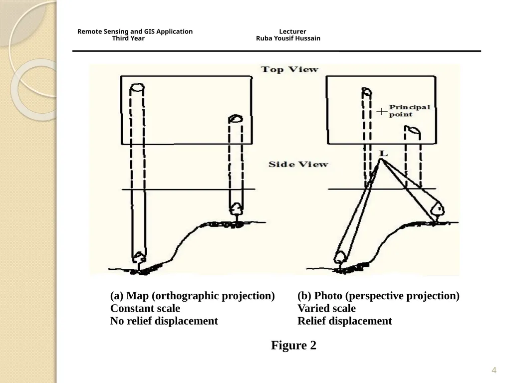
On a map, scale is everywhere uniform because a map is an orthographic projection. An aerial photograph, is a perspective projection and its scale varies with variations in terrain elevation. 2 Remote Sensing and GIS Application Lecturer Third Year Ruba Yousif Hussain<br>
Photogrammetry is the science of making measurements from aerial photographs.
Vertical photographs
Photographs taken from an aircraft with the optical axis of the camera vertical or as nearly vertical as possible .
Scale
On a map, scale is everywhere uniform because a map is an orthographic projection. An aerial photograph, is a perspective projection and its scale varies with variations in terrain elevation. 2 Remote Sensing and GIS Application Lecturer Third Year Ruba Yousif Hussain<br>
03
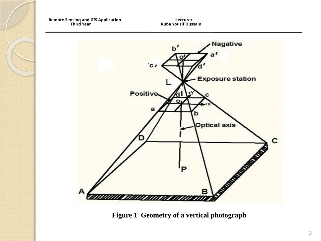
3 Figure 1 Geometry of a vertical photograph Remote Sensing and GIS Application Lecturer
Third Year Ruba Yousif Hussain<br>
04
4 Remote Sensing and GIS Application Lecturer
Third Year Ruba Yousif Hussain<br>
05
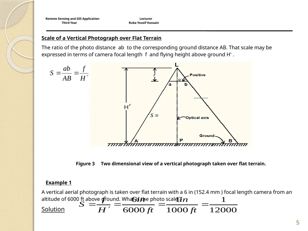
Scale of a Vertical Photograph over Flat Terrain
The ratio of the photo distance ab to the corresponding ground distance AB. That scale may be expressed in terms of camera focal length f and flying height above ground H' .
Figure 3 Two dimensional view of a vertical photograph taken over flat terrain.
Example 1
A vertical aerial photograph is taken over flat terrain with a 6 in (152.4 mm ) focal length camera from an altitude of 6000 ft above ground. What is the photo scale ?
Solution 5 Remote Sensing and GIS Application Lecturer Third Year Ruba Yousif Hussain<br>
The ratio of the photo distance ab to the corresponding ground distance AB. That scale may be expressed in terms of camera focal length f and flying height above ground H' .
Figure 3 Two dimensional view of a vertical photograph taken over flat terrain.
Example 1
A vertical aerial photograph is taken over flat terrain with a 6 in (152.4 mm ) focal length camera from an altitude of 6000 ft above ground. What is the photo scale ?
Solution 5 Remote Sensing and GIS Application Lecturer Third Year Ruba Yousif Hussain<br>
06
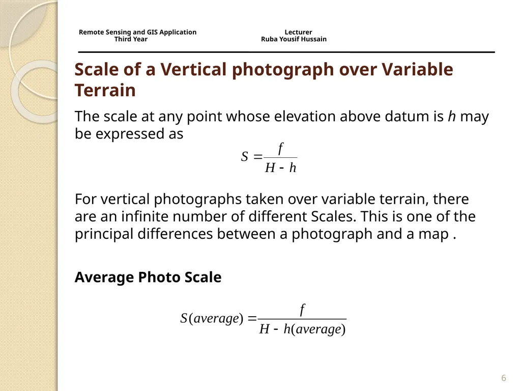
Scale of a Vertical photograph over Variable Terrain The scale at any point whose elevation above datum is h may be expressed as
For vertical photographs taken over variable terrain, there are an infinite number of different Scales. This is one of the principal differences between a photograph and a map .
Average Photo Scale 6 Remote Sensing and GIS Application Lecturer Third Year Ruba Yousif Hussain<br>
For vertical photographs taken over variable terrain, there are an infinite number of different Scales. This is one of the principal differences between a photograph and a map .
Average Photo Scale 6 Remote Sensing and GIS Application Lecturer Third Year Ruba Yousif Hussain<br>
07
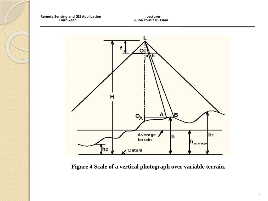
7 Figure 4 Scale of a vertical photograph over variable terrain. Remote Sensing and GIS Application Lecturer
Third Year Ruba Yousif Hussain<br>
08
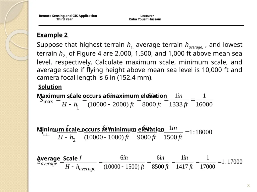
Example 2
Suppose that highest terrain h1, average terrain haverage, , and lowest terrain h2 , of Figure 4 are 2,000, 1,500, and 1,000 ft above mean sea level, respectively. Calculate maximum scale, minimum scale, and average scale if flying height above mean sea level is 10,000 ft and camera focal length is 6 in (152.4 mm).
Solution
Maximum scale occurs at maximum elevation
Minimum scale occurs at minimum elevation
Average Scale 8 Remote Sensing and GIS Application Lecturer Third Year Ruba Yousif Hussain<br>
Suppose that highest terrain h1, average terrain haverage, , and lowest terrain h2 , of Figure 4 are 2,000, 1,500, and 1,000 ft above mean sea level, respectively. Calculate maximum scale, minimum scale, and average scale if flying height above mean sea level is 10,000 ft and camera focal length is 6 in (152.4 mm).
Solution
Maximum scale occurs at maximum elevation
Minimum scale occurs at minimum elevation
Average Scale 8 Remote Sensing and GIS Application Lecturer Third Year Ruba Yousif Hussain<br>
09
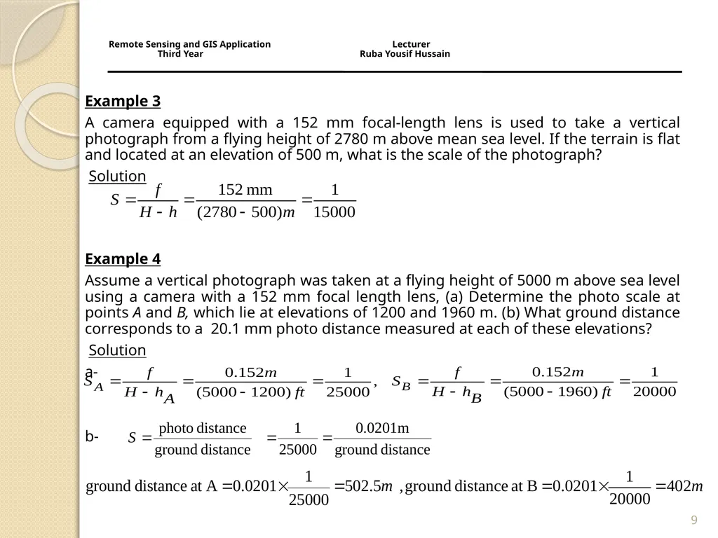
9 Example 3
A camera equipped with a 152 mm focal-length lens is used to take a vertical photograph from a flying height of 2780 m above mean sea level. If the terrain is flat and located at an elevation of 500 m, what is the scale of the photograph?
Solution
Example 4
Assume a vertical photograph was taken at a flying height of 5000 m above sea level using a camera with a 152 mm focal length lens, (a) Determine the photo scale at points A and B, which lie at elevations of 1200 and 1960 m. (b) What ground distance corresponds to a 20.1 mm photo distance measured at each of these elevations?
Solution
a-
b- Remote Sensing and GIS Application Lecturer Third Year Ruba Yousif Hussain<br>
A camera equipped with a 152 mm focal-length lens is used to take a vertical photograph from a flying height of 2780 m above mean sea level. If the terrain is flat and located at an elevation of 500 m, what is the scale of the photograph?
Solution
Example 4
Assume a vertical photograph was taken at a flying height of 5000 m above sea level using a camera with a 152 mm focal length lens, (a) Determine the photo scale at points A and B, which lie at elevations of 1200 and 1960 m. (b) What ground distance corresponds to a 20.1 mm photo distance measured at each of these elevations?
Solution
a-
b- Remote Sensing and GIS Application Lecturer Third Year Ruba Yousif Hussain<br>
10
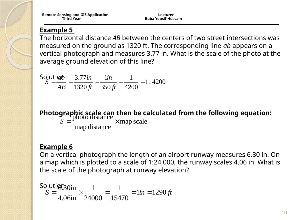
Example 5
The horizontal distance AB between the centers of two street intersections was measured on the ground as 1320 ft. The corresponding line ab appears on a vertical photograph and measures 3.77 in. What is the scale of the photo at the average ground elevation of this line?
Solution
Photographic scale can then be calculated from the following equation:
Example 6 On a vertical photograph the length of an airport runway measures 6.30 in. On a map which is plotted to a scale of 1:24,000, the runway scales 4.06 in. What is the scale of the photograph at runway elevation? Solution 10 Remote Sensing and GIS Application Lecturer Third Year Ruba Yousif Hussain<br>
Photographic scale can then be calculated from the following equation:
Example 6 On a vertical photograph the length of an airport runway measures 6.30 in. On a map which is plotted to a scale of 1:24,000, the runway scales 4.06 in. What is the scale of the photograph at runway elevation? Solution 10 Remote Sensing and GIS Application Lecturer Third Year Ruba Yousif Hussain<br>
11
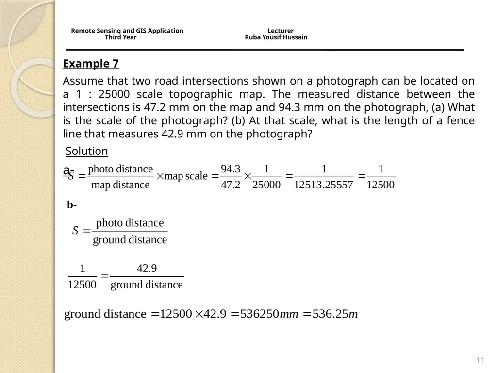
Example 7
Assume that two road intersections shown on a photograph can be located on a 1 : 25000 scale topographic map. The measured distance between the intersections is 47.2 mm on the map and 94.3 mm on the photograph, (a) What is the scale of the photograph? (b) At that scale, what is the length of a fence line that measures 42.9 mm on the photograph?
Solution
a- 11 b- Remote Sensing and GIS Application Lecturer Third Year Ruba Yousif Hussain<br>
Assume that two road intersections shown on a photograph can be located on a 1 : 25000 scale topographic map. The measured distance between the intersections is 47.2 mm on the map and 94.3 mm on the photograph, (a) What is the scale of the photograph? (b) At that scale, what is the length of a fence line that measures 42.9 mm on the photograph?
Solution
a- 11 b- Remote Sensing and GIS Application Lecturer Third Year Ruba Yousif Hussain<br>
12
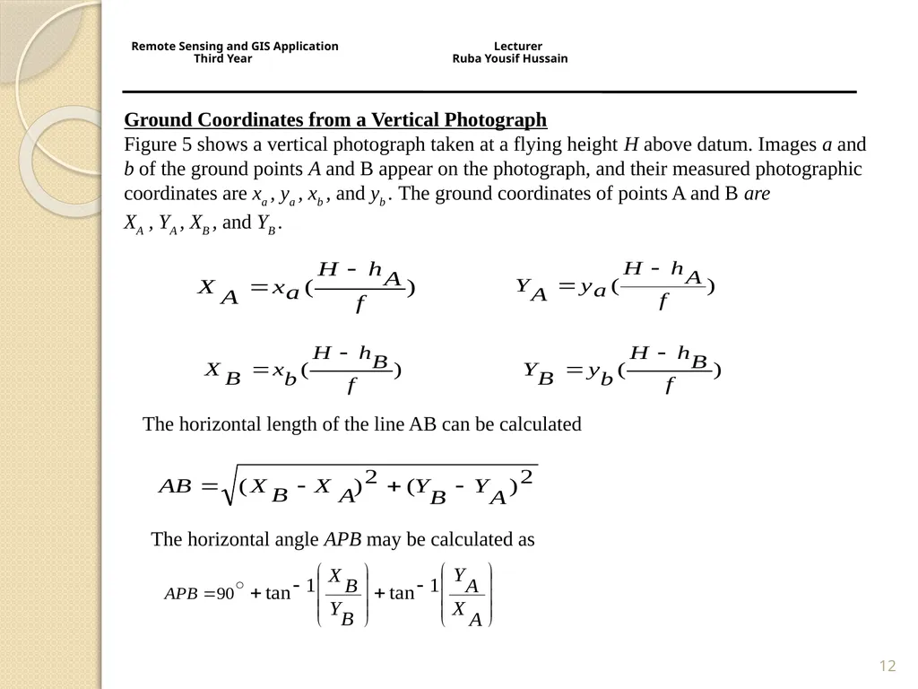
12 Remote Sensing and GIS Application Lecturer
Third Year Ruba Yousif Hussain<br>
13
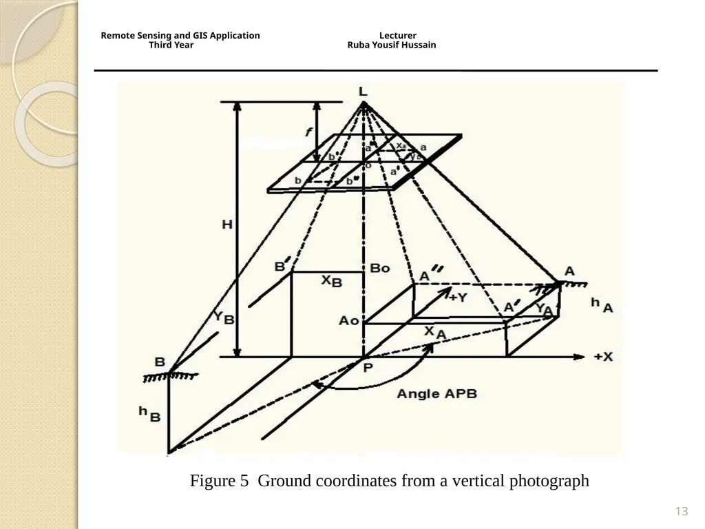
13 Figure 5 Ground coordinates from a vertical photograph Remote Sensing and GIS Application Lecturer
Third Year Ruba Yousif Hussain<br>
14
Example 8
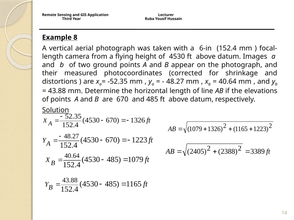
A vertical aerial photograph was taken with a 6-in (152.4 mm ) focal-length camera from a flying height of 4530 ft above datum. Images a and b of two ground points A and B appear on the photograph, and their measured photocoordinates (corrected for shrinkage and distortions ) are xa= -52.35 mm , ya = - 48.27 mm , xb = 40.64 mm , and yb = 43.88 mm. Determine the horizontal length of line AB if the elevations of points A and B are 670 and 485 ft above datum, respectively.
Solution 14 Remote Sensing and GIS Application Lecturer Third Year Ruba Yousif Hussain<br>
A vertical aerial photograph was taken with a 6-in (152.4 mm ) focal-length camera from a flying height of 4530 ft above datum. Images a and b of two ground points A and B appear on the photograph, and their measured photocoordinates (corrected for shrinkage and distortions ) are xa= -52.35 mm , ya = - 48.27 mm , xb = 40.64 mm , and yb = 43.88 mm. Determine the horizontal length of line AB if the elevations of points A and B are 670 and 485 ft above datum, respectively.
Solution 14 Remote Sensing and GIS Application Lecturer Third Year Ruba Yousif Hussain<br>
15
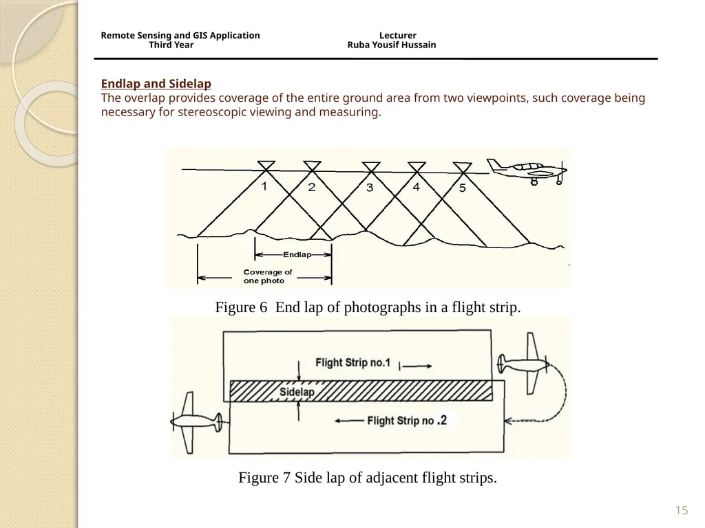
Endlap and Sidelap
The overlap provides coverage of the entire ground area from two viewpoints, such coverage being necessary for stereoscopic viewing and measuring. 15 Figure 6 End lap of photographs in a flight strip. Figure 7 Side lap of adjacent flight strips. Remote Sensing and GIS Application Lecturer
Third Year Ruba Yousif Hussain<br>
16
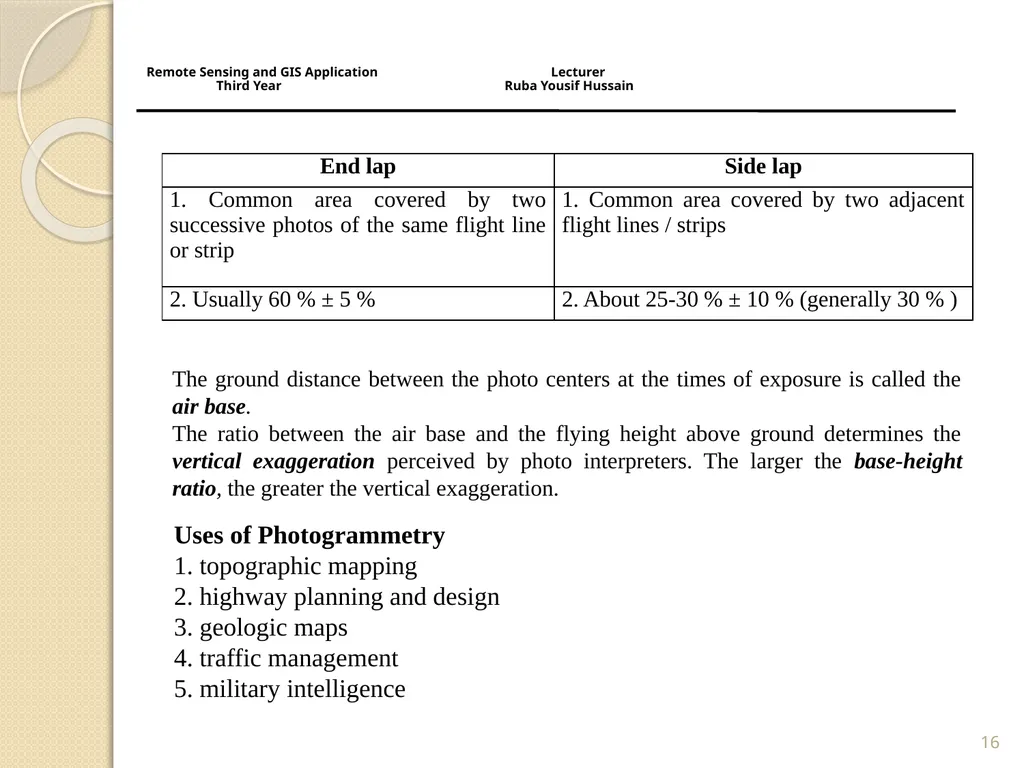
16 The ground distance between the photo centers at the times of exposure is called the air base.
The ratio between the air base and the flying height above ground determines the vertical exaggeration perceived by photo interpreters. The larger the base-height ratio, the greater the vertical exaggeration. Uses of Photogrammetry
1. topographic mapping
2. highway planning and design
3. geologic maps
4. traffic management
5. military intelligence Remote Sensing and GIS Application Lecturer Third Year Ruba Yousif Hussain<br>
The ratio between the air base and the flying height above ground determines the vertical exaggeration perceived by photo interpreters. The larger the base-height ratio, the greater the vertical exaggeration. Uses of Photogrammetry
1. topographic mapping
2. highway planning and design
3. geologic maps
4. traffic management
5. military intelligence Remote Sensing and GIS Application Lecturer Third Year Ruba Yousif Hussain<br>
17
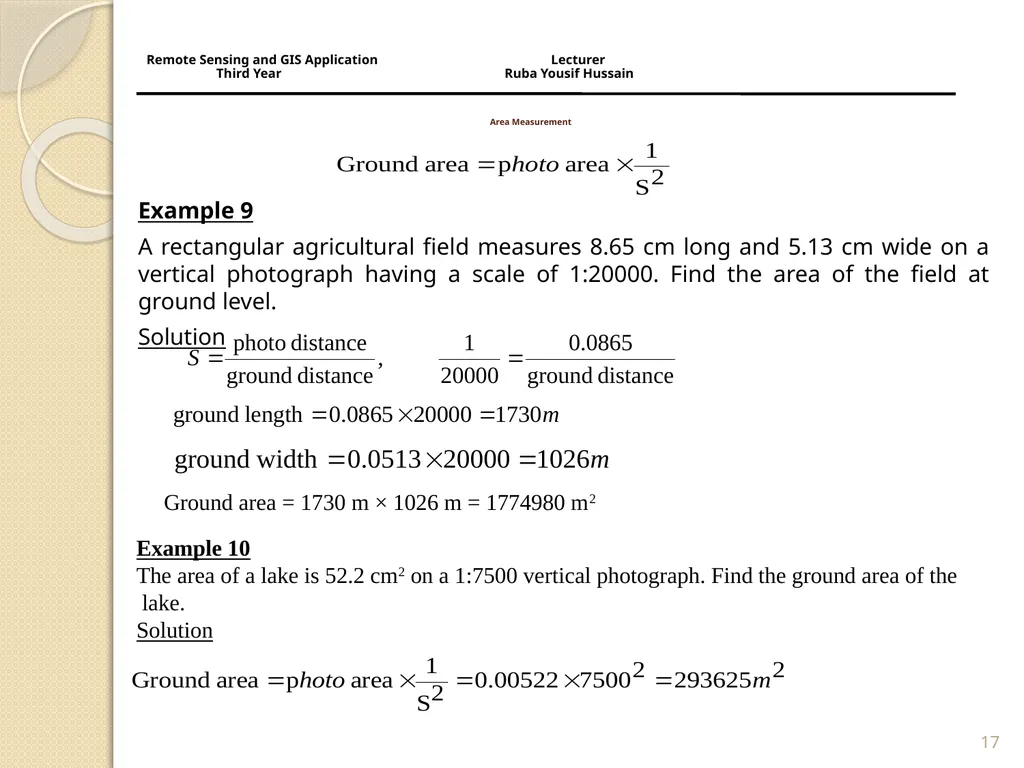
Area Measurement Example 9
A rectangular agricultural field measures 8.65 cm long and 5.13 cm wide on a vertical photograph having a scale of 1:20000. Find the area of the field at ground level.
Solution 17 Ground area = 1730 m × 1026 m = 1774980 m2 Example 10
The area of a lake is 52.2 cm2 on a 1:7500 vertical photograph. Find the ground area of the
lake.
Solution Remote Sensing and GIS Application Lecturer Third Year Ruba Yousif Hussain<br>
A rectangular agricultural field measures 8.65 cm long and 5.13 cm wide on a vertical photograph having a scale of 1:20000. Find the area of the field at ground level.
Solution 17 Ground area = 1730 m × 1026 m = 1774980 m2 Example 10
The area of a lake is 52.2 cm2 on a 1:7500 vertical photograph. Find the ground area of the
lake.
Solution Remote Sensing and GIS Application Lecturer Third Year Ruba Yousif Hussain<br>
18
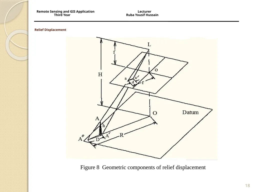
Relief Displacement 18 Figure 8 Geometric components of relief displacement Remote Sensing and GIS Application Lecturer
Third Year Ruba Yousif Hussain<br>
19
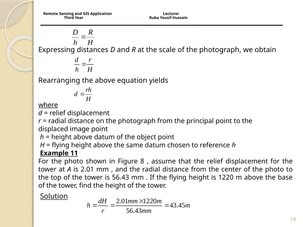
Expressing distances D and R at the scale of the photograph, we obtain
Rearranging the above equation yields
where
d = relief displacement
r = radial distance on the photograph from the principal point to the
displaced image point
h = height above datum of the object point
H = flying height above the same datum chosen to reference h
Example 11
For the photo shown in Figure 8 , assume that the relief displacement for the tower at A is 2.01 mm , and the radial distance from the center of the photo to the top of the tower is 56.43 mm . If the flying height is 1220 m above the base of the tower, find the height of the tower.
Solution 19 Remote Sensing and GIS Application Lecturer Third Year Ruba Yousif Hussain<br>
Rearranging the above equation yields
where
d = relief displacement
r = radial distance on the photograph from the principal point to the
displaced image point
h = height above datum of the object point
H = flying height above the same datum chosen to reference h
Example 11
For the photo shown in Figure 8 , assume that the relief displacement for the tower at A is 2.01 mm , and the radial distance from the center of the photo to the top of the tower is 56.43 mm . If the flying height is 1220 m above the base of the tower, find the height of the tower.
Solution 19 Remote Sensing and GIS Application Lecturer Third Year Ruba Yousif Hussain<br>