
SOCIAL SCIENCE POWERPOINT PRESENTATION India size




Description: SOCIAL SCIENCE POWERPOINT PRESENTATION India size and location Chapter 1 Location of India Location of India Southern Asia, bordering the Arabian Sea and the Bay of Bengal, between Myanmar and Pakistan. AreaTotal3,287,263 sq kmLand2,973,190
Related Topics
Download Presentation
"SOCIAL SCIENCE POWERPOINT PRESENTATION India size" is the property of its rightful owner. Permission is granted to download and print the materials on this website for personal, non-commercial use only, and to display it on your personal computer provided you do not modify the materials and that you retain all copyright notices contained in the materials. By downloading content from our website, you accept the terms of this agreement.
Presentation Transcript
slide1. SOCIAL SCIENCE POWERPOINT PRESENTATION<br>
slide2. India size and location Chapter 1<br>
slide3. Location of India Location of India Southern Asia, bordering the Arabian Sea and the Bay of Bengal, between Myanmar and Pakistan. AreaTotal3,287,263 sq kmLand2,973,190 sq kmWater314,400 sq km Comparative Slightly more than one-third the size of the US.<br>
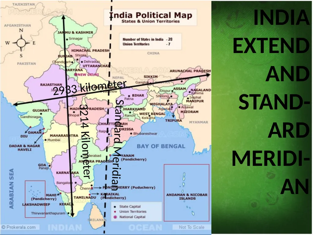
slide4. India is a vast country. The India main land extends between latitudes 8°4'nto 37°6'N and longitudes 68°7'E to 97°25'E. The tropic of cancer (23° 30'N) divides the country into almost two equal parts. To the southeast and southwest of the mainland, lie the Andaman and Nicobar islands and the Lakshadweep islands in Bay of Bengal and Arabian sea respectively.<br>
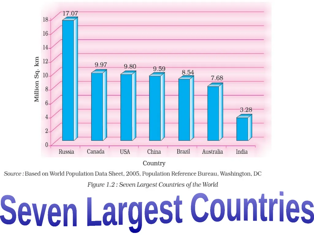
slide5. The land mass of India has an area of 3.28 million square km. India’s total area accounts for about 2.4 per cent of the total geographical area of the world.
India has a land boundary of about 15,200 km and the total length of the coast line of the mainland including Andaman and Nicobar an Lakshadweep is 7,516.6 km.<br>
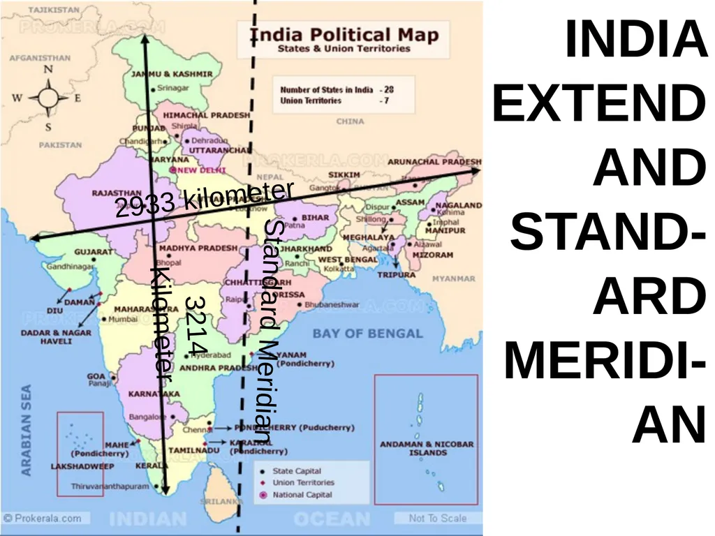
slide6. The latitudinal and longitudinal extent of the mainland is about 30°.
East-west extent appears to be smaller than the north-south extent.
From Gujarat to Arunachal Pradesh there is a time lag of two hours.
Hence, time along the standard meridian of India (82°30'e) passing through Gopiganj (Mirzapur in Uttar Pradesh) is taken as the standard time for the whole country.<br>
slide7. 2933 kilometer 3214 Kilometer Standard Meridian India extend and stand-ard meridi-an<br>
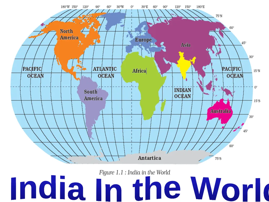
slide8. India In the World<br>
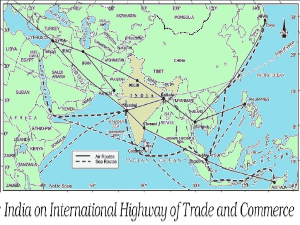
slide9. INDIA AND THE WORLD The Indian landmass has a central location between the east and the west Asia.
The trans Indian ocean routes which connect the countries of Europe in the west and the countries of east Asia provide a strategic central location to India.
India’s contacts with the World have continued through The ages but her relationships through the land routes are Much older than her maritime contacts.<br>
slide10. The various passes across the mountains in the north have provided passages to the ancient travelers, while the oceans restricted such interaction for a long time.
These routes have contributed in the exchange of ideas and commodities since ancient times.
The spices, muslin and other merchandise were taken from India to different countries.<br>
slide11. Seven Largest Countries<br>
slide12. 2933 kilometer 3214 Kilometer Standard Meridian India extend and stand-ard meridi-an<br>
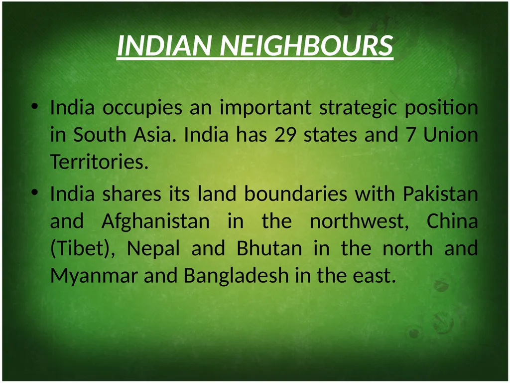
slide13. INDIAN NEIGHBOURS India occupies an important strategic position in South Asia. India has 29 states and 7 Union Territories.
India shares its land boundaries with Pakistan and Afghanistan in the northwest, China (Tibet), Nepal and Bhutan in the north and Myanmar and Bangladesh in the east.<br>
slide14. Our southern neighbours across the sea consist of the two island countries, namely Sri Lanka and Maldives. Sri Lanka is separated from India by a narrow channel of sea formed by the Palk Strait and the Gulf of Mannar while Maldives Islands are situated to the south of the Lakshadweep Islands.<br>
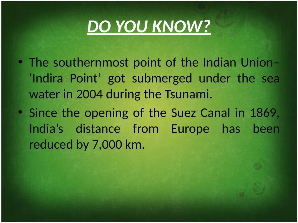
slide15. DO YOU KNOW? The southernmost point of the Indian Union– ‘Indira Point’ got submerged under the sea water in 2004 during the Tsunami.
Since the opening of the Suez Canal in 1869, India’s distance from Europe has been reduced by 7,000 km.<br>
slide16. Before 1947, there were two types of states in India – the provinces and the Princely states. Provinces were ruled directly by British officials who were appointed by the Viceroy. Princely states were ruled by local, hereditary rulers, who acknowledged sovereignty in return for local autonomy.<br>
slide18. Thank you By-SK RAI<br>
slide2. India size and location Chapter 1<br>
slide3. Location of India Location of India Southern Asia, bordering the Arabian Sea and the Bay of Bengal, between Myanmar and Pakistan. AreaTotal3,287,263 sq kmLand2,973,190 sq kmWater314,400 sq km Comparative Slightly more than one-third the size of the US.<br>
slide4. India is a vast country. The India main land extends between latitudes 8°4'nto 37°6'N and longitudes 68°7'E to 97°25'E. The tropic of cancer (23° 30'N) divides the country into almost two equal parts. To the southeast and southwest of the mainland, lie the Andaman and Nicobar islands and the Lakshadweep islands in Bay of Bengal and Arabian sea respectively.<br>
slide5. The land mass of India has an area of 3.28 million square km. India’s total area accounts for about 2.4 per cent of the total geographical area of the world.
India has a land boundary of about 15,200 km and the total length of the coast line of the mainland including Andaman and Nicobar an Lakshadweep is 7,516.6 km.<br>
slide6. The latitudinal and longitudinal extent of the mainland is about 30°.
East-west extent appears to be smaller than the north-south extent.
From Gujarat to Arunachal Pradesh there is a time lag of two hours.
Hence, time along the standard meridian of India (82°30'e) passing through Gopiganj (Mirzapur in Uttar Pradesh) is taken as the standard time for the whole country.<br>
slide7. 2933 kilometer 3214 Kilometer Standard Meridian India extend and stand-ard meridi-an<br>
slide8. India In the World<br>
slide9. INDIA AND THE WORLD The Indian landmass has a central location between the east and the west Asia.
The trans Indian ocean routes which connect the countries of Europe in the west and the countries of east Asia provide a strategic central location to India.
India’s contacts with the World have continued through The ages but her relationships through the land routes are Much older than her maritime contacts.<br>
slide10. The various passes across the mountains in the north have provided passages to the ancient travelers, while the oceans restricted such interaction for a long time.
These routes have contributed in the exchange of ideas and commodities since ancient times.
The spices, muslin and other merchandise were taken from India to different countries.<br>
slide11. Seven Largest Countries<br>
slide12. 2933 kilometer 3214 Kilometer Standard Meridian India extend and stand-ard meridi-an<br>
slide13. INDIAN NEIGHBOURS India occupies an important strategic position in South Asia. India has 29 states and 7 Union Territories.
India shares its land boundaries with Pakistan and Afghanistan in the northwest, China (Tibet), Nepal and Bhutan in the north and Myanmar and Bangladesh in the east.<br>
slide14. Our southern neighbours across the sea consist of the two island countries, namely Sri Lanka and Maldives. Sri Lanka is separated from India by a narrow channel of sea formed by the Palk Strait and the Gulf of Mannar while Maldives Islands are situated to the south of the Lakshadweep Islands.<br>
slide15. DO YOU KNOW? The southernmost point of the Indian Union– ‘Indira Point’ got submerged under the sea water in 2004 during the Tsunami.
Since the opening of the Suez Canal in 1869, India’s distance from Europe has been reduced by 7,000 km.<br>
slide16. Before 1947, there were two types of states in India – the provinces and the Princely states. Provinces were ruled directly by British officials who were appointed by the Viceroy. Princely states were ruled by local, hereditary rulers, who acknowledged sovereignty in return for local autonomy.<br>
slide18. Thank you By-SK RAI<br>