
Soil and climatic conditions prevalent in rainfed
BR
Published · 94 slides · 0 views

1 / 1

Description
Soil and climatic conditions prevalent in rainfed areas Delivered by Mr. ANIL SWAMI Asst. Professor 1 Rainfed Agriculture Watershed Management Mr. ANIL SWAMI Objective:- Tell the soil and climatic conditions prevalent in rainfed areas.
Related Topics
Share
Embed code
Download this presentation From Below
"Soil and climatic conditions prevalent in rainfed" is the property of its rightful owner. Permission is granted to download and print the materials on this website for personal, non-commercial use only, and to display it on your personal computer provided you do not modify the materials and that you retain all copyright notices contained in the materials. By downloading content from our website, you accept the terms of this agreement.
Presentation Transcript
01
Soil and climatic conditions prevalent in rainfed areas Delivered by
Mr. ANIL SWAMI
Asst. Professor 1 Rainfed Agriculture & Watershed Management Mr. ANIL SWAMI<br>
Mr. ANIL SWAMI
Asst. Professor 1 Rainfed Agriculture & Watershed Management Mr. ANIL SWAMI<br>
02
Objective:-
Tell the soil and climatic conditions prevalent in rainfed areas.
Interpret various water harvesting techniques and their efficient utilization.
Apply contingent crop planning for aberrant weather conditions.
Examine the seasonal rainfall and different types of watershed and its components.
Select soil and water conservation techniques to avoid their losses. 2<br>
03
3 Soil
Soil is the uppermost part of the earth crust containing a mixture of minerals. It is a three-phase system containing solid, liquid and gaseous components existing in certain equilibrium.<br>
Soil is the uppermost part of the earth crust containing a mixture of minerals. It is a three-phase system containing solid, liquid and gaseous components existing in certain equilibrium.<br>
04
4 Ideal dry land soils
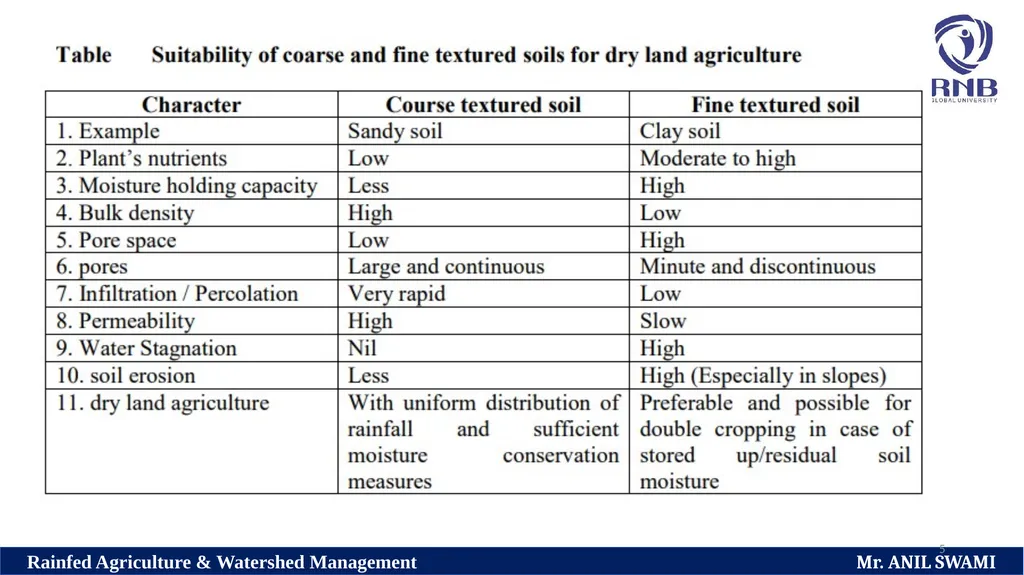
Soil texture has a profound influence on the productivity of soil.
In general depth, texture, structure, drainage conditions and soil moisture relationship are very important soil properties, which decide the crop growth.
Advantages and disadvantages of coarse and fine textured soils regarding crop cultivation are listed in Table<br>
05
5<br>
06
6 Dry land soils and their characteristics:
In India, dry land occurs in almost all the regions of the country and the major soil types in these dry regions are red soils (Alfisols), black soils (Inceptisols and Vertisols), Laterite soils (Ultisols) and desert soils (Aridisols).
The characteristics, features of the major soil groups and the prospects for raising crops in these soils under dry land conditions are described hereunder.<br>
07
7 Red soils (Alfisols) :
Red soil is an important soil group in India and especially in dry land.
These soils are moderately weathered and derived from granites, gneiss and other metamorphic rocks, either in-situ or from these decomposed rock materials washed down to lower level by rain.
They are generally red or reddish brown or yellowish brown in colour due to the coating of ferric oxides on soil particles.<br>
08
8 Morphological types are red loams and red earth with loose topsoil.
Main features of red soils are light texture, friable structure, absence of lime concretions and free calcium carbonates and contents of soluble salts.
These soils are slightly acidic to slightly alkaline nature, medium in cation exchange capacities and near base saturated.
Dominant clay mineral is k
Kaolinite with an admixture of Illite.
Red soils are well drained with a moderate permeability.<br>
09
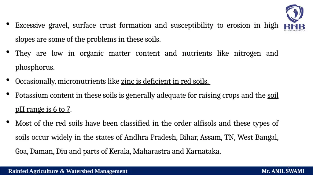
9 Excessive gravel, surface crust formation and susceptibility to erosion in high slopes are some of the problems in these soils.
They are low in organic matter content and nutrients like nitrogen and phosphorus.
Occasionally, micronutrients like zinc is deficient in red soils.
Potassium content in these soils is generally adequate for raising crops and the soil pH range is 6 to 7.
Most of the red soils have been classified in the order alfisols and these types of soils occur widely in the states of Andhra Pradesh, Bihar, Assam, TN, West Bangal, Goa, Daman, Diu and parts of Kerala, Maharastra and Karnataka.<br>
10
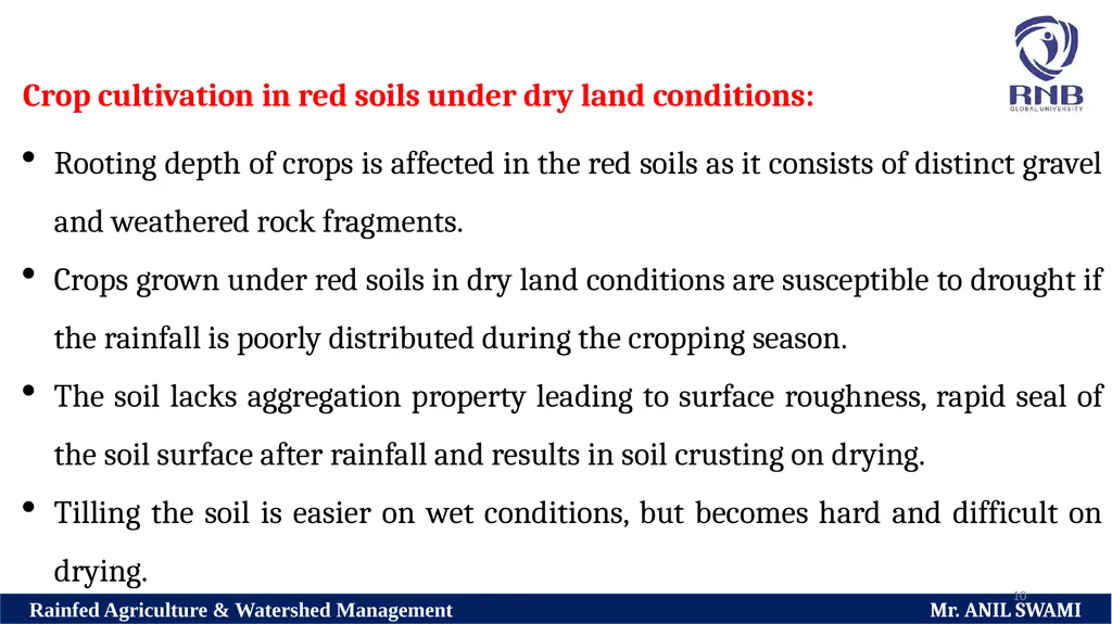
10 Crop cultivation in red soils under dry land conditions:
Rooting depth of crops is affected in the red soils as it consists of distinct gravel and weathered rock fragments.
Crops grown under red soils in dry land conditions are susceptible to drought if the rainfall is poorly distributed during the cropping season.
The soil lacks aggregation property leading to surface roughness, rapid seal of the soil surface after rainfall and results in soil crusting on drying.
Tilling the soil is easier on wet conditions, but becomes hard and difficult on drying.<br>
11
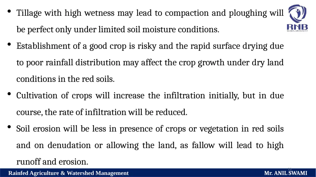
11 Tillage with high wetness may lead to compaction and ploughing will be perfect only under limited soil moisture conditions.
Establishment of a good crop is risky and the rapid surface drying due to poor rainfall distribution may affect the crop growth under dry land conditions in the red soils.
Cultivation of crops will increase the infiltration initially, but in due course, the rate of infiltration will be reduced.
Soil erosion will be less in presence of crops or vegetation in red soils and on denudation or allowing the land, as fallow will lead to high runoff and erosion.<br>
12
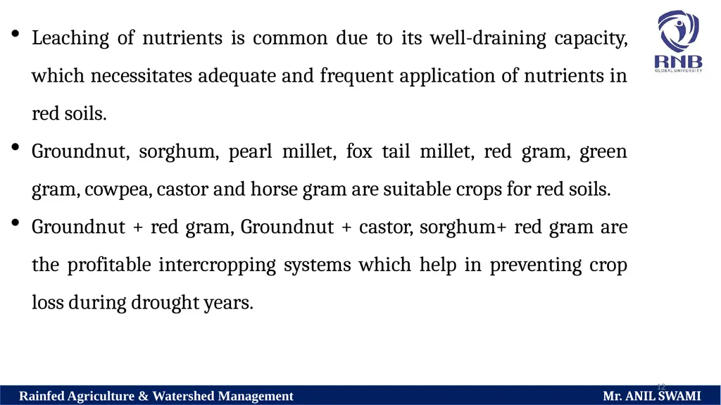
12 Leaching of nutrients is common due to its well-draining capacity, which necessitates adequate and frequent application of nutrients in red soils.
Groundnut, sorghum, pearl millet, fox tail millet, red gram, green gram, cowpea, castor and horse gram are suitable crops for red soils.
Groundnut + red gram, Groundnut + castor, sorghum+ red gram are the profitable intercropping systems which help in preventing crop loss during drought years.<br>
Groundnut, sorghum, pearl millet, fox tail millet, red gram, green gram, cowpea, castor and horse gram are suitable crops for red soils.
Groundnut + red gram, Groundnut + castor, sorghum+ red gram are the profitable intercropping systems which help in preventing crop loss during drought years.<br>
13
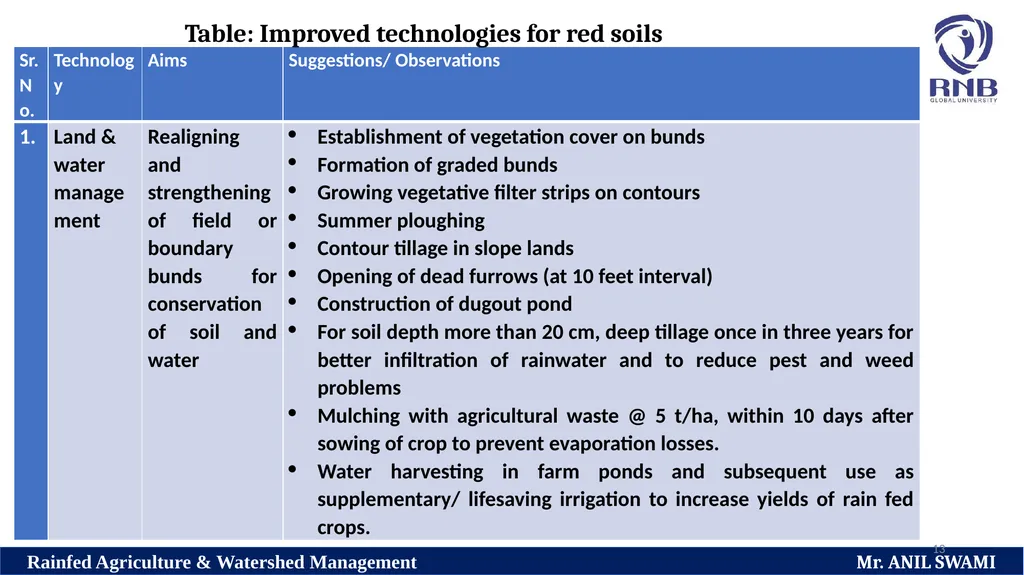
13 Table: Improved technologies for red soils<br>
14
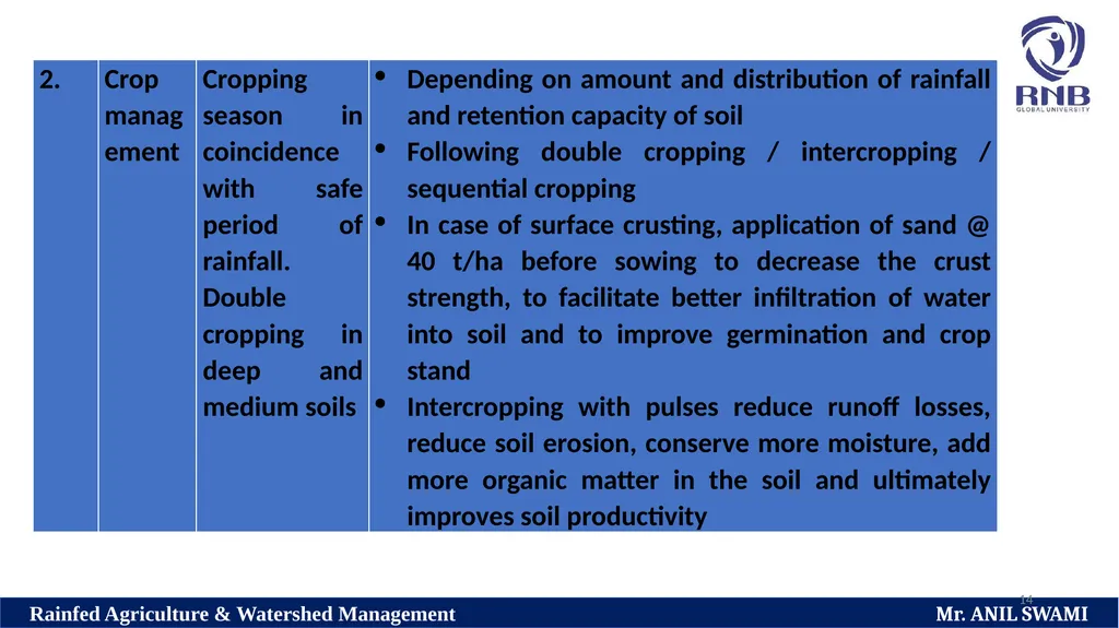
14<br>
15
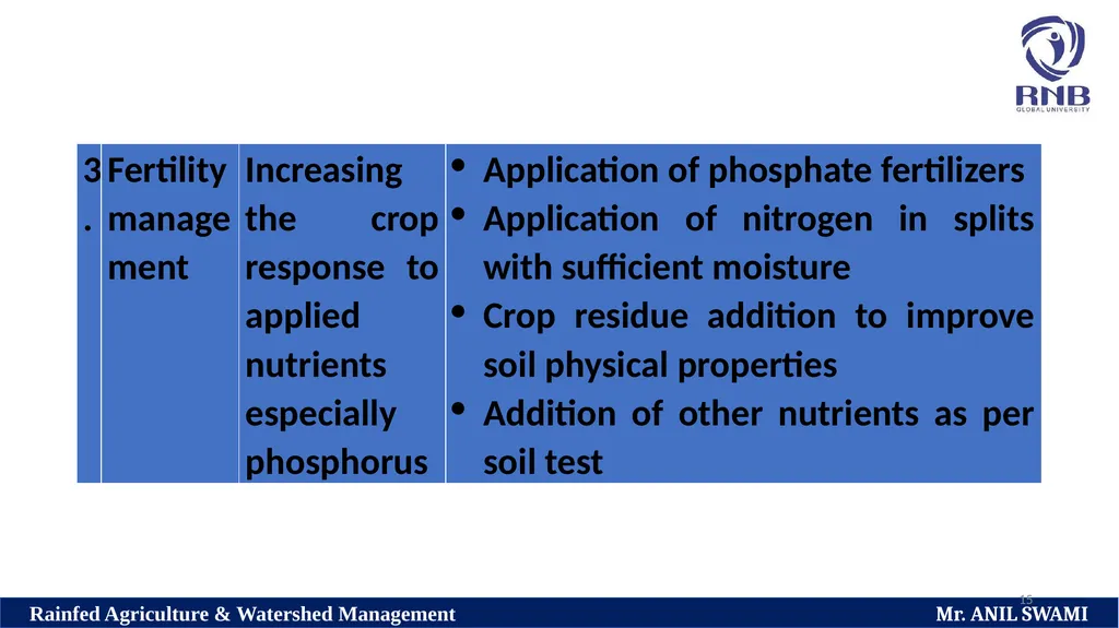
15<br>
16
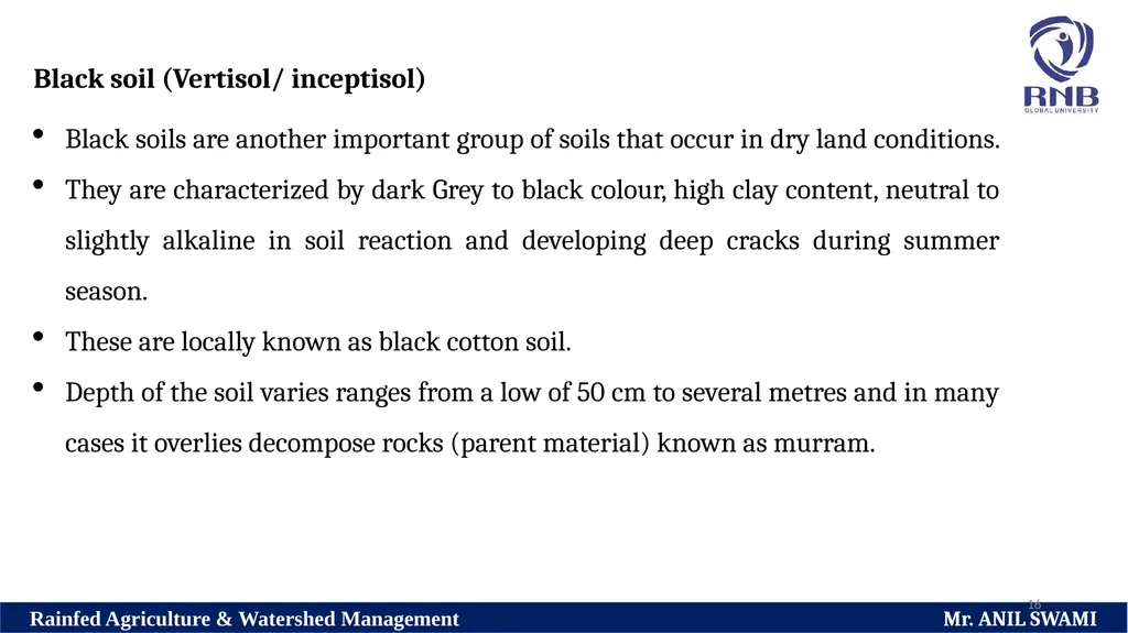
16 Black soil (Vertisol/ inceptisol)
Black soils are another important group of soils that occur in dry land conditions.
They are characterized by dark Grey to black colour, high clay content, neutral to slightly alkaline in soil reaction and developing deep cracks during summer season.
These are locally known as black cotton soil.
Depth of the soil varies ranges from a low of 50 cm to several metres and in many cases it overlies decompose rocks (parent material) known as murram.<br>
17
17 Black soil are formed from Deccan basalt trap rocks either in-situ or on the transported parent material.
In the formation of black soils, presence of a high proportion of alkaline earth in the weathering complex is of great importance.
These soils have impeded drainage and low permeability.
It occurs in areas under monsoon climate, mostly in semi-arid and sub humid type.<br>
In the formation of black soils, presence of a high proportion of alkaline earth in the weathering complex is of great importance.
These soils have impeded drainage and low permeability.
It occurs in areas under monsoon climate, mostly in semi-arid and sub humid type.<br>
18
18 High clay content and montmorillonite type of clay mineral impart high swelling and shrinkage properties of these soils.
Black soils are low in organic matter content, available nitrogen and phosphorus and sometimes zinc, but reach in base nutrients like calcium, magnesium and potassium.
Soil pH is in the range of 7.5 to 8.5. Soil is highly clayey and the clay content varies from 35 to 60% and sometimes up to 80%.<br>
19
19 These soils are characterized by high swelling and shrinkage, plasticity and stickiness.
Black soils are generally calcareous neutral to slightly alkaline in reaction, high base status and high cation exchange capacity.
They possess high soil moisture holding capacity.<br>
Black soils are generally calcareous neutral to slightly alkaline in reaction, high base status and high cation exchange capacity.
They possess high soil moisture holding capacity.<br>
20
20 Runoff is severe in black soil and it is prone to erosion and the soil loss is estimated to be in the range of 6 to 8 t/ha per year.
Shallow black soils on slopes have been classified in the order of Entisolsl and Inceptisols, while the deep medium black soils in the order of Vertisols.
Black soil occur extensively in the states of Maharashtra, Madhya Pradesh and parts of Andhra Pradesh, Gujarat and Tamilnadu.<br>
Shallow black soils on slopes have been classified in the order of Entisolsl and Inceptisols, while the deep medium black soils in the order of Vertisols.
Black soil occur extensively in the states of Maharashtra, Madhya Pradesh and parts of Andhra Pradesh, Gujarat and Tamilnadu.<br>
21
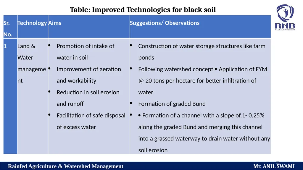
21 Table: Improved Technologies for black soil<br>
22
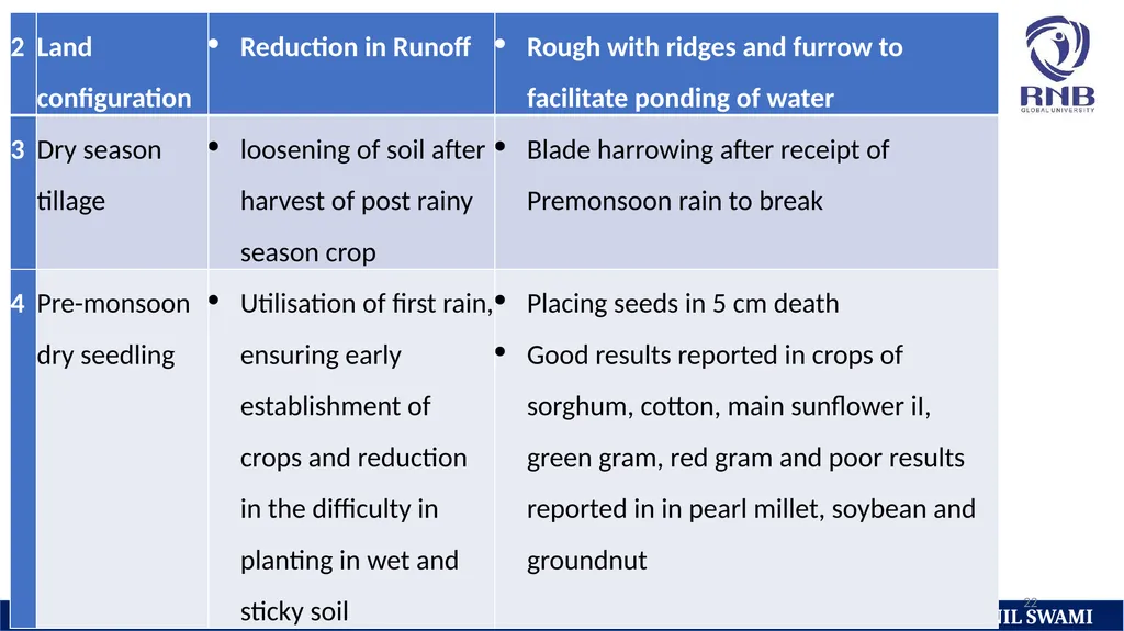
22<br>
23
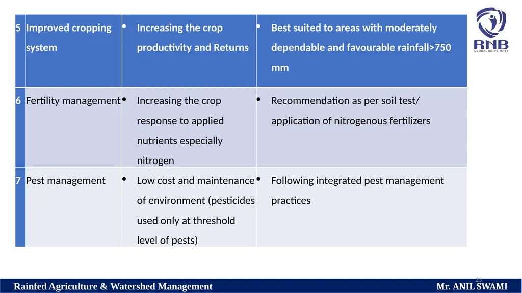
23<br>
24
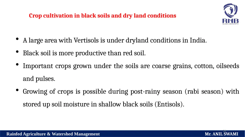
24 Crop cultivation in black soils and dry land conditions A large area with Vertisols is under dryland conditions in India.
Black soil is more productive than red soil.
Important crops grown under the soils are coarse grains, cotton, oilseeds and pulses.
Growing of crops is possible during post-rainy season (rabi season) with stored up soil moisture in shallow black soils (Entisols).<br>
Black soil is more productive than red soil.
Important crops grown under the soils are coarse grains, cotton, oilseeds and pulses.
Growing of crops is possible during post-rainy season (rabi season) with stored up soil moisture in shallow black soils (Entisols).<br>
25
25 In case of medium and deep black soils (i.e. Vertisols/ Inceptisols), growing crops is possible in season and post rainy season which stored up soil moisture (double cropping) depending on the quantity and distribution of rainfall.
Cotton, Sorghum and other millets, pulses; especially chickpea, chillies, sunflower, safflower and coriander are suitable crops.<br>
Cotton, Sorghum and other millets, pulses; especially chickpea, chillies, sunflower, safflower and coriander are suitable crops.<br>
26
26 Laterite soils (Ultisols)
Laterite soils are well-drained soil with good hydraulic conductivity.
They are formed by soil forming process called laterization.
Laterite is a geological term, which means literally rock.
Under high rainfall conditions, silica is released and leached downwards and upper horizons of the soil become rich in oxides of iron and Aluminium.<br>
27
27 This process is called laterization .
Laterites are subdivided into high and low level laterites.
High level laterites are found capping the summits of hills and plateau of the high lands and they are not useful for agriculture as they are thin and gravely.<br>
Laterites are subdivided into high and low level laterites.
High level laterites are found capping the summits of hills and plateau of the high lands and they are not useful for agriculture as they are thin and gravely.<br>
28
28 Low level laterites comprising of clay and loam occur in coastal regions on both sides of the peninsular region and are of considerable agricultural importance.
Laterization is intensified with increase in rainfall with low intensity.<br>
Laterization is intensified with increase in rainfall with low intensity.<br>
29
29 Texture of a laterite soil is generally loam in top layers and depth of the loamy layer varies and in eroded nature.
These soils are Pale, gritty, shallow and poor in plant nutrients in top layer.
Soils in lower layers are of fine texture, darker and rich in plant nutrients and organic matter.
All laterite soils are very poor in base materials like calcium and magnesium.
The pH of the soil is low and acidic in nature.<br>
30
30 Soil clay type is generally kaolinite with traces of illite.
Most of the laterite soils are classified under the order ultisols.
These soils are well developed on the summits of Hills of the Deccan, Karnataka, Kerala and Madhya Pradesh, the Ghat regions of Orissa, Maharashtra, Kerala, West Bengal, Tamil Nadu and Assam.<br>
Most of the laterite soils are classified under the order ultisols.
These soils are well developed on the summits of Hills of the Deccan, Karnataka, Kerala and Madhya Pradesh, the Ghat regions of Orissa, Maharashtra, Kerala, West Bengal, Tamil Nadu and Assam.<br>
31
31 Crop cultivation in laterite soils under dry land conditions
At lower elevations, suitable crops for cultivation under dryland conditions are rice (either single or double cropping), minor millets, trees and shrubs.
Soil and moisture conservation measures may become necessary in regions of low to medium rainfall.
At higher elevation in laterite soil plantation crops like tea, coffee, cinchona, rubber and cashew are grown.<br>
32
32 Desert soil (Aridisols)
These soils occur in hot desert region in India. Rainfall of the region is ranging from as low as 50 mm to the highest of 400 mm of which the major portion is received during monsoon season.
Potential evapo-transpiration is very high and showing aridity.<br>
These soils occur in hot desert region in India. Rainfall of the region is ranging from as low as 50 mm to the highest of 400 mm of which the major portion is received during monsoon season.
Potential evapo-transpiration is very high and showing aridity.<br>
33
33 A major part of the region consists of sand dunes and undulations.
A zone of accumulation of lime concretions at a depth of 60 to 120 cm and presence of alkaline earth carbonate are common futures of this type of soils.
Clay content is very low ranging between 2 to 8% and presence of sodium clay make the soil susceptible to dispersion and less permeable.<br>
A zone of accumulation of lime concretions at a depth of 60 to 120 cm and presence of alkaline earth carbonate are common futures of this type of soils.
Clay content is very low ranging between 2 to 8% and presence of sodium clay make the soil susceptible to dispersion and less permeable.<br>
34
34 The pH of the soil ranges from 8 to 9. Clay type is illite with small amounts of kaolinite.
Desert soils are classified under the order Aridisols.
These soils are distributed in the regions of Rajasthan, southern Haryana and Punjab and northern Gujarat.<br>
Desert soils are classified under the order Aridisols.
These soils are distributed in the regions of Rajasthan, southern Haryana and Punjab and northern Gujarat.<br>
35
35 Crop cultivation in desert soils under dryland conditions
Soils are light textured and the moisture holding capacity and nutrient availability are less.
They are generally poor in available nitrogen and phosphorus.
Soil salinity is a common problem and effective soil depth is influenced by the presence of calcium and carbonate concretions at various depth.
Crop cultivation is possible only in deep soils either during kharif or rabi season based on the rainfall quantity and its distribution.<br>
36
36 Sub-Montane Soils
Sub-montane soils occur in undulating lands of sub Himalayan regions under coniferous forest.
Regions with sub-montane soils are characterized by high rainfall, accumulation of organic matter, absence of free lime and acidic nature.
Landslides and soil erosion arecommon problems associated with sub-montane soils which lead to the leaching of bases.<br>
37
37 Crop cultivation in sub-montane soils under dry land conditions
Soil moisture storage varies from 20 to 30 cm per metre soil profile.
As the regions are characterized by high rainfall, double cropping is possible in sub-montane soils.
Soils are low in available nitrogen and phosphorus and crops respond well to the application of N and P for higher productivity.<br>
38
38 Saline and sodic soils
Saline and sodic soils occur mainly in arid and semi-arid regions of the country where the annual temperature are high and rate of evaporation generally exceeds rainfall.
The situation leads to accumulation of salts in surface layers of the soil.
In India, such soils are spreading over 8.5 million hectare of land and they are found with poor organic carbon, available nitrogen and Zinc.<br>
39
39 Saline soils contain excessively soluble salts and the dominant soil type are chlorides and sulphates of sodium, magnesium and Calcium.
Total salt concentration as expressed by soil EC is generally more than 4 dS/ m.
These soils are associated with water logging, saline groundwater and aridity.<br>
Total salt concentration as expressed by soil EC is generally more than 4 dS/ m.
These soils are associated with water logging, saline groundwater and aridity.<br>
40
40 Sodic soils generally contain salts of carbonates and bicarbonates of sodium where the soil EC will be less than 4 dS/m and exchangeable sodium percentage more than 15%.
These soils can be observed with stagnation of muddy water after rain for many days and they are very hard when dry and very soft when wet.
Sodic soils contain insoluble calcium carbonate at high pH level (>9.5).<br>
These soils can be observed with stagnation of muddy water after rain for many days and they are very hard when dry and very soft when wet.
Sodic soils contain insoluble calcium carbonate at high pH level (>9.5).<br>
41
41 Crop cultivation in saline sodic soils under dry farming conditions
Reclamation Technologies for growing crops in Salt affected soil differ depending upon the availability of source of water.
For areas which depend only on rainfall as the source of moisture, cultivation of salt tolerant plants species and planting techniques are recommended.
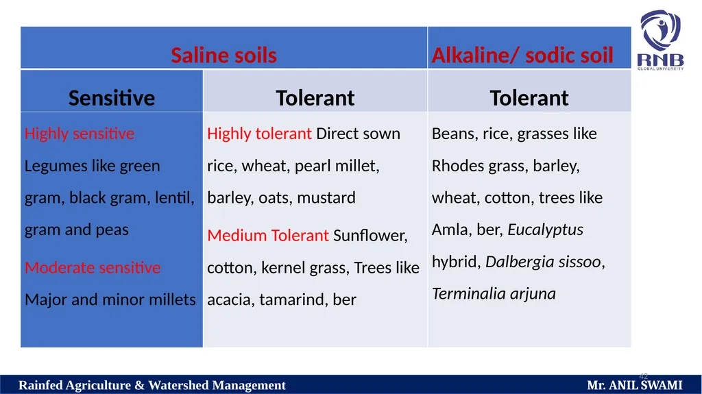
Crops have been identified to salt stress conditions and few such crops which are sensitive and tolerant to soil salinity and sodicity under dry land conditions are given in table<br>
42
42<br>
43
43 Climate
The behaviour of atmospheric phenomenon at a given place and time is defined as weather and the composite day-to-day weather elements for a given place or region over a period is referred as climate.<br>
The behaviour of atmospheric phenomenon at a given place and time is defined as weather and the composite day-to-day weather elements for a given place or region over a period is referred as climate.<br>
44
44 Dry climate
A dry climate is one in which the average annual precipitation is definition in relation to evaporation.
It can be divided into arid and semi-arid climate.<br>
A dry climate is one in which the average annual precipitation is definition in relation to evaporation.
It can be divided into arid and semi-arid climate.<br>
45
45 Arid climate
It can be defined as an extreme dry climate where the average annual precipitation is less than 500 mm and usually in the range of 250 to 500 mm.
Generally, the rainfall is well short of evapotranspiration demand of the atmosphere.
The precipitation is insufficient for crop production.<br>
It can be defined as an extreme dry climate where the average annual precipitation is less than 500 mm and usually in the range of 250 to 500 mm.
Generally, the rainfall is well short of evapotranspiration demand of the atmosphere.
The precipitation is insufficient for crop production.<br>
46
46 Semi-arid climate
It can be defined as a climate where the average annual precipitation is greater than 500 mm and generally, crop production is possible with dry farming methods or with supplemental irrigation.
The tropical retreat and semi-arid climate I have many features in common the distinct character of this climate is lake of sufficient rainfall to sustain crop production.
They are centre on the latitudes from 20 to 25 degree north and South.<br>
47
47 Climate largely limits crop and animal production, ensures the human comfort, influences on health determine clothing and housing etc.
Its influence on agriculture is enormous throughout the world and in a country like India where agriculture is the backbone of development, importance is manifold.
The success of failure of farming is closely related to the prevailing weather condition.<br>
Its influence on agriculture is enormous throughout the world and in a country like India where agriculture is the backbone of development, importance is manifold.
The success of failure of farming is closely related to the prevailing weather condition.<br>
48
48 However, there are possibilities to optimise farm production by existing cropping pattern and agronomic practices to suit the climate of a locality.
Weather resumes significance in nearly every phase of Agricultural activity from the preparatory tillage to harvesting and storage.
Therefore, a sound knowledge of climate factors and an understanding of the complex processes of interaction between the climate and the biological processes of the plants are essential to a scientific approach on farming.
The principal climatic factors limiting crop production in the order of priority under dryland conditions are precipitation temperature, sunlight, wind length of growing season etc.<br>
49
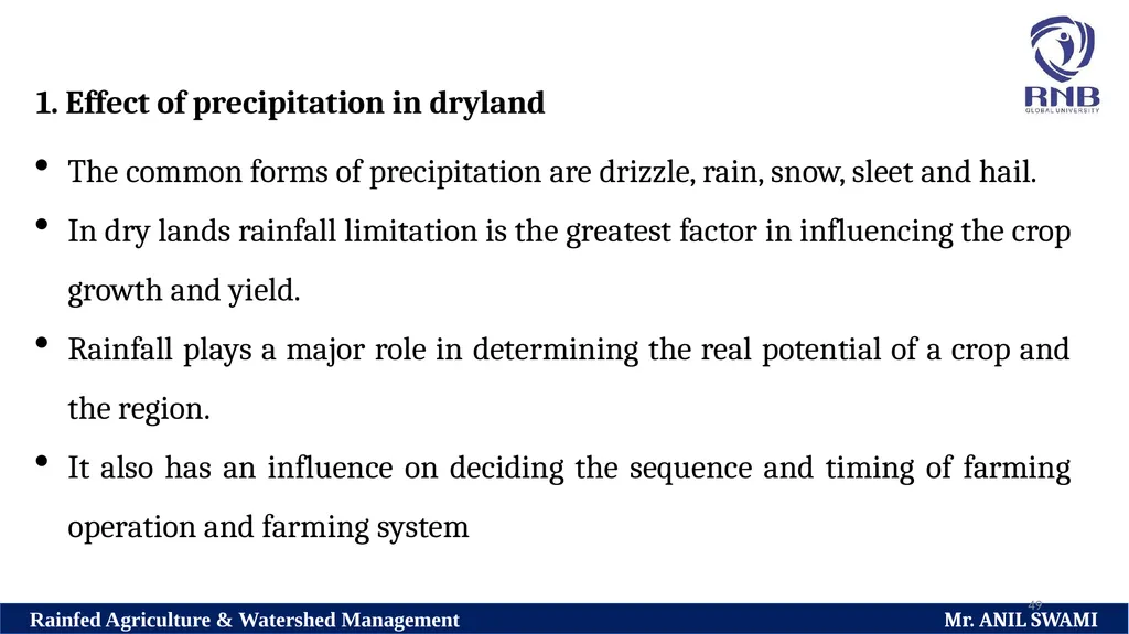
49 1. Effect of precipitation in dryland
The common forms of precipitation are drizzle, rain, snow, sleet and hail.
In dry lands rainfall limitation is the greatest factor in influencing the crop growth and yield.
Rainfall plays a major role in determining the real potential of a crop and the region.
It also has an influence on deciding the sequence and timing of farming operation and farming system<br>
50
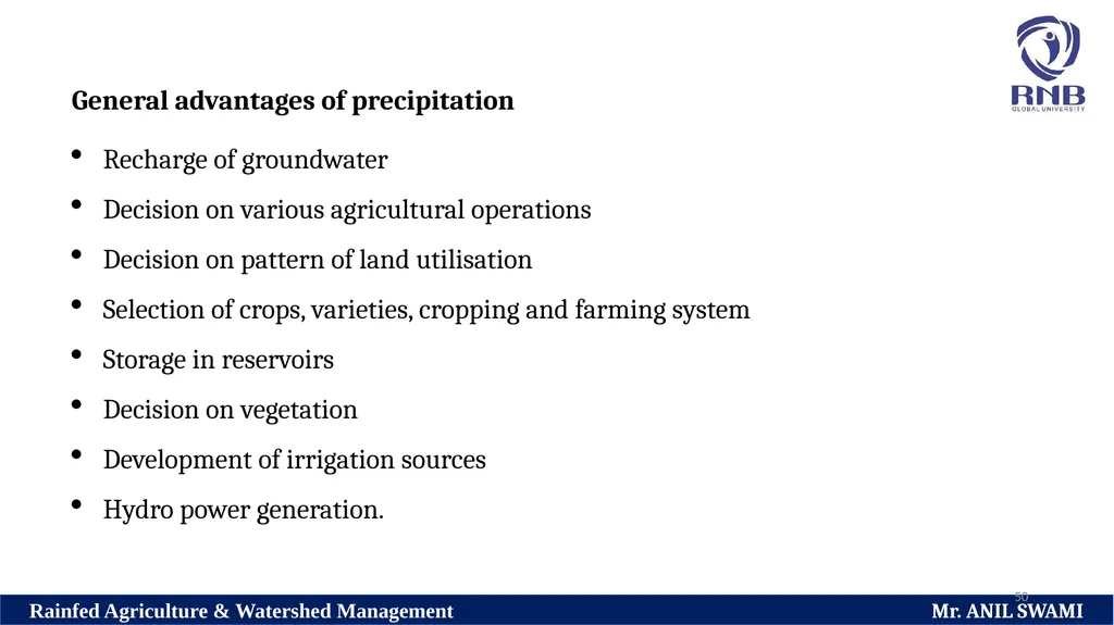
50 General advantages of precipitation
Recharge of groundwater
Decision on various agricultural operations
Decision on pattern of land utilisation
Selection of crops, varieties, cropping and farming system
Storage in reservoirs
Decision on vegetation
Development of irrigation sources
Hydro power generation.<br>
Recharge of groundwater
Decision on various agricultural operations
Decision on pattern of land utilisation
Selection of crops, varieties, cropping and farming system
Storage in reservoirs
Decision on vegetation
Development of irrigation sources
Hydro power generation.<br>
51
51 Forms of precipitation and their effect on crop growth.
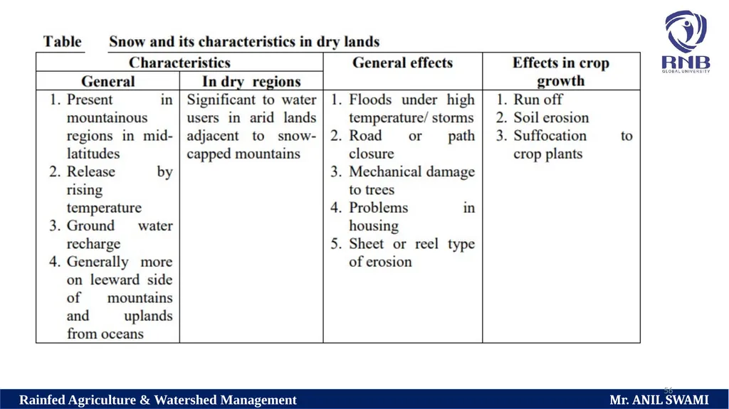
General forms of precipitation are rainfall, snow and hail. Their common characteristics in dry regions and its effects on crop growth are discussed as under.<br>
General forms of precipitation are rainfall, snow and hail. Their common characteristics in dry regions and its effects on crop growth are discussed as under.<br>
52
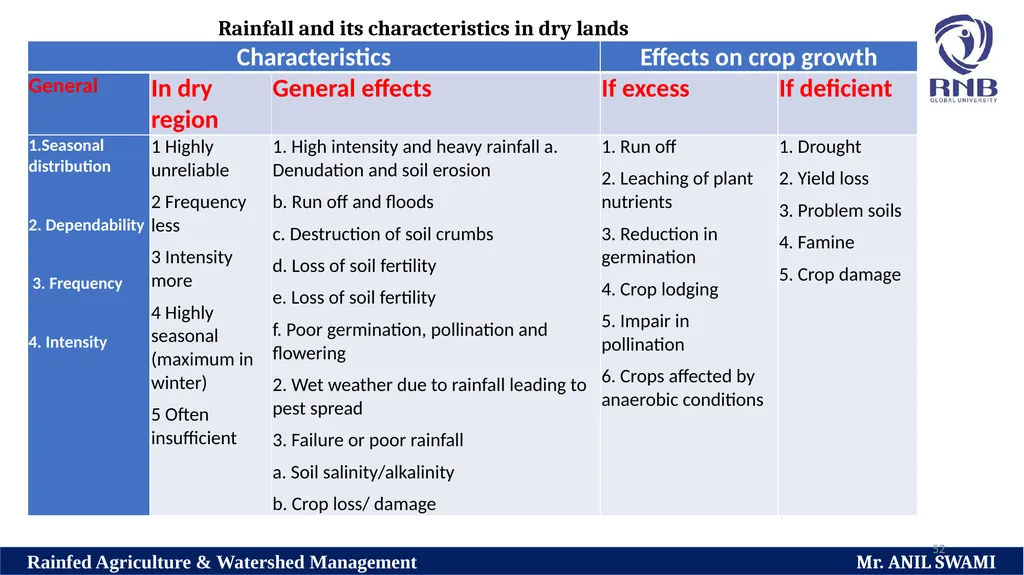
52 Rainfall and its characteristics in dry lands<br>
53
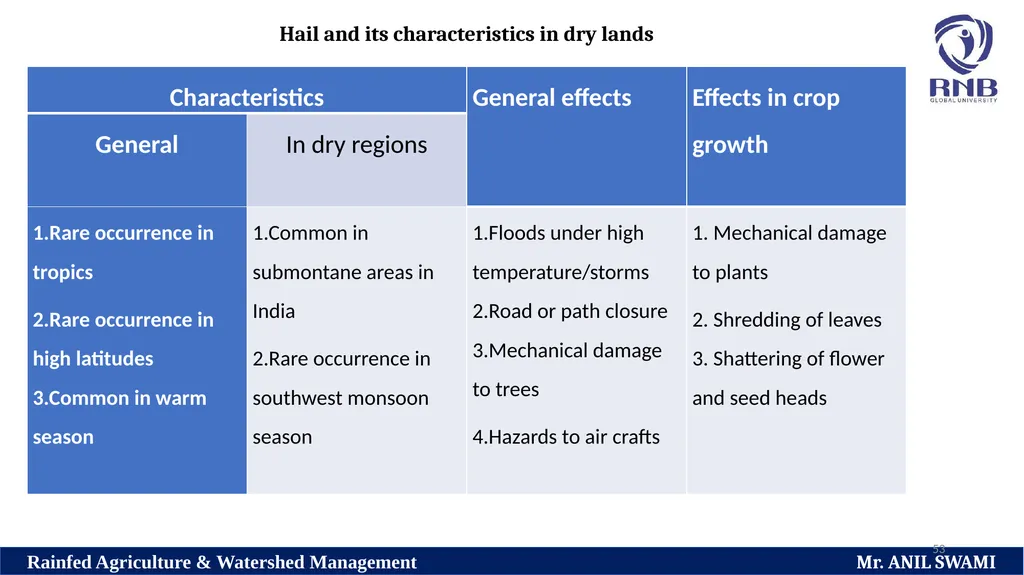
53 Hail and its characteristics in dry lands<br>
54
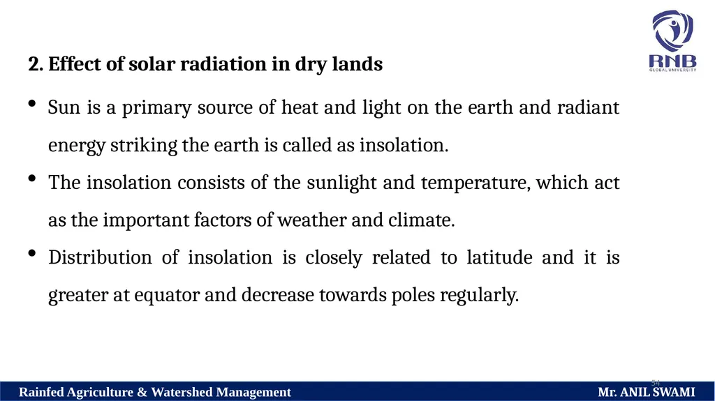
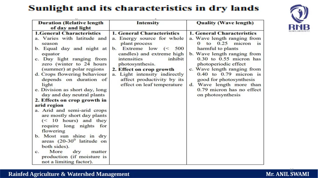
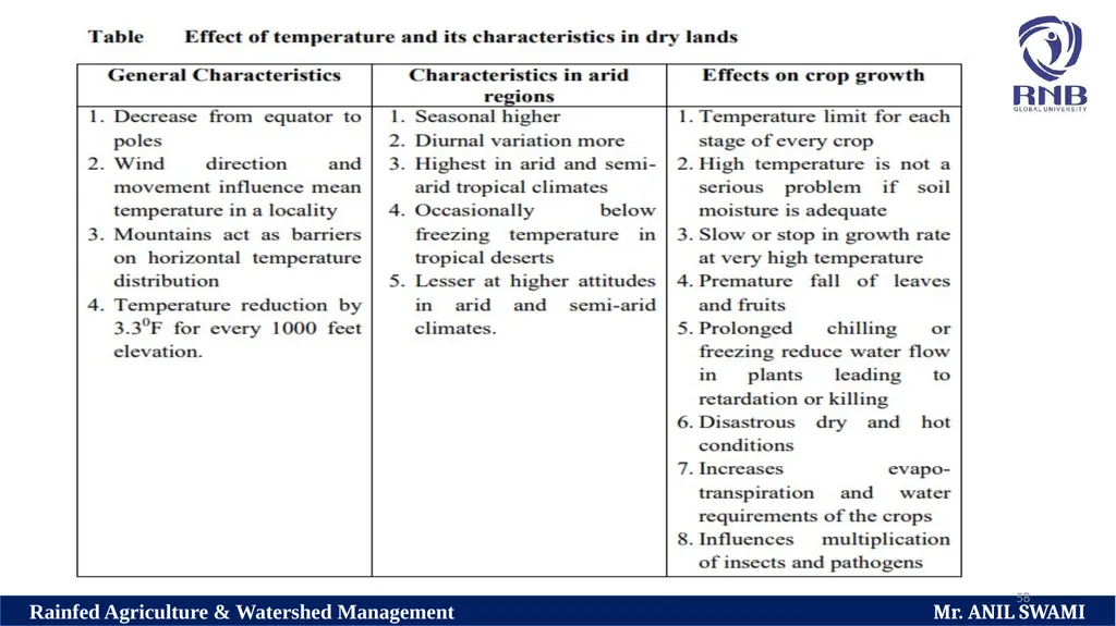
54 2. Effect of solar radiation in dry lands
Sun is a primary source of heat and light on the earth and radiant energy striking the earth is called as insolation.
The insolation consists of the sunlight and temperature, which act as the important factors of weather and climate.
Distribution of insolation is closely related to latitude and it is greater at equator and decrease towards poles regularly.<br>
55
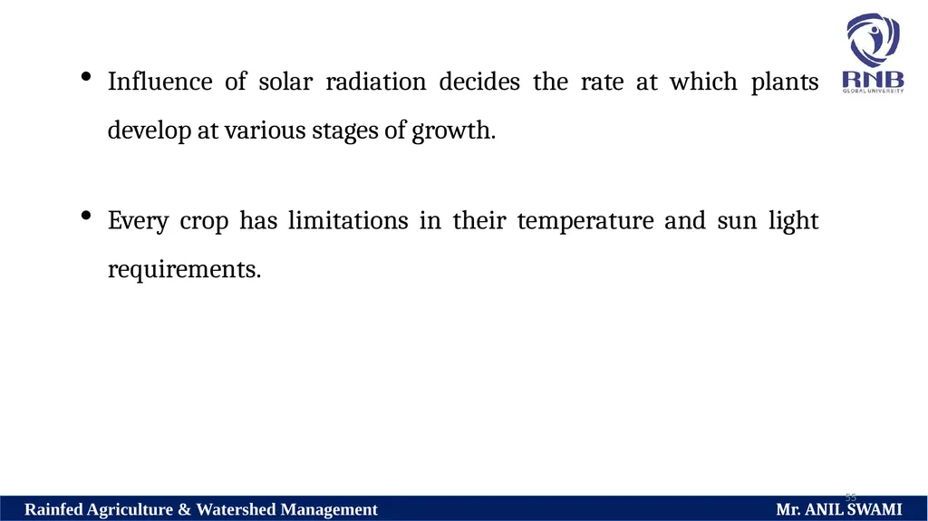
55 Influence of solar radiation decides the rate at which plants develop at various stages of growth.
Every crop has limitations in their temperature and sun light requirements.<br>
Every crop has limitations in their temperature and sun light requirements.<br>
56
56<br>
57
57<br>
58
58<br>
59
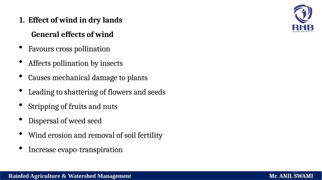
59 Effect of wind in dry lands
General effects of wind
Favours cross pollination
Affects pollination by insects
Causes mechanical damage to plants
Leading to shattering of flowers and seeds
Stripping of fruits and nuts
Dispersal of weed seed
Wind erosion and removal of soil fertility
Increase evapo-transpiration<br>
General effects of wind
Favours cross pollination
Affects pollination by insects
Causes mechanical damage to plants
Leading to shattering of flowers and seeds
Stripping of fruits and nuts
Dispersal of weed seed
Wind erosion and removal of soil fertility
Increase evapo-transpiration<br>
60
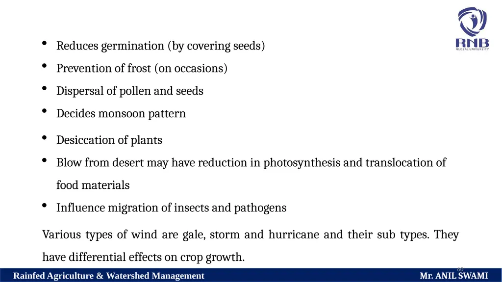
60 Reduces germination (by covering seeds)
Prevention of frost (on occasions)
Dispersal of pollen and seeds
Decides monsoon pattern
Desiccation of plants
Blow from desert may have reduction in photosynthesis and translocation of food materials
Influence migration of insects and pathogens
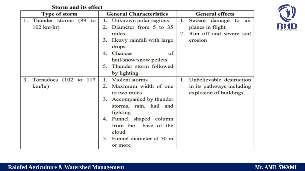
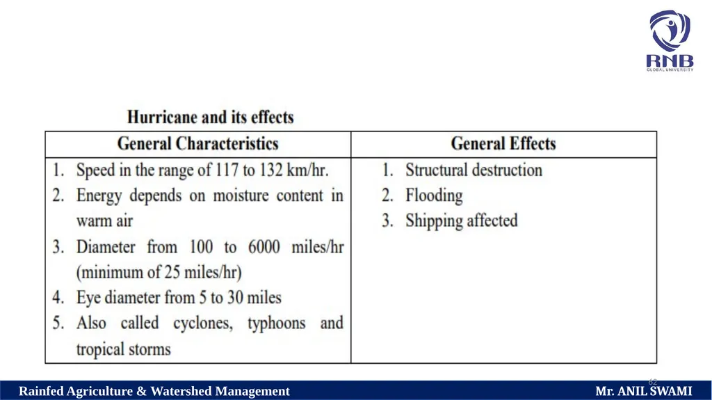
Various types of wind are gale, storm and hurricane and their sub types. They have differential effects on crop growth.<br>
61
61<br>
62
62<br>
63
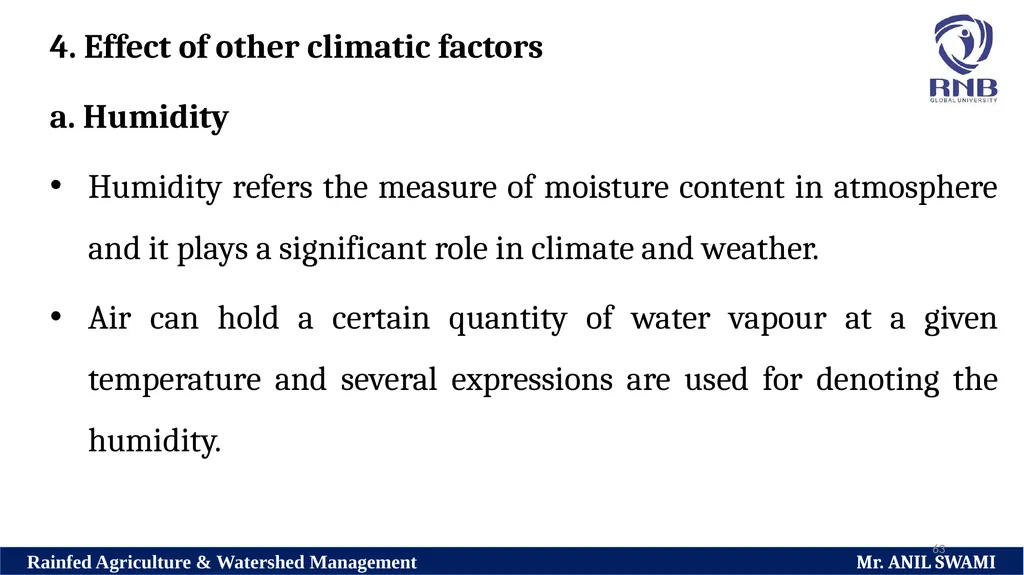
63 4. Effect of other climatic factors
a. Humidity
Humidity refers the measure of moisture content in atmosphere and it plays a significant role in climate and weather.
Air can hold a certain quantity of water vapour at a given temperature and several expressions are used for denoting the humidity.<br>
a. Humidity
Humidity refers the measure of moisture content in atmosphere and it plays a significant role in climate and weather.
Air can hold a certain quantity of water vapour at a given temperature and several expressions are used for denoting the humidity.<br>
64
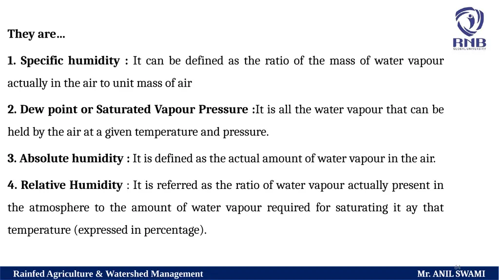
64 They are…
1. Specific humidity : It can be defined as the ratio of the mass of water vapour actually in the air to unit mass of air
2. Dew point or Saturated Vapour Pressure :It is all the water vapour that can be held by the air at a given temperature and pressure.
3. Absolute humidity : It is defined as the actual amount of water vapour in the air.
4. Relative Humidity : It is referred as the ratio of water vapour actually present in the atmosphere to the amount of water vapour required for saturating it ay that temperature (expressed in percentage).<br>
65
65 Among these expressions, the best known and mostly used reference to water vapour is relative humidity (RH%) and it is found to be maximum during early morning hours and the minimum is afternoon.<br>
66
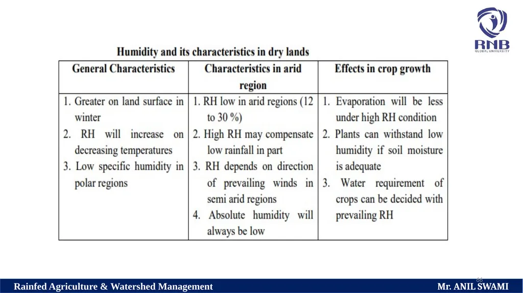
66<br>
67
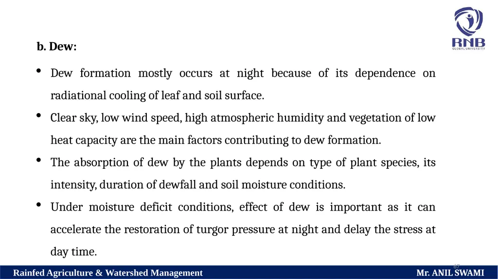
67 b. Dew:
Dew formation mostly occurs at night because of its dependence on radiational cooling of leaf and soil surface.
Clear sky, low wind speed, high atmospheric humidity and vegetation of low heat capacity are the main factors contributing to dew formation.
The absorption of dew by the plants depends on type of plant species, its intensity, duration of dewfall and soil moisture conditions.
Under moisture deficit conditions, effect of dew is important as it can accelerate the restoration of turgor pressure at night and delay the stress at day time.<br>
68
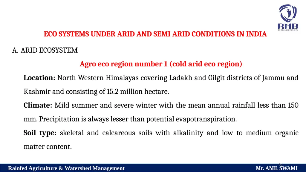
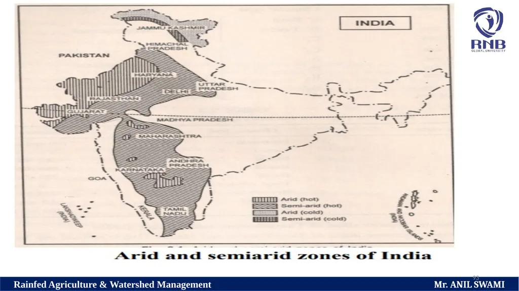
68 ECO SYSTEMS UNDER ARID AND SEMI ARID CONDITIONS IN INDIA
ARID ECOSYSTEM
Agro eco region number 1 (cold arid eco region)
Location: North Western Himalayas covering Ladakh and Gilgit districts of Jammu and Kashmir and consisting of 15.2 million hectare.
Climate: Mild summer and severe winter with the mean annual rainfall less than 150 mm. Precipitation is always lesser than potential evapotranspiration.
Soil type: skeletal and calcareous soils with alkalinity and low to medium organic matter content.<br>
69
69 Rain: Water vapour condenses around condensation nuclei (such as dust) and falls when the droplet is heavy enough.
Sleet: Same formation as rain, but it freezes somewhere along its path from the clouds to the ground. Sleet is a mixture of snow and rain.
Snow: Water droplets form and then freezing occurs slowly, allowing for the development of uniquely designed ice crystals know as snow. Snow is formed when water vapour is deposited in the higher reaches of the atmosphere at a temperature less than zero degrees Centigrade, and then falls to the ground.<br>
70
70 Snowflakes are typically symmetrical, hexagonally shaped groups of ice crystals that form while falling in and below clouds.
Simply put - Snow forms if the air in a cloud is below freezing.
The water vapour then turns to ice instead of rain and the tiny ice crystals stick together until they form snowflakes.
When they get heavy enough to fall, they drop out of the clouds.
At this point though, we still don’t know whether they will end up as rain or remain as snow.<br>
71
71 This depends on the temperature of the air they travel through on the way down to the ground.
If it gets warmer, they turn into rain, but if the air stays close to freezing all the way down, then the snowflakes will make it without melting and so fall as snow.
If this occurs in a mountain area, it is possible for snow to be falling on the mountaintop while lower down in the valley the air is warmer and so it is raining instead.<br>
72
72 Hail: Water droplets are carried high into the atmosphere by thunderstorm updrafts, which cause them to freeze. Multiple drops tend to freeze together, which is why the diameter of hail can be large.
Dew: Water vapour on the ground condenses on objects such as blades of grass when the surface temperature is equal to the dew point
Frost: Dew forms and then it freezes. This commonly occurs when nigh time. Radiational cooling drops the ground temperature down enough. There are three kinds of frost: Delicate crystallized ice on windowpanes is called Hoar frost.<br>
73
73 Glazed frost consists of thick coatings of ice on cold surfaces. Rime frost is formed when super-cooled water droplets freeze on contact with cold surfaces. It often occurs when freezing fogs or drizzle blanket the ground.
Freezing rain: Forms and falls as rain. At the surface or near the surface, the temperature is at or below freezing, which causes the rain to freeze on contact.
Fog: A thin cloud of varying size formed at the surface of the earth by condensation of atmospheric vapour.
Mist: A very thin fog.
Drizzle: A light steady rain in fine drops (0.5 mm) and intensity < 1 mm/hr.<br>
74
74 Land use: Sparse forest trees. Regular cropping programs include vegetables, millet, wheat, fodder, pulses, barley and fruit crops like apple and apricot.
Livestock: Dominated by mule and followed by sheep, goat and yak rearing.
Constraints:
Severe climatic conditions limiting crop growth
Length of growing season is less than 90 days in a year which limits crop production
Nutrient imbalance due to Sandy and gravelly and moderate to calcareous soil<br>
75
75 Potential of the region
Dry fruit crops apricot and off season vegetables peas
Agro Eco region number 2 (Hot arid eco region 1)
Location : South western part of Punjab and Haryana, Western parts of Rajasthan, kKutch and North Kathiyawad Peninsula in Gujarat. Area under this Zone extends to 31.9 million hectares.<br>
Dry fruit crops apricot and off season vegetables peas
Agro Eco region number 2 (Hot arid eco region 1)
Location : South western part of Punjab and Haryana, Western parts of Rajasthan, kKutch and North Kathiyawad Peninsula in Gujarat. Area under this Zone extends to 31.9 million hectares.<br>
76
76 Climate: Hot summer and cold winters with a minimum annual rainfall less than 400 mm. Potential evapotranspiration demand ranges between 1500 and 2000 mm annually. Length of growing season is less than 90 days per year.
Soil type: Desert and Sandy soils with calcareous and alkaline nature
Vegetation and cropping pattern: Drastically reduced, spares and tropical thorn forest. Rainfed mono-cropping with short duration crops like pearl millet and pulses. In irrigated land crops like sugar cane, cotton, mustard, gram and wheat are grown.<br>
77
77 Constraints:
Indiscriminate deforestation
Scanty and Erratic rainfall pattern leading to draught at critical stages of Crop growth
Soil salinity and nutrient imbalance Potential of the zone
Developing irrigation sources can further increase the productivity
Dryland Agroforestry and forestry may sustain the productivity<br>
78
78 Agro Eco region number 3 (Hot arid eco region 2)
Location: Deccan Plateau covering the districts of Bellary , Tumkur, North Chitradurga, South west parts of Bijapur, Raichur of Karnataka and Anantapur of Andhra Pradesh.
The total spread of the region is 4.9 million hectares.<br>
Location: Deccan Plateau covering the districts of Bellary , Tumkur, North Chitradurga, South west parts of Bijapur, Raichur of Karnataka and Anantapur of Andhra Pradesh.
The total spread of the region is 4.9 million hectares.<br>
79
79 Climate: Hot and dry summer and mild winters with the mean annual rainfall ranging from 400 to 500 mm. Severe drought prone area throughout the year and length of growing period is less than 90 days in a year.
Soil type: Shadow to medium red loam soil and deep clayey black soil<br>
Soil type: Shadow to medium red loam soil and deep clayey black soil<br>
80
80 Vegetation and cropping pattern: Tropical dry deciduous and tropical thorn forests. Irrigated farming includes growing of sugarcane, cotton, safflower and groundnut. Rainfed Mono-cropping is carried out with during rainy season pearl millet or post rainy season with stored residual moisture sorghum or safflower
Constraint:
Soil erosion during rainy season
Poor and ill distributed rainfall and occasional crop failure due to prolonged dry spell
Poor Workability of black soil<br>
Constraint:
Soil erosion during rainy season
Poor and ill distributed rainfall and occasional crop failure due to prolonged dry spell
Poor Workability of black soil<br>
81
81 SEMI ARID ECOSYSTEM
Agro Eco region number 4 (Hot semi-arid eco region 1)
Location: Parts of Gujarat (5 districts), Haryana (8 districts), Punjab (7 districts), Union Territory of Delhi, Uttar Pradesh (29 districts) and Rajasthan (11 districts). This region extends to 2.2 million hectares.
Climate: Hot and dry summers and cold winters with the mean annual rainfall ranging between 500 to 1000 mm. Length of growing period is 90 to 150 days in a year.<br>
82
82 Soil type: Course to fine loam and sand dunes
Vegetation and cropping pattern: Tropical deciduous and tropical thorn forest. Irrigated farming is followed in 65% of the total cultivable area and the crops cultivated are wheat, rice, millet, maize, pulses, berseem, mustard and sugarcane. Rainfed agriculture is followed in 35% of the area with mono-cropping of seasonal crops like sorghum, soybean and pigeon pea and post seasonal crops like ok pulses, lentil and wheat on residual moisture.<br>
Vegetation and cropping pattern: Tropical deciduous and tropical thorn forest. Irrigated farming is followed in 65% of the total cultivable area and the crops cultivated are wheat, rice, millet, maize, pulses, berseem, mustard and sugarcane. Rainfed agriculture is followed in 35% of the area with mono-cropping of seasonal crops like sorghum, soybean and pigeon pea and post seasonal crops like ok pulses, lentil and wheat on residual moisture.<br>
83
83 Constraints:
Nature of soil with low water holding capacity
Lowering water table
Salinity and sodicity due to in perfect drainage condition
Potential of the region:
Introduction of irrigation facilities and changes in cropping pattern from low value crops like millets to high value crops like cotton, sugarcane and wheat
Crop diversification to oil seeds<br>
84
84 Agro Eco region number 5 (Hot semi-arid eco region 2)
Location: Western Madhya Pradesh (10 districts), South Eastern parts of Rajasthan (5 districts) and Gujarat (10 districts) and Union Territory of Diu. This zone covers 17.6 million hectares.
Climate: Hot and wet summer and cold winter with a mean annual rainfall of 500 to 1000 mm and the length of growing period 90 to 150 days. Certain districts of the states of Madhya Pradesh, Rajasthan and Gujarat are prone to drought once in three years.
Soil type: Deep loam to clay and black soils. Coastal areas in Gujarat have clay and sandy soils with slight alkalinity.<br>
85
85 Vegetation and cropping pattern: This region is characterized by dry deciduous forest. Dry farming is practised in most areas with kharif crops like sorghum, pearl millet, pigeon pea, groundnut, soybean, maize and pulses and with Rabi crops like safflower, sunflower and gram
Constraints:
Intermittent or occasional drought occurrence
Soil salinity or alkalinity due to imperfect drainage or inundation of seawater leading to crop failure
Potential of the region:
Development through minor irrigation project
Forestry and dryland horticulture activities<br>
Constraints:
Intermittent or occasional drought occurrence
Soil salinity or alkalinity due to imperfect drainage or inundation of seawater leading to crop failure
Potential of the region:
Development through minor irrigation project
Forestry and dryland horticulture activities<br>
86
86 Agro Eco region number 6 (hot semi-arid eco region 3)
Location: Western parts of Maharashtra (20 districts), Northern parts of Karnataka (6 districts) and Western parts of Andhra Pradesh (2 districts). The zone spreads over 31 million hectares.
Climate: Hot and humid summer and mild and dry winter with an annual rainfall of 600 to 1000 mm. Length of growing period is between 90 and 150 days. Some districts are drought prone and the drought spell may be severe once in 3 years.
Soil type: Shallow loam to Clay soils with calcareous or alkaline nature<br>
87
87 Vegetation and cropping pattern: The region is found with tropical dry deciduous tropical thorn forest. Mono-cropping is followed under rainfed condition with kharif crops like pearl millet or post rainy season crops like safflower and sunflower. With irrigation facilities crops like cotton and groundnut are grown.
Constraints :
Prolonged dry spells leading to reduced growth and crop failure
Soil erosion
Nutrient imbalance in soil
Potential of the region :
Achievable high productivity with better water management practices
Dryland Agroforestry and horticulture<br>
Constraints :
Prolonged dry spells leading to reduced growth and crop failure
Soil erosion
Nutrient imbalance in soil
Potential of the region :
Achievable high productivity with better water management practices
Dryland Agroforestry and horticulture<br>
88
88 Agro Eco region number 7 (Hot semi-arid eco region 4)
Location: Deccan Plateau and Eastern parts of Andhra Pradesh (14 districts). This region spreads over 16.5 million hectares.
Climate : Hot and moist summer and mild and dry winter with the mean annual rainfall of 600 to 1100 mm. Length of the growing period is ranging between 90 and 150 days in a year. In this zone 6 districts are prone to drought.
Soil type: Black cotton soils are calcareous and strong alkaline in nature. Isolated track are found with red soils, which is non-calcareous and neutral in reaction.<br>
89
89 Vegetation and cropping pattern : Tropical dry deciduous and thorny forest. Traditional farming under rainfed condition is followed with kharif crops like sorghum, cotton, pigeon pea, rice, groundnut and castor and rabi crops like sorghum, sunflower, safflower and other oil seeds, rice is the major crop under irrigated condition.
Constraint:
Soil erosion due to high runoff leading to loss of soil and nutrients
Crop failure due to frequent drought under rainfed condition
Imperfect drainage under irrigated conditions leading to salinity and sodicity
Potential of the region:
Achievable high productivity with better water management practices
Dryland Agroforestry and horticulture
Watershed program<br>
90
90 Agro Eco region number 8 (Hot semi-arid eco region 5 )
Location: Eastern Ghats and Southern parts of Deccan Plateau covering the parts of Andhra Pradesh (one district), Karnataka (9 districts) and Tamil Nadu (15 districts) and extending over an area of 19.1 million hectares.
Climate: Hot and dry summer and mild winter with a mean annual rainfall of 600 to 1000 mm and the length of growing period is 90 to 150 days in a year. Parts of Karnataka receive rainfall in summer season and rest of the region receives rain during winter.<br>
91
91 Soil type: Red loamy soil
Vegetation and cropping pattern: Tropical dry deciduous and thorny forest. Under irrigated conditions, cotton, sugar cane and rice are the major crops. Rainfed cultivation is the traditional practice with crops like millets, pulses and oilseeds especially groundnut in kharif season and with crops like sorghum and oilseeds especially safflower in Karnataka in Rabi season.
Constraints:
Severity of soil erosion
Severity of drought due to poor moisture holding capacity of soil
Potential of the region:
Dryland Horticulture with suitable fruit crops
Floriculture under irrigated condition<br>
92
92<br>
93
93<br>
94
Thank You 94 Rainfed Agriculture & Watershed Management Mr. ANIL SWAMI<br>