
The African Monsoon Recent Evolution and Current
PC
Published · 12 slides · 0 views
1 / 1

Description
The African Monsoon Recent Evolution and Current Status Include Week-1 and Week-2 Outlooks Update prepared 02 September 2025 For more information, visit:
Related Topics
Share
Embed code
Download this presentation From Below
"The African Monsoon Recent Evolution and Current" is the property of its rightful owner. Permission is granted to download and print the materials on this website for personal, non-commercial use only, and to display it on your personal computer provided you do not modify the materials and that you retain all copyright notices contained in the materials. By downloading content from our website, you accept the terms of this agreement.
Presentation Transcript
01
The African Monsoon Recent Evolution and Current Status
Include Week-1 and Week-2 Outlooks Update prepared
02 September 2025 For more information, visit:
http://www.cpc.ncep.noaa.gov/products/Global_Monsoons/African_Monsoons/precip_monitoring.shtml<br>
02 September 2025 For more information, visit:
http://www.cpc.ncep.noaa.gov/products/Global_Monsoons/African_Monsoons/precip_monitoring.shtml<br>
02
Outline Highlights
Recent Evolution and Current Conditions
NCEP GEFS Forecasts
Summary<br>
Recent Evolution and Current Conditions
NCEP GEFS Forecasts
Summary<br>
03
Highlights:
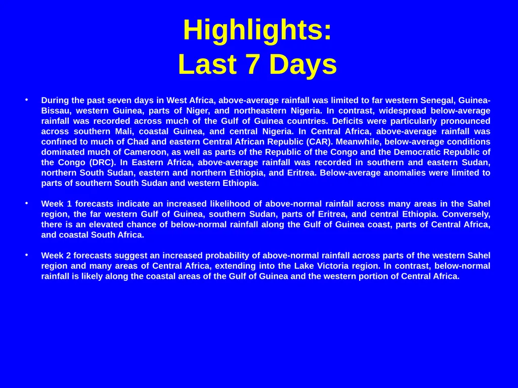
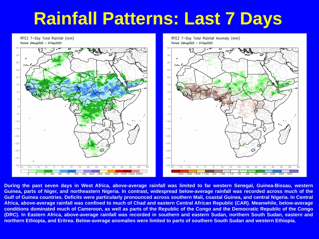
Last 7 Days During the past seven days in West Africa, above-average rainfall was limited to far western Senegal, Guinea-Bissau, western Guinea, parts of Niger, and northeastern Nigeria. In contrast, widespread below-average rainfall was recorded across much of the Gulf of Guinea countries. Deficits were particularly pronounced across southern Mali, coastal Guinea, and central Nigeria. In Central Africa, above-average rainfall was confined to much of Chad and eastern Central African Republic (CAR). Meanwhile, below-average conditions dominated much of Cameroon, as well as parts of the Republic of the Congo and the Democratic Republic of the Congo (DRC). In Eastern Africa, above-average rainfall was recorded in southern and eastern Sudan, northern South Sudan, eastern and northern Ethiopia, and Eritrea. Below-average anomalies were limited to parts of southern South Sudan and western Ethiopia.
Week 1 forecasts indicate an increased likelihood of above-normal rainfall across many areas in the Sahel region, the far western Gulf of Guinea, southern Sudan, parts of Eritrea, and central Ethiopia. Conversely, there is an elevated chance of below-normal rainfall along the Gulf of Guinea coast, parts of Central Africa, and coastal South Africa.
Week 2 forecasts suggest an increased probability of above-normal rainfall across parts of the western Sahel region and many areas of Central Africa, extending into the Lake Victoria region. In contrast, below-normal rainfall is likely along the coastal areas of the Gulf of Guinea and the western portion of Central Africa.<br>
Week 1 forecasts indicate an increased likelihood of above-normal rainfall across many areas in the Sahel region, the far western Gulf of Guinea, southern Sudan, parts of Eritrea, and central Ethiopia. Conversely, there is an elevated chance of below-normal rainfall along the Gulf of Guinea coast, parts of Central Africa, and coastal South Africa.
Week 2 forecasts suggest an increased probability of above-normal rainfall across parts of the western Sahel region and many areas of Central Africa, extending into the Lake Victoria region. In contrast, below-normal rainfall is likely along the coastal areas of the Gulf of Guinea and the western portion of Central Africa.<br>
04
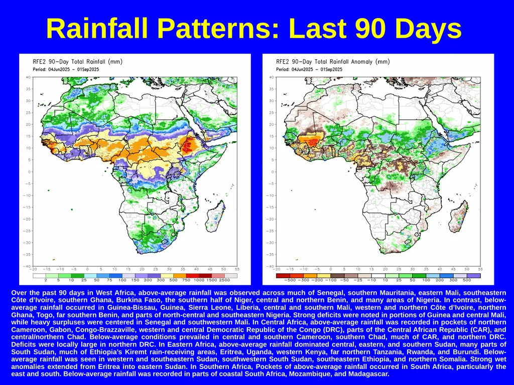
Rainfall Patterns: Last 90 Days Over the past 90 days in West Africa, above-average rainfall was observed across much of Senegal, southern Mauritania, eastern Mali, southeastern Côte d’Ivoire, southern Ghana, Burkina Faso, the southern half of Niger, central and northern Benin, and many areas of Nigeria. In contrast, below-average rainfall occurred in Guinea-Bissau, Guinea, Sierra Leone, Liberia, central and southern Mali, western and northern Côte d’Ivoire, northern Ghana, Togo, far southern Benin, and parts of north-central and southeastern Nigeria. Strong deficits were noted in portions of Guinea and central Mali, while heavy surpluses were centered in Senegal and southwestern Mali. In Central Africa, above-average rainfall was recorded in pockets of northern Cameroon, Gabon, Congo-Brazzaville, western and central Democratic Republic of the Congo (DRC), parts of the Central African Republic (CAR), and central/northern Chad. Below-average conditions prevailed in central and southern Cameroon, southern Chad, much of CAR, and northern DRC. Deficits were locally large in northern DRC. In Eastern Africa, above-average rainfall dominated central, eastern, and southern Sudan, many parts of South Sudan, much of Ethiopia’s Kiremt rain-receiving areas, Eritrea, Uganda, western Kenya, far northern Tanzania, Rwanda, and Burundi. Below-average rainfall was seen in western and southeastern Sudan, southwestern South Sudan, southeastern Ethiopia, and northern Somalia. Strong wet anomalies extended from Eritrea into eastern Sudan. In Southern Africa, Pockets of above-average rainfall occurred in South Africa, particularly the east and south. Below-average rainfall was recorded in parts of coastal South Africa, Mozambique, and Madagascar.<br>
05
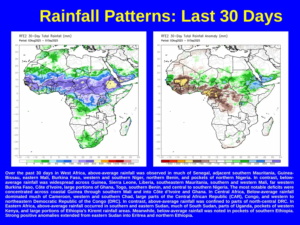
Rainfall Patterns: Last 30 Days Over the past 30 days in West Africa, above-average rainfall was observed in much of Senegal, adjacent southern Mauritania, Guinea-Bissau, eastern Mali, Burkina Faso, western and southern Niger, northern Benin, and pockets of northern Nigeria. In contrast, below-average rainfall was widespread across Guinea, Sierra Leone, Liberia, southeastern Mauritania, southern and western Mali, far western Burkina Faso, Côte d’Ivoire, large portions of Ghana, Togo, southern Benin, and central to southern Nigeria. The most notable deficits were concentrated across coastal Guinea through southern Mali and into Côte d’Ivoire and Ghana. In Central Africa, Below-average rainfall dominated much of Cameroon, western and southern Chad, large parts of the Central African Republic (CAR), Congo, and western to northeastern Democratic Republic of the Congo (DRC). In contrast, above-average rainfall was confined to parts of north-central DRC. In Eastern Africa, above-average rainfall occurred in southern and eastern Sudan, much of South Sudan, parts of Uganda, pockets of western Kenya, and large portions of Ethiopia’s Kiremt rainfall areas. Meanwhile, below-average rainfall was noted in pockets of southern Ethiopia. Strong positive anomalies extended from eastern Sudan into Eritrea and northern Ethiopia.<br>
06
Rainfall Patterns: Last 7 Days During the past seven days in West Africa, above-average rainfall was limited to far western Senegal, Guinea-Bissau, western Guinea, parts of Niger, and northeastern Nigeria. In contrast, widespread below-average rainfall was recorded across much of the Gulf of Guinea countries. Deficits were particularly pronounced across southern Mali, coastal Guinea, and central Nigeria. In Central Africa, above-average rainfall was confined to much of Chad and eastern Central African Republic (CAR). Meanwhile, below-average conditions dominated much of Cameroon, as well as parts of the Republic of the Congo and the Democratic Republic of the Congo (DRC). In Eastern Africa, above-average rainfall was recorded in southern and eastern Sudan, northern South Sudan, eastern and northern Ethiopia, and Eritrea. Below-average anomalies were limited to parts of southern South Sudan and western Ethiopia.<br>
07
Atmospheric Circulation:
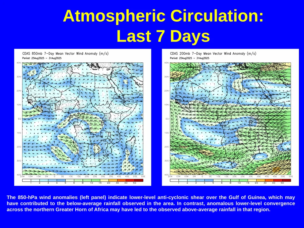
Last 7 Days The 850-hPa wind anomalies (left panel) indicate lower-level anti-cyclonic shear over the Gulf of Guinea, which may have contributed to the below-average rainfall observed in the area. In contrast, anomalous lower-level convergence across the northern Greater Horn of Africa may have led to the observed above-average rainfall in that region.<br>
08
NCEP GEFS Model Forecasts
Non-Bias Corrected Probability of
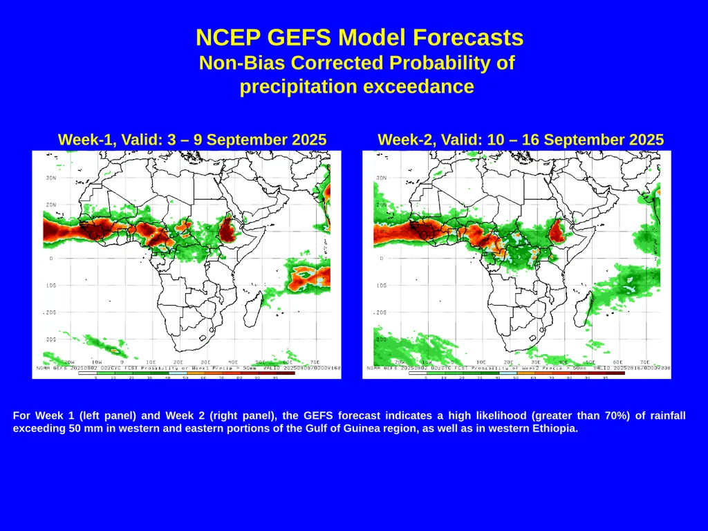
precipitation exceedance For Week 1 (left panel) and Week 2 (right panel), the GEFS forecast indicates a high likelihood (greater than 70%) of rainfall exceeding 50 mm in western and eastern portions of the Gulf of Guinea region, as well as in western Ethiopia. Week-1, Valid: 3 – 9 September 2025 Week-2, Valid: 10 – 16 September 2025<br>
09
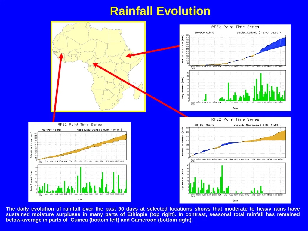
Rainfall Evolution The daily evolution of rainfall over the past 90 days at selected locations shows that moderate to heavy rains have sustained moisture surpluses in many parts of Ethiopia (top right). In contrast, seasonal total rainfall has remained below-average in parts of Guinea (bottom left) and Cameroon (bottom right).<br>
10
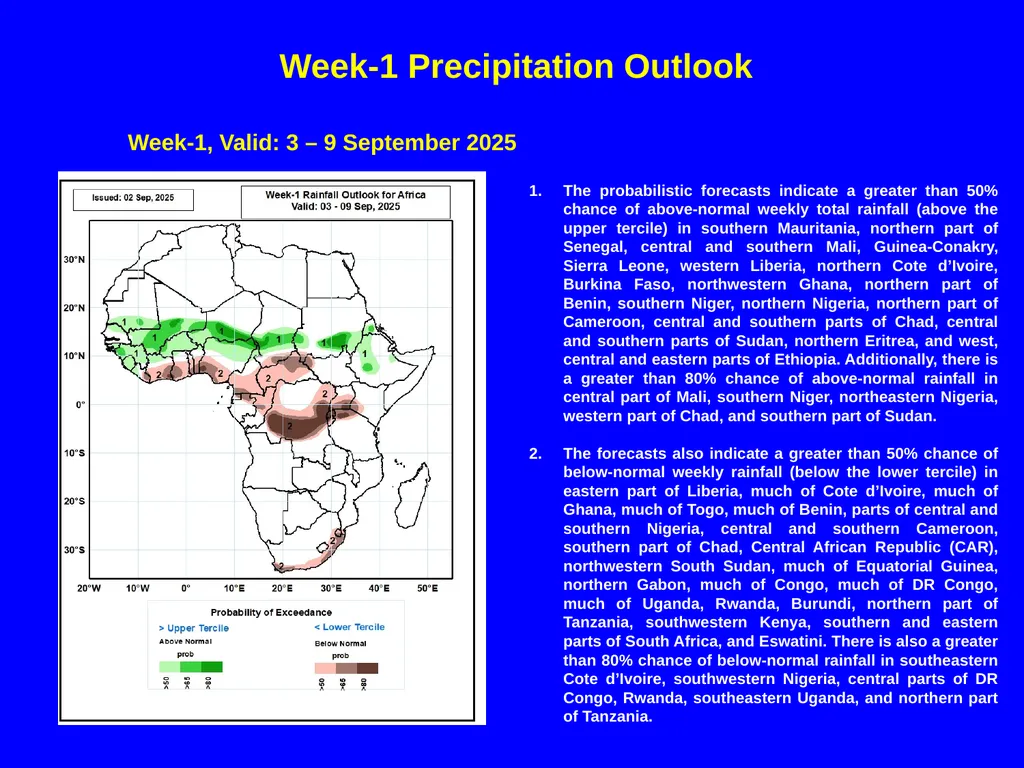
Week-1 Precipitation Outlook The probabilistic forecasts indicate a greater than 50% chance of above-normal weekly total rainfall (above the upper tercile) in southern Mauritania, northern part of Senegal, central and southern Mali, Guinea-Conakry, Sierra Leone, western Liberia, northern Cote d’Ivoire, Burkina Faso, northwestern Ghana, northern part of Benin, southern Niger, northern Nigeria, northern part of Cameroon, central and southern parts of Chad, central and southern parts of Sudan, northern Eritrea, and west, central and eastern parts of Ethiopia. Additionally, there is a greater than 80% chance of above-normal rainfall in central part of Mali, southern Niger, northeastern Nigeria, western part of Chad, and southern part of Sudan.
The forecasts also indicate a greater than 50% chance of below-normal weekly rainfall (below the lower tercile) in eastern part of Liberia, much of Cote d’Ivoire, much of Ghana, much of Togo, much of Benin, parts of central and southern Nigeria, central and southern Cameroon, southern part of Chad, Central African Republic (CAR), northwestern South Sudan, much of Equatorial Guinea, northern Gabon, much of Congo, much of DR Congo, much of Uganda, Rwanda, Burundi, northern part of Tanzania, southwestern Kenya, southern and eastern parts of South Africa, and Eswatini. There is also a greater than 80% chance of below-normal rainfall in southeastern Cote d’Ivoire, southwestern Nigeria, central parts of DR Congo, Rwanda, southeastern Uganda, and northern part of Tanzania. Week-1, Valid: 3 – 9 September 2025<br>
The forecasts also indicate a greater than 50% chance of below-normal weekly rainfall (below the lower tercile) in eastern part of Liberia, much of Cote d’Ivoire, much of Ghana, much of Togo, much of Benin, parts of central and southern Nigeria, central and southern Cameroon, southern part of Chad, Central African Republic (CAR), northwestern South Sudan, much of Equatorial Guinea, northern Gabon, much of Congo, much of DR Congo, much of Uganda, Rwanda, Burundi, northern part of Tanzania, southwestern Kenya, southern and eastern parts of South Africa, and Eswatini. There is also a greater than 80% chance of below-normal rainfall in southeastern Cote d’Ivoire, southwestern Nigeria, central parts of DR Congo, Rwanda, southeastern Uganda, and northern part of Tanzania. Week-1, Valid: 3 – 9 September 2025<br>
11
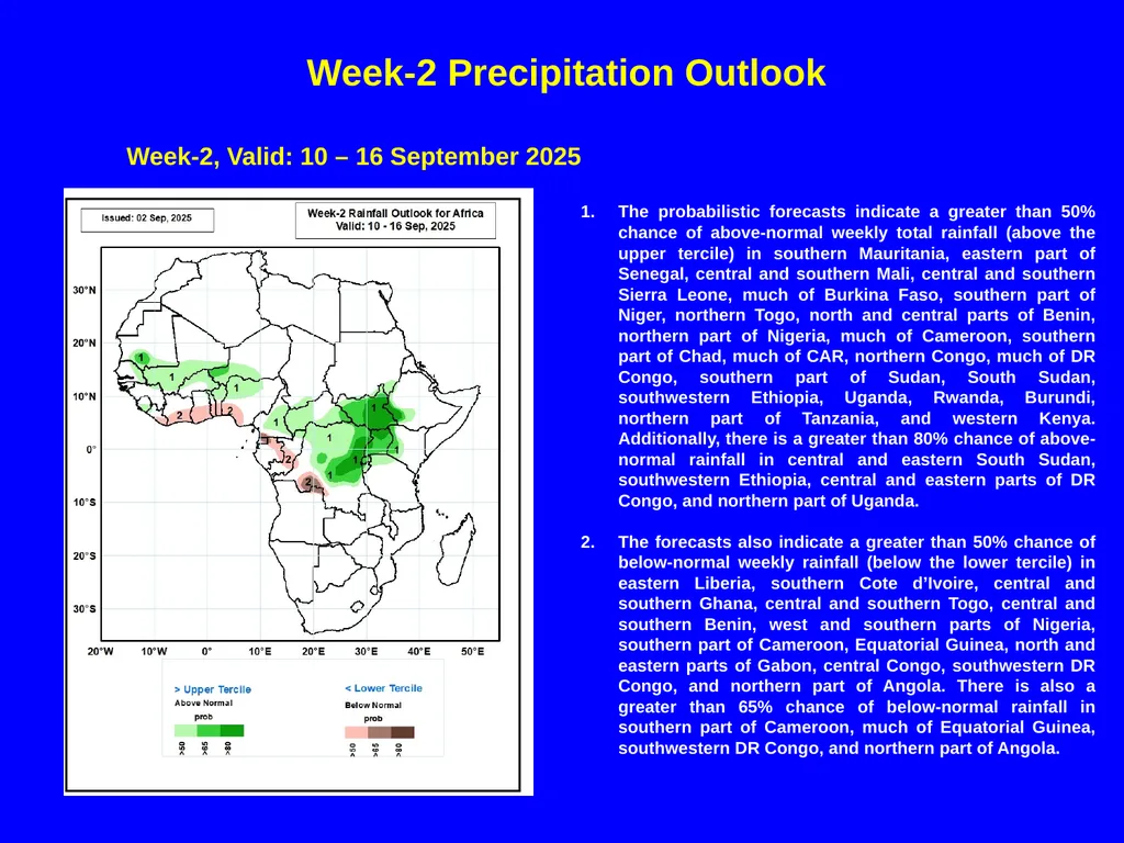
Week-2 Precipitation Outlook The probabilistic forecasts indicate a greater than 50% chance of above-normal weekly total rainfall (above the upper tercile) in southern Mauritania, eastern part of Senegal, central and southern Mali, central and southern Sierra Leone, much of Burkina Faso, southern part of Niger, northern Togo, north and central parts of Benin, northern part of Nigeria, much of Cameroon, southern part of Chad, much of CAR, northern Congo, much of DR Congo, southern part of Sudan, South Sudan, southwestern Ethiopia, Uganda, Rwanda, Burundi, northern part of Tanzania, and western Kenya. Additionally, there is a greater than 80% chance of above-normal rainfall in central and eastern South Sudan, southwestern Ethiopia, central and eastern parts of DR Congo, and northern part of Uganda.
The forecasts also indicate a greater than 50% chance of below-normal weekly rainfall (below the lower tercile) in eastern Liberia, southern Cote d’Ivoire, central and southern Ghana, central and southern Togo, central and southern Benin, west and southern parts of Nigeria, southern part of Cameroon, Equatorial Guinea, north and eastern parts of Gabon, central Congo, southwestern DR Congo, and northern part of Angola. There is also a greater than 65% chance of below-normal rainfall in southern part of Cameroon, much of Equatorial Guinea, southwestern DR Congo, and northern part of Angola. Week-2, Valid: 10 – 16 September 2025<br>
The forecasts also indicate a greater than 50% chance of below-normal weekly rainfall (below the lower tercile) in eastern Liberia, southern Cote d’Ivoire, central and southern Ghana, central and southern Togo, central and southern Benin, west and southern parts of Nigeria, southern part of Cameroon, Equatorial Guinea, north and eastern parts of Gabon, central Congo, southwestern DR Congo, and northern part of Angola. There is also a greater than 65% chance of below-normal rainfall in southern part of Cameroon, much of Equatorial Guinea, southwestern DR Congo, and northern part of Angola. Week-2, Valid: 10 – 16 September 2025<br>
12
Over the past 30 days in West Africa, above-average rainfall was observed in much of Senegal, adjacent southern Mauritania, Guinea-Bissau, eastern Mali, Burkina Faso, western and southern Niger, northern Benin, and pockets of northern Nigeria. In contrast, below-average rainfall was widespread across Guinea, Sierra Leone, Liberia, southeastern Mauritania, southern and western Mali, far western Burkina Faso, Côte d’Ivoire, large portions of Ghana, Togo, southern Benin, and central to southern Nigeria. The most notable deficits were concentrated across coastal Guinea through southern Mali and into Côte d’Ivoire and Ghana. In Central Africa, Below-average rainfall dominated much of Cameroon, western and southern Chad, large parts of the Central African Republic (CAR), Congo, and western to northeastern Democratic Republic of the Congo (DRC). In contrast, above-average rainfall was confined to parts of north-central DRC. In Eastern Africa, above-average rainfall occurred in southern and eastern Sudan, much of South Sudan, parts of Uganda, pockets of western Kenya, and large portions of Ethiopia’s Kiremt rainfall areas. Meanwhile, below-average rainfall was noted in pockets of southern Ethiopia. Strong positive anomalies extended from eastern Sudan into Eritrea and northern Ethiopia.
During the past seven days in West Africa, above-average rainfall was limited to far western Senegal, Guinea-Bissau, western Guinea, parts of Niger, and northeastern Nigeria. In contrast, widespread below-average rainfall was recorded across much of the Gulf of Guinea countries. Deficits were particularly pronounced across southern Mali, coastal Guinea, and central Nigeria. In Central Africa, above-average rainfall was confined to much of Chad and eastern Central African Republic (CAR). Meanwhile, below-average conditions dominated much of Cameroon, as well as parts of the Republic of the Congo and the Democratic Republic of the Congo (DRC). In Eastern Africa, above-average rainfall was recorded in southern and eastern Sudan, northern South Sudan, eastern and northern Ethiopia, and Eritrea. Below-average anomalies were limited to parts of southern South Sudan and western Ethiopia.
Week 1 forecasts indicate an increased likelihood of above-normal rainfall across many areas in the Sahel region, the far western Gulf of Guinea, southern Sudan, parts of Eritrea, and central Ethiopia. Conversely, there is an elevated chance of below-normal rainfall along the Gulf of Guinea coast, parts of Central Africa, and coastal South Africa.
Week 2 forecasts suggest an increased probability of above-normal rainfall across parts of the western Sahel region and many areas of Central Africa, extending into the Lake Victoria region. In contrast, below-normal rainfall is likely along the coastal areas of the Gulf of Guinea and the western portion of Central Africa. Summary<br>
During the past seven days in West Africa, above-average rainfall was limited to far western Senegal, Guinea-Bissau, western Guinea, parts of Niger, and northeastern Nigeria. In contrast, widespread below-average rainfall was recorded across much of the Gulf of Guinea countries. Deficits were particularly pronounced across southern Mali, coastal Guinea, and central Nigeria. In Central Africa, above-average rainfall was confined to much of Chad and eastern Central African Republic (CAR). Meanwhile, below-average conditions dominated much of Cameroon, as well as parts of the Republic of the Congo and the Democratic Republic of the Congo (DRC). In Eastern Africa, above-average rainfall was recorded in southern and eastern Sudan, northern South Sudan, eastern and northern Ethiopia, and Eritrea. Below-average anomalies were limited to parts of southern South Sudan and western Ethiopia.
Week 1 forecasts indicate an increased likelihood of above-normal rainfall across many areas in the Sahel region, the far western Gulf of Guinea, southern Sudan, parts of Eritrea, and central Ethiopia. Conversely, there is an elevated chance of below-normal rainfall along the Gulf of Guinea coast, parts of Central Africa, and coastal South Africa.
Week 2 forecasts suggest an increased probability of above-normal rainfall across parts of the western Sahel region and many areas of Central Africa, extending into the Lake Victoria region. In contrast, below-normal rainfall is likely along the coastal areas of the Gulf of Guinea and the western portion of Central Africa. Summary<br>