/
Landscape Landscape

Landscape - PDF document

ximena
ximena . @ximena
Follow
342 views
Uploaded On 2021-08-23

Landscape - PPT Presentation

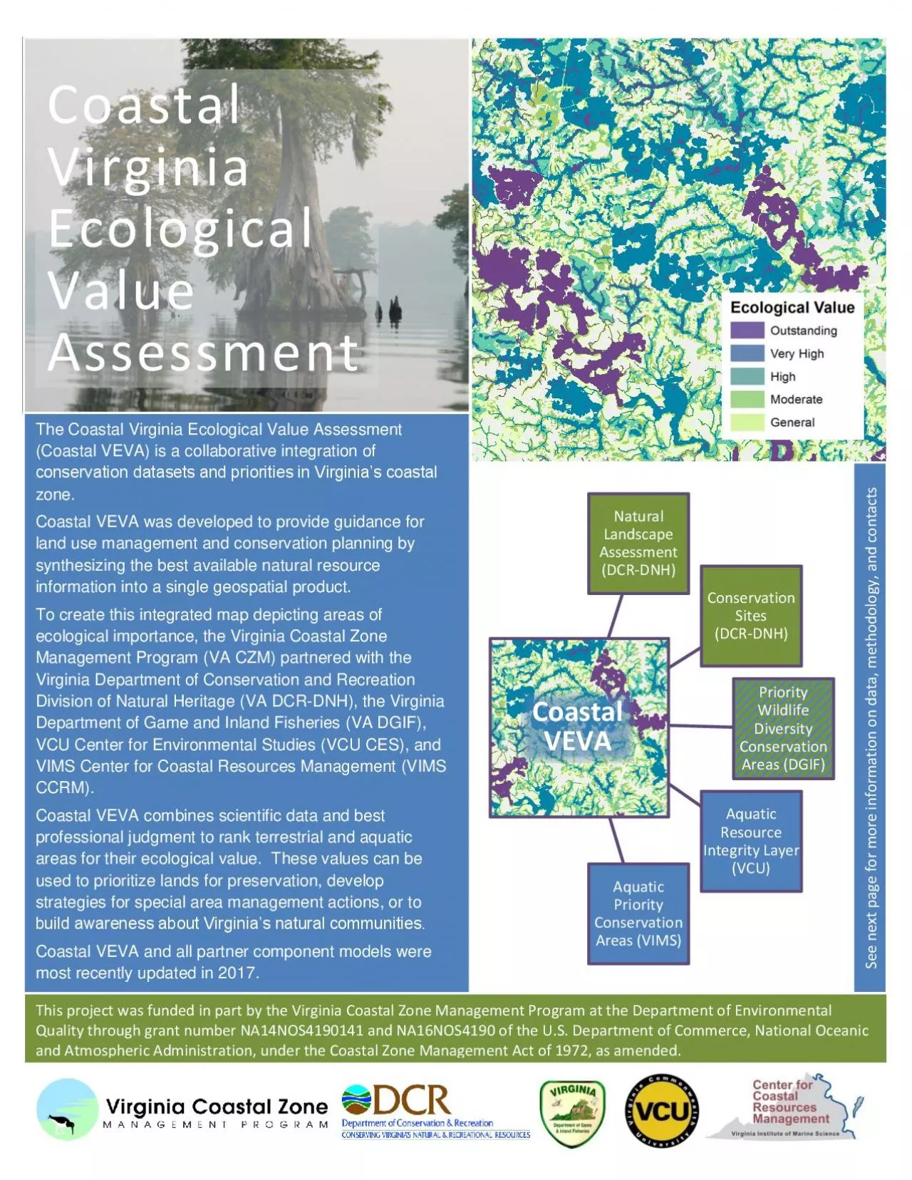
Natural Assessment DCRDNHConservation Sites DCRDNHPriority Wildlife Diversity Conservation Areas DGIFAquatic Resource Integrity Layer VCUAquatic Priority Conservation Areas VIMSCoastal Virgin ID: 870163

virginia coastal conservation veva coastal virginia veva conservation areas partner data management models vcu ecological dcr dgif department vims

Share:

Link:

Embed:

Download Presentation from below link

Download Pdf The PPT/PDF document "Landscape" is the property of its rightful owner. Permission is granted to download and print the materials on this web site for personal, non-commercial use only, and to display it on your personal computer provided you do not modify the materials and that you retain all copyright notices contained in the materials. By downloading content from our website, you accept the terms of this agreement.


Presentation Transcript

1 Natural Landscape Assessment (DCR - D
Natural Landscape Assessment (DCR - DNH) Conservation Sites (DCR - DNH) Priority Wildlife Diversity Conservation Areas (DGIF) Aquatic Resource Integrity Layer (VCU) Aquatic Priority Conservation Areas (VIMS) Coastal Virginia Ecological Assessment The Coastal Virginia Ecological Value Assessment (Coastal VEVA) is a collaborative integration of conservation datasets and priorities in Virginia’s coastal zone. Coastal VEVA was developed to provide guidance for land use management and conservation planning by information into a single geospatial product. To create this integrated map depicting areas of ecological importance, the Virginia Coastal Zone Management Program (VA CZM) partnered with the Virginia Department of Conservation and Recreation Division of Natural Heritage ( DCR - DNH) , the Virginia Department of Game and Inland Fisheries ( VA DGIF) , VCU Center for Environmental Studies (VCU CES) , and VI (VIMS CCRM) . Coastal VEVA combines scientific data and best professional judgment to rank terrestrial and aquatic areas for their ecological value. These values can be used to prioritize lands for preservation, develop str ategies for special area management actions, or to Coastal VEVA and all partner component models were most recently updated in 2017 . Coastal VEVA This project was funded in part by the Virginia Coastal Zone Management Program at the Department of Environmental Qual

2 ity through grant number NA14NOS4190141
ity through grant number NA14NOS4190141 and NA16NOS4190 of the U.S. Department of Commerce, National Oceanic and Atmospheric Administration, under the Coastal Zone Management Act of 1972, as amended. See next page for more information on data, methodology, and contacts Coastal VEVA was created by overlaying areas of ecological importance as defined and created by identified partner experts. Each partner provided models which assigned values of significance to areas based on expert opinion. Partner Component Models and Input Data Coastal VEVA is intended to guide conservation planning and efforts, and is not intended to replace on the ground surveys or consultation with biologists. This data serves as a compliment to existin g local data . The final layer was created by overlaying all the models and picking out the highest value at each location (called a max value). The highest value was then used to create the final layer. Coastal VEVA can be found under the Conservation Planning category on Virginia CZM ’s Coastal GEMS mapping application at www.coastalgems.org For more information contact: Coastal VEVA : VA CZM Program , Nicholas Meade nick.meade@deq.virginia.gov Partner Compone nt Models: VA DCR - DNH, Joseph Weber joseph.weber@dcr.virginia.gov VA DGIF, Jay Kapalczynski Jay.Kapalczynski@dgif.virginia.gov VCU CES, Will Shuart wshuart@vcu.edu VIMS CCRM, Marcia Berman marcia@vims.ed