/
Robots lend themselves well to mapmaking. Any place not ope Robots lend themselves well to mapmaking. Any place not ope

Robots lend themselves well to mapmaking. Any place not ope - PowerPoint Presentation

yoshiko-marsland
yoshiko-marsland . @yoshiko-marsland
Follow
377 views
Uploaded On 2017-08-24

Robots lend themselves well to mapmaking. Any place not ope - PPT Presentation

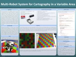
humans This research was conducted in order to develop a method of mapping carried out primarily by Lego Mindstorms EV3 robots The robots were made to use leJOS allowing them to run Java programs An algorithm was developed that would make a robot traverse an area scanning the terrain at a freq ID: 581862

robots mapping area map mapping robots map area robot research mapped maps ev3 situations retrieved data multi http humans

Share:

Link:

Embed:

Download Presentation from below link

Download Presentation The PPT/PDF document "Robots lend themselves well to mapmaking..." is the property of its rightful owner. Permission is granted to download and print the materials on this web site for personal, non-commercial use only, and to display it on your personal computer provided you do not modify the materials and that you retain all copyright notices contained in the materials. By downloading content from our website, you accept the terms of this agreement.


Presentation Transcript

Slide1

Robots lend themselves well to mapmaking. Any place not open to aerial observation that is also hazardous to humans is best explored by expendable robots. They could reveal the layout of a building, including potential threats. This would be a huge help for first responders in a variety of situations from toxic spills to hostage situations. There are also natural spaces that have yet to be mapped. Caves and the deep ocean in particular have great scientific value but can pose a danger to humans. This research was conducted in order to develop a method of mapping carried out primarily by Lego Mindstorms EV3 robots. The robots were made to use leJOS, allowing them to run Java programs. An algorithm was developed that would make a robot traverse an area, scanning the terrain at a frequency chosen by the user, allowing a balance of speed and precision. One robot can map a flat area of user-given dimensions with satisfactory precision. When additional robots are added, the mapping process is much faster. Based on the number of robots, the area is divided into smaller sections which are then scanned by individual robots. This research shows that robotic mapping systems are viable.

ABSTRACT

BACKGROUND

4 LEGO Mindstorms EV3s running leJOS 0.8.1 – beta4 micro SD cards4 NetGear WNA1100 Wi-Fi dongles1 laptop running jGRASP and Eclipse with the leJOS EV3 plugin

MATERIALS

The maps produced varied in accuracy. Interestingly enough, they were more accurate at lower resolutions. This is due to the fact that the robots will veer to the right or left over time. The less time they have to do this, the less error it will cause. More detailed maps are created by having the robot move a shorter distance between each reading, so it makes sense that these maps would be more accurate. Turning is also a problem for the robots. When told to rotate 90 degrees, some robots move more than 90 degrees and some move fewer than 90 degrees. This means that an EV3 cannot perfectly carry out the instructions it is given. The most difficult aspect of this research was the hardware and the inaccuracies this caused in the maps. Future robotic mapping systems will need to rely on better hardware than LEGO Mindstorms EV3s.

ANALYSIS

CONCLUSION

This research has demonstrated the viability of multi-robot systems for mapping unknown areas of user-defined size. This could be an excellent tool for mapping dangerous areas.

FUTURE RESEARCH

Mapping from the air or underwaterThree-dimensional mappingLocating certain terrain features or objectsHardware that can better carry out the task of mapping

REFERENCES

Dirafzoon, A., Lobaton, E. (n.d.) Topological Mapping of Unknown Environments using an Unlocalized Robotic Swarm. Retrieved from https://research.ece.ncsu.edu/aros/wp-content/uploads/2013/10/IROS2013_SwarmEst.pdfKo, J., Stewart, B., Fox, D., Konolige, K., Limketkai, B. (2003). A Practical, Decision-theoretic Approach to Multi-robot Mapping and Exploration. Retrieved from http://mobilerobotics.cs.washington.edu/projects/exploration/postscripts/multi-exploration-iros-03.pdfPrasad, J. (2008, November) Amorphous Computing and Swarm Intelligence. Retrieved from http://dspace.cusat.ac.in/jspui/bitstream/123456789/1186/1/Amorphous%20computing%20and%20swarm%20intelligence.pdfŞahin, E. (2005, January) Swarm Robotics: From Sources of Inspiration to Domains of Application. Retrieved from http://www.kovan.ceng.metu.edu.tr/pub/pdf/METU-CENG-TR-2005-01.pdfThrun, S., Burgard, W., Fox, D. (April 2000). A Real-Time Algorithm for Mobile Robot Mapping With Applications to Multi-Robot and 3D Mapping. Retrieved from http://www.eng.auburn.edu/~troppel/courses/00sum13/7970%202013A%20ADvMobRob%20sp13/literature/3D%20mapping%20thrun%20ICRA%202000.pdf

Mapping has many implications for scientific research and public safety. While satellite imaging or aerial observation are usually sufficient to make a map, sometimes it is not possible to map from the air. This can be because the locale to be mapped is indoors, underground, or underwater. In these situations, it is necessary that the location must be entered in order to be mapped. However, the situation in which maps are needed most urgently, the areas can be extremely dangerous to humans. Police may need to know the layout of a building to deal with violent criminals or scientists may want to know what lies at the bottom of an ocean trench. In these situations, mapping is best done by nonhuman, expendable agents.

Multi-Robot System for Cartography in a Variable Area

SAMPLE CODE

GOAL

A mapping system that removes humans from dangerous situations would be beneficial to first responders and scientists. To that end, a system that enables simple robots to map an area will be developed.

METHODS AND PROCEDURES

Install leJOS 0.8.1 – beta onto each EV3Configure Wi-Fi on each EV3Develop an algorithm to efficiently traverse an area of an unknown sizeProgram one EV3 to map the area it traversesHave the EV3 write the map data to a fileWrite a program that uses the data to draw a mapDevelop a way to efficiently split an area into four parts and have it traversed by four robotsProgram the robots to split up an area and map itWrite a program that aggregates the data from all four robotsDevelop a way to use the data to draw a map

This is one of the EV3s used for mapping

.

These pictures show the difficulties the EV3s have when mapping. The area that was mapped is shown on the right. Every square not covered in duct tape was supposed to have been mapped. The resulting map is shown on the left.

This is part of one of the algorithms that moves the robot and scans the terrain to receive map data.