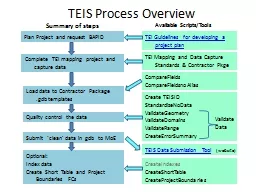
StandardizeNoData ValidateGeometry ValidateDomains ValidateRange CreateErrorSummary Load data to Contractor Package gdb templates Quality control the data Submit clean data in gdb ID: 933466
Download Presentation The PPT/PDF document "TEIS Process Overview Create TEISID" is the property of its rightful owner. Permission is granted to download and print the materials on this web site for personal, non-commercial use only, and to display it on your personal computer provided you do not modify the materials and that you retain all copyright notices contained in the materials. By downloading content from our website, you accept the terms of this agreement.
Slide1
TEIS Process Overview
Create TEISIDStandardizeNoDataValidateGeometryValidateDomainsValidateRangeCreateErrorSummary
Load data to Contractor Package .gdb templates
Quality control the data
Submit ‘clean’ data in gdb to MoE
Optional: Index dataCreate Short Table and Project Boundaries FCs
Summary of steps
Available Scripts/Tools
TEIS Data Submission Tool (website)
CreateIndexesCreateShortTableCreateProjectBoundaries
CompareFieldsCompareFieldsnoAlias
Plan Project and request BAPID
Complete TEI mapping
project and capture data
TEI Guidelines for developing a project plan
TEI Mapping and Data Capture Standards & Contractor
Pkge
Validate
Data
Slide2Loading new data to the .
gdbCapture spatial data using your ‘usual’ tools and procedures
StepsPython Scripts/Tools
Populate a polygon attribute table using your ‘usual’ tools and procedures (e.g. Excel)
Populate a project details table using your ‘usual’ tools (e.g. Excel)
Load all the above to the Long Table and Project Details templates in the .gdb
Long Table FC
Project
Details Table
Go to QC steps
TEIS Contractor Package contains:
Long Table Template Project Details Template in the Operational.gdb
Slide3To import an existing coverage to the .
gdb:Go to QC steps
Import coverage to a blank .gdb
Set tolerance to 0.001
CompareFields or CompareFieldsnoAlias
StandardizeNoData (also run later with QA tools)
StepsPython Scripts/Tools
Compare the imported fields to the current TEIS templates
Fix Fields as necessary (e.g. create new fields to match Template Field name, data type, field length, etc. and recalculate values)
Fix fields that should be blank (no data) but contain ‘0’ zeros
Data is now in the TEIS standard .
gdb
Slide4TEIS Quality Control Procedures:
StepsPython Scripts/Tools
Create a unique identifier for each Long Table record
Check Geometry (of Long Table)
Check for valid attributes (codes)
Using the TEIS_ID (= Feature ID in error reports)Link the error reports and/or error summary table to Long Table, and work through fixing the invalid codes, etc.
CreateTEISIDStandardizeNoData
ValidateGeometry
ValidateDomains
ValidateRows CreateErrorSummary
Submit .gdb to MoE and/or do additional (optional) processing
TEIS Data Submission Website
Create a unique identifier for each Long Table record
Check Geometry (of Long Table)
Check for valid attributes (codes) (check domains and ranges)
Create a summary of errors for each record in Long Table
Error Checking
Repeat this QC procedure until data is clean.
ValidateData
Slide5Additional (optional) steps
Note: If amalgamating multiple project datasets into one set of feature classes, re-create unique TEIS_ID’s first, then index the data and rerun QC routines and optional routines Note: CreateProjectBoundary
requires an ArcInfo Licence level to run.Steps
Python Scripts/Tools
Summarize Long Table data to create label fields and pull out key attributes (e.g. for plotting or manual/visual review)
Create a project boundary FC with project details
Index the data (v. large datasets)
CreateIndexes
CreateShortTable
CreateProjectBoundary
Optional steps