/
USING DISTANCE DIAGRAMS and MILEAGE CHARTS USING DISTANCE DIAGRAMS and MILEAGE CHARTS

USING DISTANCE DIAGRAMS and MILEAGE CHARTS - PowerPoint Presentation

ash
ash . @ash
Follow
73 views
Uploaded On 2023-10-04

USING DISTANCE DIAGRAMS and MILEAGE CHARTS - PPT Presentation

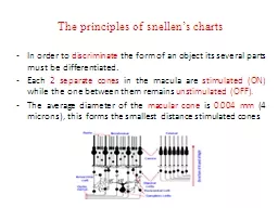
Functional Mathematics Curriculum links E3 Understand estimate measure amp compare length capacity weight temperature Complete simple calculations involving money and measures Extract use and compare information from lists tables simple chartsgraphs ID: 1022954

exeter plymouth mileage barnstaple plymouth exeter barnstaple mileage travel finally altogether travels jerry solution miles distance charts complete diagrams

Share:

Link:

Embed:

Download Presentation from below link

Download Presentation The PPT/PDF document "USING DISTANCE DIAGRAMS and MILEAGE CHAR..." is the property of its rightful owner. Permission is granted to download and print the materials on this web site for personal, non-commercial use only, and to display it on your personal computer provided you do not modify the materials and that you retain all copyright notices contained in the materials. By downloading content from our website, you accept the terms of this agreement.


Presentation Transcript

1. USING DISTANCE DIAGRAMS and MILEAGE CHARTSFunctional Mathematics Curriculum linksE3: Understand, estimate, measure & compare length, capacity, weight, temperature. Complete simple calculations involving money and measures. Extract, use and compare information from lists, tables, simple charts/graphsL1: Solve problems requiring calculation, with common measures, inc. money, time, length, weight, capacity and temperature. Extract and interpret information from tables, diagrams, charts and graphs. September 2017. Kindly contributed by Nicola Smith, Gloucestershire College. Search for Nicky on www.skillsworkshop.org Please refer to the download page for this resource on skillsworkshop for detailed curriculum links and related resources.Ensure that you run this PPT as a full screen slideshow or you will miss the useful animated help and pop up solutions.

2. Aim: To recognise and use a mileage chartObjectives: * To calculate the distance between various places using a mileage chart.* Design and complete a chart to display mileage between different places.Mileage Charts

3. Mileage ChartDistances in the table below are given in miles.How do we use it?

4. (a) How far is it from Bristol to Plymouth?

5. (a) 125 miles(a) How far is it from Bristol to Plymouth?OK! Nice easy one to start with.Solution

6. How far is it from Barnstable to Plymouth?

7. (b) Jerry travels from Barnstaple to Exeter, then from Exeter to Plymouth, and finally from Plymouth back to Barnstaple.How far does he travel altogether?Don't shout out the answer. Let everyone have a go.Write it down and then we will see if you are right.

8. Solution(b) Jerry travels from Barnstaple to Exeter, then from Exeter to Plymouth, and finally from Plymouth back to Barnstaple.How far does he travel altogether?55

9. Solution(b) Jerry travels from Barnstaple to Exeter, then from Exeter to Plymouth, and finally from Plymouth back to Barnstaple.How far does he travel altogether?+4455

10. Solution(b) Jerry travels from Barnstaple to Exeter, then from Exeter to Plymouth, and finally from Plymouth back to Barnstaple.How far does he travel altogether?+4455+67=166

11. DISTANCE DIAGRAMS

12. Copy the empty mileage chart and complete it. Remember to use the shortest distance between the towns. E.g. For Devizes to Amesbury use 19 miles not 20.

13. 19825614119101715How do we do each one?

14. CHALLENGE QUESTIONYou have to deliver the post to the following towns. Start at Carmarthen. Go to Llandovery, then on to Lampeter and then on to Llanwrda. From Llanwrda you go to Llandeilo and then back to Carmarthan. How many miles will you travel?