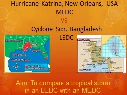
/
SARASOTA COUNTY – LIDO KEY HURRICANE & STORM DAMAGE REDUCTION PROJECT SARASOTA COUNTY – LIDO KEY HURRICANE & STORM DAMAGE REDUCTION PROJECT

SARASOTA COUNTY – LIDO KEY HURRICANE & STORM DAMAGE REDUCTION PROJECT - PowerPoint Presentation

billiontins
billiontins . @billiontins
Follow
346 views
Uploaded On 2020-07-01

SARASOTA COUNTY – LIDO KEY HURRICANE & STORM DAMAGE REDUCTION PROJECT - PPT Presentation

City of Sarasota Sarasota County US Army Corps of Engineers 22 October 2013 Sarasota Florida Presented by Milan A Mora PE Jason Engle PE James LaGrone Kathleen McConnell ID: 791755

groins key jacksonville army key groins army jacksonville corps project engineers building nourishment district shoal ebb bsp lido beach

Share:

Link:

Embed:

Download Presentation from below link

Download The PPT/PDF document "SARASOTA COUNTY – LIDO KEY HURRICANE &..." is the property of its rightful owner. Permission is granted to download and print the materials on this web site for personal, non-commercial use only, and to display it on your personal computer provided you do not modify the materials and that you retain all copyright notices contained in the materials. By downloading content from our website, you accept the terms of this agreement.


Presentation Transcript

Slide1

SARASOTA COUNTY – LIDO KEY HURRICANE & STORM DAMAGE REDUCTION PROJECT

City of SarasotaSarasota CountyUS Army Corps of Engineers22 October 2013Sarasota, FloridaPresented by: Milan A. Mora, P.E. Jason Engle, P.E. James LaGrone Kathleen McConnell

BUILDING STRONG

®

US ARMY CORPS OF ENGINEERS | JACKSONVILLE DISTRICT

Information Presentation

BOCC Joint Meeting

Slide2

OVERVIEW – PROJECT SCOPE

Authorized WRDA 1999 Authority was contingent on a feasibility assessment of the project.2002 Feasibility Study with Environmental Assessment (amended April 2004) determined that project was technically sound, environmentally acceptable and economically justified.

BUILDING STRONG

®

US ARMY CORPS OF ENGINEERS | Jacksonville District

2

1971

2006

1986

Slide3

OVERVIEW – PROJECT FEATURES

BUILDING STRONG®US ARMY CORPS OF ENGINEERS | Jacksonville District

3

80 ft Design

Berm

over 1.6 miles

D2

C

B

3 Proposed Sand Sources

Groin Field

(

3)

Project Scope

Project Length (ft) = 8,280 (R-35 to R43)

Design

berm

elevation (ft) = +5 NGVD

Approximately 460,000 cy of design and 615,000 cy

of advance material (1,075,000 cy for Initial Const)

Three groins along the southern portion

Borrow Areas: Big Sarasota Pass (BSP) & New Pass

5-year nourishment interval over 50-year life

615,000 cy required for each re-nourishment

Slide4

PROJECT PLAN

BUILDING STRONG®US ARMY CORPS OF ENGINEERS | Jacksonville District

4

1)

Placement:

Place approximately 1.1M CY of sand on Lido Key

2) Source:

Obtain

Sediment for Nourishment of Lido Key

Egmont Key (Tampa Bay)

Offshore of Longboat Key

Ebb Shoal at Big Sarasota Pass (BSP)

New Pass – Future

3) Retain

:

Construct Three (3) groins at the south end of Lido Key

Slide5

PLACEMENT – LIDO KEY

BUILDING STRONG®

US ARMY CORPS OF ENGINEERS | Jacksonville District

5

MHW Line - Design

Berm

2013 MHW Line

MHW Line - Advanced

Berm

FDEP Monument R-39

(Lime Tree Resort/Condos)

150’

150’

80’ Design

Berm

@ 5’

Advanced

Berm

Slide6

SOURCE – BSP BORROW AREAS

BUILDING STRONG®US ARMY CORPS OF ENGINEERS | Jacksonville District

6

D2

C

B

Slide7

RETAIN – SOUTHERN GROINS

BUILDING STRONG®US ARMY CORPS OF ENGINEERS | Jacksonville District

7

Retain

Beach Nourishment

Slide8

BUILDING STRONG

®US ARMY CORPS OF ENGINEERS | Jacksonville District

PROJECT PLAN –

BORROW AREA QUESTIONS?

Slide9

BORROW AREAS?

What are the proposed borrow area footprints?

How will this affect Big

Sarasota Pass morphology?

How will this affect Siesta Key?

What

are

the effects

on the navigation channel?

Slide10

alt d2, C, B – 1.7

mcY

BORROW

AREA FOOTPRINTS

D2

C

B

Slide11

Flood Marginal Channel

Relic ChannelUpdrift ShoalMain Ebb Channel

Distal Lobe

Downdrift

AttachmentFlood Marginal Channel

In the long term:

These areas will be deeper

BSP MORPHOLOGY

Existing Conditions

Slide12

% Increase in wave energy here and here

% Decrease in wave energy here and here

Results from the CMS morphologic model yields No indication of increased erosion over the Existing Condition at Siesta Key

HOW WILL THIS AFFECT SIESTA KEY?

Slide13

Navigable water greater than 6m depth

without projectNavigable water greater than 6m depth with projectNo significant difference in navigable water depths without and with project

EFFECT ON CURRENT

NAVIGATION?

Slide14

BUILDING STRONG

®US ARMY CORPS OF ENGINEERS | Jacksonville DistrictPROJECT PLAN –

SOUTHERN GROINS

GENERAL

QUESTIONS?

Slide15

SOUTH LIDO KEY GROINS

What are the plans for the groins?How long are they?How much space is between them?How big are they?

Can

I walk along the beach?

Can I swim in the surf zone?Can I navigate past them?

Slide16

350’

500’460’

600’

800’

2004

Present Day

HOW LONG? HOW MUCH SPACE IN BETWEEN ?

Slide17

HOW BIG ARE THEY?

Slide18

CAN I WALK ALONG THE BEACH?

Slide19

CAN I SWIM IN THE SURF ZONE?

CAN I NAVIGATE PAST THEM?

Slide20

BUILDING STRONG

®US ARMY CORPS OF ENGINEERS | Jacksonville DistrictPROJECT PLAN –

SOUTHERN GROINS

HYPOTHETICAL

QUESTIONS?

Slide21

What if the groins do not work?

What is the effect on Lido Beach?What is the effect on Siesta Key?How will the groins affect the ebb shoal in BSP?Why nourish the beach if we are installing structures?

Slide22

Downdrift Effects

Sediment Bypassing to BSP Ebb Shoal

Groins are constructed to anchor the nourishment template – not to intercept

Sediment at the expense of downdrift beaches or ebb shoal morphology!

WHAT IS THE EFFECT ON LIDO KEY?

WHAT IS THE EFFECT ON SIESTA KEY?

Slide23

How will the groins affect the ebb shoal in BSP?

Downdrift Effects

Sediment Bypassing to BSP Ebb Shoal

Adequate sediment bypassing at the seaward end of the groin structures will deter the growth of a

crescentic

shoreline . Adequate bypassing to the Ebb Shoal ensures that BSP will maintain its morphology – seen by lack of erosion in the shoal itself

Slide24

Why nourish the beach if we are installing structures?

Groins are constructed to anchor the nourishment template – not to intercept sediment at the expense of downdrift beaches or ebb shoal morphology!Groin construction without an associated nourishment project can lead to downdrift erosion and a lack of sediment supply to downdrift systemsThe groins are designed to work with the nourishment design template – should the beach erode shoreward of the design template, Emergency measures are implemented

Slide25

Groins – Anchor the Nourishment

Beach Nourishment

Retain

1981

1983

1986

Slide26

BUILDING STRONG

®US ARMY CORPS OF ENGINEERS | Jacksonville District

Questions/Discussions

Milan A. Mora, P.E.Project ManagerJacksonville DistrictWater Resources Branch701 San Marco Boulevard

Jacksonville, FL 32207

904-232-1454

millan.a.mora@usace.army.mil

LIDO KEY SPP