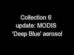
Andrew M Sayer N Christina Hsu Corey Bettenhausen MyeongJae Jeong Jaehwa Lee MODIS Red Green Blue composite MODIS Dark Target AOD 0 05 10 15 20 MODIS Deep Blue AOD ID: 737777
Download Presentation The PPT/PDF document "Collection 6 update: MODIS ‘Deep Blueâ..." is the property of its rightful owner. Permission is granted to download and print the materials on this web site for personal, non-commercial use only, and to display it on your personal computer provided you do not modify the materials and that you retain all copyright notices contained in the materials. By downloading content from our website, you accept the terms of this agreement.
Slide1
Collection 6 update:MODIS ‘Deep Blue’ aerosol
Andrew M. Sayer, N. Christina Hsu, Corey Bettenhausen, Myeong-Jae Jeong, Jaehwa LeeSlide2
MODIS
Red
-
Green
-
Blue
composite
MODIS
Dark
Target
AOD
0
0.5
1.0
1.5
2.0
MODIS
Deep
Blue AOD
0
0.5
1.0
1.5
2.0
Dust storm: 6
th
April 2001Slide3
Some applications of Deep Blue data… (1)
Global dust source mappingGinoux et al. (2012) Global-scale attribution of anthropogenic and natural dust sources and their emission rates based on MODIS Deep Blue aerosol products, Rev. Geophys., 50, RG3005, doi:10.1029/2012RG000388.Slide4
Some applications of Deep Blue data… (2)
Comparison of aerosol optical depth from multiple satellite datasets during an intense Saharan dust storm in March 2006
Carboni et al. (2012), Intercomparison of desert dust optical depth from satellite measurements, Atmos. Meas. Tech., 5, 1973-2002, doi:10.5194/amt-5-1973-2012.Slide5
Some applications of Deep Blue data… (3)
Combination with Dark Target aerosol data to compare aerosol/cloud/precipitation relationships between models and satellite observationsYi et al. (2012), Aerosol-cloud-precipitation relationships from satellite observations and global climate model simulations, J. Appl
. Remote Sens. 6(1), 063503, doi:10.1117/1.JRS.6.063503Slide6
Some applications of Deep Blue data… (4)
Constraints on mineral dust aerosol emission in the Gobi and Taklamakan deserts through combination with MISR data and the Geos-Chem modelWang et al. (2012), Top-down estimate of dust emissions through integration of MODIS and MISR aerosol retrievals with the GEOS-
Chem adjoint model, Geophys. Res.
Lett., 39, L08802, doi:10.1029/2012GL051136Slide7
Main developments
Collection 6 will include various refinements to Deep Blue:Extended coverage to vegetated surfaces, as well as bright land.Improved surface reflectance models.
Improved aerosol microphysical modelsImproved cloud screeningSimplified quality assurance (QA) flags
Calibration improvements will mean that Deep Blue can be applied to the whole MODIS recordMerged Deep Blue – Dark Target aerosol SDS, to provide a dataset with fewer gaps, for
visualisation purposesSlide8
Extended spatial coverageSlide9
Cloud screening
In Collection 5, some cloud-free areas were flagged as cloudy by the 1.38 micron (cirrus/high cloud) testCombination of high surface reflectance, aerosol, and low columnar water vaporDeveloped several tests to reduce these false negatives: typically gives more high-AOD eventsFalse positives also decreased through refinement of other cloud tests and QA flags
01/07/2003
Before
AfterSlide10
RR1.38/0.66
AOT C5.1
AOT C6
CALIOP TAB, 532 nm
Thin
Cirrus Under-Screening
over
Southeast
Asia, February 18
th 2002Converse of previous case: undetected cirrus, visible in CALIOP, led to contamination (high biases) in C5.1 retrievalNew reflectance ratio and tests identify this, removing the retrievals from Collection 6
Not found to introduce significant false negativesSee poster here by Jaehwa Lee et alSlide11
Merged dataset
C6 will include a new SDS of merged 550 nm AOD from the Deep Blue and Dark Target algorithms.To minimize pixel-level discontinuities and for simplicity/clarity, pixels will be assigned to either algorithm based on climatology of atmospherically corrected NDVIOnly Deep Blue is available for bright barren surfacesDark Target has longer heritage for vegetated surfaces
Note SDS will also include the ocean algorithm retrievalsWill be an interim ‘transition zone’ where retrievals will either be averaged (if the same QA) or that with higher QA flag chosenExample shown to the right for June
Dark Target
Deep Blue
Merging zone
Multiannual mean NDVI, JuneSlide12
Validation
Validated Aqua data against AERONETSee also poster by A. M. Sayer et al., and a paper has been submitted to JGROne-sigma absolute uncertainty estimates provided for each pixel, dependent on viewing geometry and AODFor typical geometries, expected error (EE) approximately 0.03+20%
Similar at other wavelengths (412 nm, 470 nm, 670 nm)Slide13
Correlations are high: capture variability at individual sites wellMost sites have 68% or more of matchups within expected error, and small biases
Performance poorer for spatially heterogeneous sites, and complex aerosol mixtures (typically parts of Africa and SE Asia)Slide14
Comparison to C5
Have validated C5 and C6 against AERONET for 10 sites where both perform retrievalsC6 has a better data volume (~ double the number of matchups), better correlation with AERONET (0.93 vs. 0.86), and smaller errors on retrieved AOD (bias ~halved, RMS error decrease by ~30%)Slide15
Effect of L1b changes
Ran C6 algorithm through C5 and C6 L1bs for long-term AERONET sites, to evaluate effect of radiometric calibration changeNote 2002 and 2011/2012 are incomplete due to Aqua and AERONET respectivelyDifferences become stronger in later yearsC6 L1bs result in better retrievalsEffect is smaller than that of algorithmic improvements
Small trend in biases in retrievals for both calibration coefficientsUnknown whether this is coincidental, algorithmic, or calibration-relatedThank you MCST!Slide16
Summary
Quality:The C6 Deep Blue dataset will have better spatial coverage (including vegetated land surfaces) and smaller uncertainties than C5We will be providing uncertainty estimates on an individual-retrieval basis, to aid quantitative analysis and facilitate applications such as data assimilationStatus:
Aqua is ready to goTerra testing is underway; the delay is due to the extra calibration efforts required for TerraAlgorithm and validation papers have been preparedThanks to MCST and the Ocean
Colour group for their extensive efforts in maintaining the high radiometric quality of MODIS data, and to the AERONET PIs for creation and stewardship of this invaluable resource for validation