/
Mid-Atlantic Blue Ocean Economy 2030 Mid-Atlantic Blue Ocean Economy 2030

Mid-Atlantic Blue Ocean Economy 2030 - PowerPoint Presentation

byrne
byrne . @byrne
Follow
28 views
Uploaded On 2024-02-03

Mid-Atlantic Blue Ocean Economy 2030 - PPT Presentation

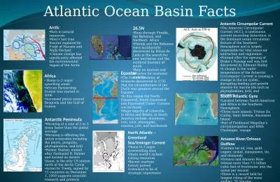
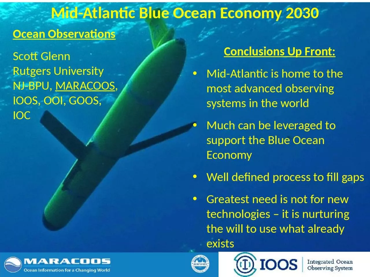
Conclusions Up Front MidAtlantic is home to the most advanced observing systems in the world Much can be leveraged to support the Blue Ocean Economy Well defined process to fill gaps Greatest need is not for new technologies ID: 1044265

forecast amp ocean currents amp forecast currents ocean analysis atlantic input uscg spill bacteria floatables dataset mid saropsoperational plumes

Share:

Link:

Embed:

Download Presentation from below link

Download Presentation The PPT/PDF document "Mid-Atlantic Blue Ocean Economy 2030" is the property of its rightful owner. Permission is granted to download and print the materials on this web site for personal, non-commercial use only, and to display it on your personal computer provided you do not modify the materials and that you retain all copyright notices contained in the materials. By downloading content from our website, you accept the terms of this agreement.


Presentation Transcript

1. Mid-Atlantic Blue Ocean Economy 2030Conclusions Up Front:Mid-Atlantic is home to the most advanced observing systems in the worldMuch can be leveraged to support the Blue Ocean EconomyWell defined process to fill gapsGreatest need is not for new technologies – it is nurturing the will to use what already existsOcean ObservationsScott GlennRutgers UniversityNJ-BPU, MARACOOS, IOOS, OOI, GOOS, IOC

2. Mid-Atlantic Drivers1/4 of U.S. Population1/4 of U.S. GDPWorld’s Largest Navy PortCommercial PortsFishing FleetsEnergy - Offshore Wind…..Mid-Atlantic StressorsWater qualityHurricanes & Winter StormsFlooding – Extreme and NuisanceHypoxiaIntense multi-use waterwaysUrbanized coasts….

3. Mid-Atlantic Bight is Physically Complex

4. Mid AtlanticWinter (1-layer)Mid Atlantic Summer (2-layers)Cold Pool A warm surface layer + An unseen cold bottom layerMid-Atlantic’s Cold PoolSummer – Winter Sea Surface Temperature DifferenceSummer heating produces a highly stratified Mid Atlantic -

5. U..CapeCodCapeHatterasNJMACTVADENYNCRIMDPA10 States - 78 Million People1000 km Cape to CapeMiddle AtlanticRegional Association Coastal Ocean Observing SystemMARACOOS:An Integrated, Sustained & Certified Real-time Observation and Forecast System

6. RegionalPriority ThemesRegional Observation & Modeling CapabilitiesWeather MesonetHF Radar NetworkStatistical STPSSatellite ImageryGlider SurveysDynamical Ocean ForecastsTheme 1. Maritime Commerce & SafetyOperational Input to USCG SAROPSOperational input to USCG SAROPSOperational input to USCG SAROPSSST for survivability planningAssimilation dataset for forecast modelsSurface currents for SAROPSTheme 2. FisheriesWeather forecast ensemble validationCirculation and divergence maps for habitat SST & Color for habitatSubsurface T & S for habitat3-D fields of T, S, circulation for habitatTheme 3. Public Health & Water QualityWinds for transport, river plumes, & upwellingSurface currents for floatables, bacteria, spill responseSurface currents for floatables, bacteria, spill responseOcean color for river plumesNearshore dissolved oxygen surveysSurface currents for floatables, bacteria, spill responseTheme 4. Coastal FloodingWeather forecast ensemble validationAssimilation dataset for forecast models SSTs assimilation into forecast modelsAssimilation dataset for forecast modelsNested forecast ensemblesTheme 5. Offshore EnergyHistorical analysis & wind model validationHistorical current analysis & wind model validation Historical analysis surface fronts & plumes for sitingHistorical analysis of subsurface fronts & plumesCoupled ocean-atmosphere models for resource estimatesIntegration Matrix: Capabilities Support Multiple ThemesMARACOOS Integration Matrix

7. RegionalPriority ThemesRegional Observation & Modeling CapabilitiesWeather MesonetHF Radar NetworkStatistical STPSSatellite ImageryGlider SurveysDynamical Ocean ForecastsTheme 1. Maritime Commerce & SafetyOperational Input to USCG SAROPSOperational input to USCG SAROPSOperational input to USCG SAROPSSST for survivability planningAssimilation dataset for forecast modelsSurface currents for SAROPSTheme 2. FisheriesWeather forecast ensemble validationCirculation and divergence maps for habitat SST & Color for habitatSubsurface T & S for habitat3-D fields of T, S, circulation for habitatTheme 3. Public Health & Water QualityWinds for transport, river plumes, & upwellingSurface currents for floatables, bacteria, spill responseSurface currents for floatables, bacteria, spill responseOcean color for river plumesNearshore dissolved oxygen surveysSurface currents for floatables, bacteria, spill responseTheme 4. Coastal FloodingWeather forecast ensemble validationAssimilation dataset for forecast models SSTs assimilation into forecast modelsAssimilation dataset for forecast modelsNested forecast ensemblesTheme 5. Offshore EnergyHistorical analysis & wind model validationHistorical current analysis & wind model validation Historical analysis surface fronts & plumes for sitingHistorical analysis of subsurface fronts & plumesCoupled ocean-atmosphere models for resource estimatesIntegration Matrix: Capabilities Support Multiple ThemesMARACOOS Integration Matrix

8. RegionalPriority ThemesRegional Observation & Modeling CapabilitiesWeather MesonetHF Radar NetworkStatistical STPSSatellite ImageryGlider SurveysDynamical Ocean ForecastsTheme 1. Maritime Commerce & SafetyOperational Input to USCG SAROPSOperational input to USCG SAROPSOperational input to USCG SAROPSSST for survivability planningAssimilation dataset for forecast modelsSurface currents for SAROPSTheme 2. FisheriesWeather forecast ensemble validationCirculation and divergence maps for habitat SST & Color for habitatSubsurface T & S for habitat3-D fields of T, S, circulation for habitatTheme 3. Public Health & Water QualityWinds for transport, river plumes, & upwellingSurface currents for floatables, bacteria, spill responseSurface currents for floatables, bacteria, spill responseOcean color for river plumesNearshore dissolved oxygen surveysSurface currents for floatables, bacteria, spill responseTheme 4. Coastal FloodingWeather forecast ensemble validationAssimilation dataset for forecast models SSTs assimilation into forecast modelsAssimilation dataset for forecast modelsNested forecast ensemblesTheme 5. Offshore EnergyHistorical analysis & wind model validationHistorical current analysis & wind model validation Historical analysis surface fronts & plumes for sitingHistorical analysis of subsurface fronts & plumesCoupled ocean-atmosphere models for resource estimatesIntegration Matrix: Capabilities Support Multiple ThemesMARACOOS Integration Matrix

9. RegionalPriority ThemesRegional Observation & Modeling CapabilitiesWeather MesonetHF Radar NetworkStatistical STPSSatellite ImageryGlider SurveysDynamical Ocean ForecastsTheme 1. Maritime Commerce & SafetyOperational Input to USCG SAROPSOperational input to USCG SAROPSOperational input to USCG SAROPSSST for survivability planningAssimilation dataset for forecast modelsSurface currents for SAROPSTheme 2. FisheriesWeather forecast ensemble validationCirculation and divergence maps for habitat SST & Color for habitatSubsurface T & S for habitat3-D fields of T, S, circulation for habitatTheme 3. Public Health & Water QualityWinds for transport, river plumes, & upwellingSurface currents for floatables, bacteria, spill responseSurface currents for floatables, bacteria, spill responseOcean color for river plumesNearshore dissolved oxygen surveysSurface currents for floatables, bacteria, spill responseTheme 4. Coastal FloodingWeather forecast ensemble validationAssimilation dataset for forecast models SSTs assimilation into forecast modelsAssimilation dataset for forecast modelsNested forecast ensemblesTheme 5. Offshore EnergyHistorical analysis & wind model validationHistorical current analysis & wind model validation Historical analysis surface fronts & plumes for sitingHistorical analysis of subsurface fronts & plumesCoupled ocean-atmosphere models for resource estimatesIntegration Matrix: Capabilities Support Multiple ThemesMARACOOS Integration Matrix

10. Real-Time Satellite Ground Stations in the Northeast U.S.RutgersJohns HopkinsU. DelawareCity College of N.Y.U. MaineSatellites: NOAA Polar Orbiters, NPP, Terra, Aqua, Metop & GOES IndustryPartner

11. 11Mid-Atlantic Bight HF Radar NetworkMid-Atlantic HF Radar Network16 Long-Range CODARs 8 Medium-Range CODARs17 Short-Range CODARs41 Total Triple Nested, Multi-static, Multi-useIndustry Partner: CODAR Ocean Sensors1000 km Cape to Cape

12. Mid-Atlantic Bight Glider NetworkSatellite Ocean ColorSatellite SSTSubsurface Glider DataRU01RU15RU29Industry Partner: Teledyne Webb ResearchG1G1-RuggedizedG2

13. Gliders are configurable with a wide variety of sensorsAcoustic ModemADCP/DVLAltimeterBathyphotometer (bioluminescence)Beam Attenuation MeterEcho SounderOptical BackscatterOptical AttenuationOxygenConductivity, Temperature, DepthFish TrackingFluorometerHydrocarbonHydrophonesNitratesPAR sensorRadiometerScattering Attenuation MeterSpectrophotometer (red tide)TurbulenceWave AccelerometerInternal Payload BayExternal MountedInternal External Payload Area

14. Rutgers University - Coastal Ocean Observation LabObservatory Operations, Data Fusion & Training Center

15. Operational Use of HF Radar Surface Currents for Search And RescueSurface CurrentsSearch And Rescue Optimal Planning System (SAROPS)Data AcquisitionData Product Generation & Management

16. Generate Surface Current Maps Every Hour for a Decade 5 MHz- 17 Stations13 MHz- 7 Stations25 MHz- 16 StationsOutside- 6 StationsTOTAL – 46 StationsWinter Storm Jonas2016/01/23 20:00 UTCDecadal Mean Currentsfor Spatial PlanningHourly Maps for Search And Rescue

17. Operations to Research (O2R) DemonstratedIntegratedOcean Observatoryidentifies processes responsible for rapid ahead-of-eye cooling.Atmosphericmodel sensitivities identify ahead-of-eye cooling as the missing process for rapid de-intensificationNOAA OAR

18. R2O - Hurricane Hermine Response - Glider Fleet Launched, 9/2016GliderHYCOMRTOFS

19. R2O - Navy Global HYCOM: Temperature Below Summer Thermocline Operational GOFS 3.0OpTest of GOFS 3.1Sigma/Z-levels on ShelfNo Cold PoolWell DefinedCold PoolIsopycnal Layers on Shelf

20. Conclusions:Mid-Atlantic is home to the most advanced observing systems in the world - e.g. IOOS MARACOOS & NSF OOIMuch can already be leveraged to support the Mid-Atlantic Blue Ocean EconomyWell defined process to fill gaps, e.g.: GOOS – Framework for Ocean ObservingMARACOOS – Integration MatrixGreatest need is not for new technologies – it is nuturing the will to use what already exists