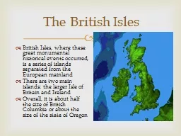
Section 1 England England Locate England on the map on page 289 The largest island in the British Isles and in all of Europe is Great Britain The island of Great Britain is made up of three independent countries England Scotland and Wales ID: 486547
Download Presentation The PPT/PDF document "Chapter 15: The British Isles and Nordic..." is the property of its rightful owner. Permission is granted to download and print the materials on this web site for personal, non-commercial use only, and to display it on your personal computer provided you do not modify the materials and that you retain all copyright notices contained in the materials. By downloading content from our website, you accept the terms of this agreement.
Slide1
Chapter 15: The British Isles and Nordic Nations
Section 1: EnglandSlide2
England
Locate England on the map on page 289
The largest island in the British Isles- and in all of Europe- is Great Britain.
The island of Great Britain is made up of three independent countries: England, Scotland and Wales
Together, with Northern Island , makes up Great Britain. Slide3
England’s Physical Characteristics
Made up of three different areas:
Highlands
Midlands
LowlandsA short distance to the south east are the Midlands. Here lie the thick veins of coal that fueled the country’s Industrial Revolution. Slide4
England’s Physical Characteristics Continued…
Highest populations of England are in the Midlands.
To the south and east are the lowlands
Lowlands tend to be fertile--- what does this mean?Slide5
England’s Physical Characteristics Continued…
The lowlands provide England with some of its most productive farms.
Farmers grow: wheat, vegetables, and other similar crops.
Also, this area is great for sheep, dairy and beef cattle. Slide6
Rise of London as a Trade Center
Europe always had a surplus of goods.
This lead to cities being developed along rivers and coast.
London became the most popular city---
Why???Slide7
London’s Relative Location
London is located on the Thames River.
The location always ships to sail right up to the ports of London. Slide8
Global Trade Patterns
The port of London grew rapidly in the 1500s because of changes in the patterns of world settlement and trade.
London became what is it today due to the location.Slide9
Economic Activities
In the 1500s, Britain shipped a lot of its products across the world fueling the Industrial Revolution.
Became known as “the workshop of the world”Slide10
The Rise of Heavy Industry
Earliest technological advances were used in to produce textiles or cloth.
Also had a lot of iron ore which made some cities triple in size.
Also was the leading producer of coal.
This helped England but at what cost? Slide11
Challenges to British Industry
In the late 1800s, Britain’s power was challenged by two new forces: Germany and the USA.
Now, Britain turned to its oil supply under the North Sea as a source of fuel. Slide12
Challenges to British Industry Continued…
Tertiary Economic Activities: service industry
Examples: finance, insurance, and tourism.
Europe is growing and its economy is doing very well. Slide13
Section 1 Assessment
2. Describe the three different physical areas of the English landscape.
3. What geographic factors affected London’s level of development?
4. A. What impact did technological innovations have on the British economy?
B. What impact did they have on Britain’s physical landscape?5. A. What was the effect of the Industrial Revolution on Britain’s coal supply?
B. How has the British economy recovered from the loss?Slide14
Section 2: Scotland and WalesSlide15
Scotland’s Physical Characteristics
Scotland occupies nearly one third of the land area in the United Kingdom, but only has less than 10% of the population
Landscape is ruggedSlide16
The Highlands
The highland region is a large, high plateau with many lakes, called lochs, which were carved by retreating glaciers
Moors?—
Bogs?---
This area has the best climate for fishing and sheep herding. Slide17
The Central Lowlands
South of the highlands runs a long lowland region.
75% of people live in this region.
However, due to economic hardships this area had a lot of people leave. Slide18
The Southern Uplands
Closest to the English borderPrimarily sheep-raising region
Produces a lot of woolSlide19
Scottish Culture
New industry are slowly taking the place of mining, steel making, and shipbuilding.
Today, Scotland drills for oil in the North Sea
Glen---???
Maintains its own culture –Give me examples on how they did this?Slide20
Wales
It is very different from England.Has its own
-capital
-postage stamps
-flag-languageSlide21
Welsh Physical Characterisitics
Wales is a peninsula of Great Britain
About the size of Massachusetts
Has a marine west coast climate
Usually receives more rain than EnglandSlide22
A Separate Language
Some Welsh have sat on English Parliament however they are seeking cultural independence.
The key to preserve Welsh culture is language
2.9 Million people speak English
20% still speak WelshSlide23
Economic Activities
Very similar to the economic history of England and Scotland
Capital city: Cardiff
In the early 1900s, Wales fell really behind in technology
-In the 1980s, people lost their jobs and quit schoolIn the 1990s, it began to improve slightlySlide24
Section 2 Assessment
2. What are the major physical characteristics of Scotland?
3.A.In what ways has Scotland preserved its cultural heritage?
B. How have the Welsh maintained their cultural identity?
4. What role has technology played in the economic changes that have occurred in Wales between the late 1800s and today?5. Analyze the survival of the Welsh language in modern Welsh society. What does it say about Welsh society’s view of cultural change?Slide25
Section 3: The Two IrelandsSlide26
Ireland’s Physical Characteristics
Hills ring most of the coastline
The middle of the Island is a plain that drains into River Shannon
-Has a marine west coast climate that keeps the island very green.
1/6 of the island is covered in peat (a spongy material containing waterlogged mosses and plants)Slide27
Cooperation and Conflict
Celtic tribes from Europe first settled Ireland around 300
b.c
.
Repeatedly defended off the VikingsIn 1066, Norman invaders invaded England and tried to take over the IrishBanned marriages between Normans and Irish
Banned Celtic language (Gaelic)
Outlawed Celtic musicSlide28
Cooperation and Conflict
King Henry II of England declared himself Lord of Ireland in 1171 and tried unsuccessfully to force Norman Lords to obey him.Slide29
Religious Conflicts
Up to the 1500s, Roman Catholics ruled most of Europe until the Reformation. Where Protestant religion was introduced.
Most of the Irish remain Catholic while most of the English switch to Protestant.
The division led to bitter conflicts between Irish Catholics and landlords sent from England. Slide30
Religious Conflicts Continued…
The Protestant minority controlled most of the wealth while the Irish Catholics were very poor.
Led to Cultural Divergence: deliberate efforts to keep the cultures separated.
The Potato Famine hit Ireland in the 1840s.
A blight, or plant disease, destroyed the potato crops year after year. Slide31
Government and Citizenship
Rebellions between 1916-1921 led officials in the United Kingdom and Ireland to divide the island into 2 parts.
The 6 northeastern counties remained part of Great Britain, the rest were independent.
Became officially independent in 1949, but did not end conflict. Slide32
Government and Citizenship
A little over half of Northern Ireland’s people are Protestant, the rest are Catholic.
Both sides remain quite violent in trying to get control over Northern Ireland.Slide33
Economic Activity
In the 1990s, The Irish government tried to improve several parts of their society including:
Education
Telecommunication
Was very successful! -Per capita increased
-unemployment fell to 3.8%
-increased immigration
In 1990, Ireland adopted the Euro.
Slide34
Section 3 Assessment Questions
2. Why is Ireland called the Emerald Island?
3. Describe the geographic processes that led to the formation of two political units in Ireland.
4. How has the government of Ireland tried to improve the economy?
5.a. Determine whether or not the following is a fact or opinion:“Protestants and Catholics in Northern Ireland both feel threatened by the past and are reluctant to negotiate.”
B. Do you agree or disagree with this statement? Explain. Slide35
The Nordic NationsSlide36
NorwaySlide37
SwedenSlide38
FinlandSlide39
DenmarkSlide40
IcelandSlide41
Physical Characteristics
It is identified because its “North”
A collection of peninsulas an islands separated by seas, gulfs, and oceans.
Varies drastically among nationsSlide42
Environmental Change
Much of the landscape on the Scandinavian Peninsula is the product of the last ice age.
1000s of lakes are located in this region.
Soil is very rocky and hard to farm. Slide43
Environment Change Continued…
When the glaciers melted, water filled the valleys, creating flooded glacial valleys known as fjords (FEE YAWRDZ)
Some of the fjords are so deep boats can sail on them in order to go to the ocean. Slide44
Natural Resources
In Iceland, volcanoes and glaciers exist side by side.
Allows them to produce geothermal energy: or energy produced from the heat of the earth’s interior. Slide45
Long Winters, Short Summers
At midwinter, the sun may shine only 2 or 3 hours a day.
In midsummer, it shines more than 20 hours a day.
Can see the northern lights from this area of the worldSlide46
The Ocean and the Climate
Climate is surprisingly mild
Mild marine west coast climate due to the warm currents of the North Atlantic Drift
Coldest area is east of a mountain chain that runs northeast to southwest Norway.Slide47
Understanding the Past
The Vikings were originally from this area of the world.
The five countries were briefly united under Queen
Margrethe
of Denmark in 1397. The union ended in 1523 when Sweden withdrew. Most Nordic people belong to the Lutheran Church. All have a language with similar roots and all understand English.Slide48
Economic Systems
All five nations are democracy
All have mixed economies---what are mixed economies?
Some of the countries such as Denmark and Sweden have state-run day-care centers and state-supported
medicareUsually neutral in foreign affairs.Slide49
Economic Activities
Have sound economies
Denmark and Southern Sweden have flat land and a mild climate
Denmark uses 60% of its land for farming
Norwegians use fishing techniques. This region also benefits from oil and gas .