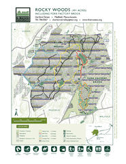
PDF-This map is a product of the Geographic Information System o The Trust

Author : celsa-spraggs | Published Date : 2015-10-13

HARTFORD STREETTO MEDFIELD TO WESTWOOD RT 95 123456781415161713121110987654321 P P EchoPondJunePondNotchPondLittle ChickeringPondQUARRYWHALE ROCKPARKING RESERVED

Presentation Embed Code

Download Presentation

Download Presentation The PPT/PDF document "This map is a product of the Geographic ..." is the property of its rightful owner. Permission is granted to download and print the materials on this website for personal, non-commercial use only, and to display it on your personal computer provided you do not modify the materials and that you retain all copyright notices contained in the materials. By downloading content from our website, you accept the terms of this agreement.

This map is a product of the Geographic Information System o The Trust: Transcript


HARTFORD STREETTO MEDFIELD TO WESTWOOD RT 95 123456781415161713121110987654321 P P EchoPondJunePondNotchPondLittle ChickeringPondQUARRYWHALE ROCKPARKING RESERVED FORPAVILLION GROUPSMINE HILL420 ft. LT: Students will begin to understand the concept of geographic luck by exploring the story of crops and animals around the world. . What is . “Geographic Luck”?. Developed by . Jared . Diamond. Tries to answer the question: W. Applications in marketing. Austin College. April 2014. Dr. Ronald Briggs. Professor Emeritus. The University of Texas at Dallas. Program in Geospatial Information Sciences. briggs@utdallas.edu. Overview. I can use a capital letter for the beginning of holidays, product names, and geographic names.. What is a holiday?. What are geographic names?. What is a product?. How do you know which words need a capital letter?. Projections and Cartographers. First 10 Minutes: Turn in your Physical Features of the USA map. Reminder! News Quiz Tomorrow. . Geographic definitions:. Map. -a representation of a part of our planet. OT 122. Chapter Six. Introduction. Geographic Filing. Records are sorted by location. Geographic Filing Procedures. Step One – Inspecting. Release mark!. Step Two – Indexing. Look for correspondent’s location 1st. @ . GPLS: Guam Public Library System. How to Go There & What to Get There. Femelyne C. Wesolowski. LIBR 210 Reference San Jose State University. July 7, 2013. National Geographic Society. Mission. Harvard Extension School. ISMT-E155. Jeff Blossom, Instructor. jblossom@cga.harvard.edu. Lecture . 10: How to Lie with Maps. 1. April 27, 2011. Geographic Communication Today 4/27/2011. 5:30 – 6:00 How to Lie with Maps, cartographic deception. Week 8. : . R. aster Data Model. Geographic Extent and Unit of Analysis. Data Sources. Geographic Information Systems I | Department of Geography, DePaul University. Nandhini Gulasingam . Subhay. . manandhar. Geographic Information Systems (GIS). - . System.  designed to capture, store, manipulate, analyze, manage, and present all types of spatial or . geographical.  data. .. - GIS consists of 3 components . In your notebook, title: Geographic Luck answer the following question. Why do some countries have an abundance of wealth and riches while others have remained poor for most of their history?. Jared Diamond’s Theory of Geographic Luck. three main types: . . Global Positioning Systems. Remote Sensing. Geographic Information Systems. One of a Set. Defining GIS. Different definitions of a GIS have evolved in different areas and disciplines . Factory Shoals Middle School. Mr. L. Smith. Day 14-17 Ethnic/Religious Groups. AFRICA. Standard: SS7G4. Describe the diverse cultures of the people who live in Africa. . a. . Explain the differences between an ethnic group and a religious group. (GIS) is a system designed to capture, store, manipulate, analyze, manage, and present all types of geographical data. -- Wikipedia. maps. data. tools. computers. Geography is visualized in maps. www.arcgis.com. Baddley JW, Winthrop KL, Patkar NM, Delzell E, Beukelman T, Xie F, et al. Geographic Distribution of Endemic Fungal Infections among Older Persons, United States. Emerg Infect Dis. 2011;17(9):1664-1669. https://doi.org/10.3201/eid1709.101987.

Download Document

Here is the link to download the presentation.
"This map is a product of the Geographic Information System o The Trust"The content belongs to its owner. You may download and print it for personal use, without modification, and keep all copyright notices. By downloading, you agree to these terms.

Related Documents