/
Groundwater Groundwater

Groundwater - PowerPoint Presentation

conchita-marotz
conchita-marotz . @conchita-marotz
Follow
478 views
Uploaded On 2015-12-03

Groundwater - PPT Presentation

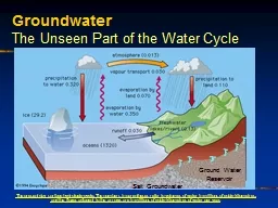
Porosity and Permeability In order for rocks to transmit water oil or gas they must possess two properties 1 porosity and 2 permeability Porosity can be of two types The first is intergranular porosity which consists of pores between grains such as the quartz grains in a sandstone ID: 212791

watertable water pressure surface water watertable surface pressure porosity aquifer called permeability aquifers cave confined system wells drop fractures

Share:

Link:

Embed:

Download Presentation from below link

Download Presentation The PPT/PDF document "Groundwater" is the property of its rightful owner. Permission is granted to download and print the materials on this web site for personal, non-commercial use only, and to display it on your personal computer provided you do not modify the materials and that you retain all copyright notices contained in the materials. By downloading content from our website, you accept the terms of this agreement.


Presentation Transcript

Slide1

Groundwater Slide2

Porosity and Permeability

In

order for rocks to transmit water, oil, or gas they must possess two properties, 1) porosity and 2) permeability. Porosity can be of two types. The first is inter-granular porosity which consists of pores between grains such as the quartz grains in a sandstone

not filled

with

minerals.

The second type of porosity

is fracture porosity. It depends

on the presence of fractures that

all near-surface rocks have. However, in

order for a fluid to flow through a rock, having porosity is, by itself, not enough. Pores and fractures must be interconnected in order to allow the flow of the

fluid (blue areas).

The degree to which the pores or fractures are interconnected and, as a result, the ease with which fluids will flow through a rock is called permeability.Slide3

The

Watertable

As

rainwater or snow/ice melt accumulates on the surface, it begins to percolate downward to become groundwater. Once below the surface, the water will continue to percolate downward as long as it encounters rocks with sufficient porosity and permeability to allow it to move. Eventually, the weight of the overlying rock section will close any pores and fractures, eliminating both porosity and permeability. On the average, the deepest groundwater will penetrate below ground level is about 2,500 feet. At this point the pores begin to fill with water, forming a zone of saturation. Above the zone of saturation there is a zone called the zone of aeration in which there is no groundwater except when rain water or snow/ice melt waters are moving down to the zone of saturation. The contact between the zones of saturation and aeration is called the watertable. The distance from the surface to the watertable is mainly determined by the amount of annual precipitation. Hydrologist identify the watertable with an inverted triangular icon.Slide4

Aquifers

Rocks that exhibit high porosity and permeability are called aquifers. Those that have little or no porosity or permeability are called

aquicludes

. In between these two are aquitardes. The ideal aquifers are listed in the illustration. Of these, sandstones are usually the best. Aquicludes consist of mostly unweathered igneous and metamorphic rocks and, because of their natural fine-grained character, chemical limestones. The importance of the diagram shows that, except for shales which are almost always aquicludes because of the lack or permeability, the porosity and permeability of any aquiclude can be increased when exposed to weathering, the diagonal line on the diagram. As even igneous and metamorphic rocks are weathered, porosity and permeability increase. Eventually, the porosity and permeability qualify the weathered rock to become an aquitard and eventually, an aquifer. Slide5

Confined Aquifers

A

confined aquifer requires a highland adjoining a lowland. The confined aquifer consists of a very good aquifer sandwiched between two equally good aquicludes. The confined aquifer underlies the lowland and comes to the surface along the summit of the highland where the aquifer is recharged. Once water enters and fills the aquifer along the recharge area, it is confined by virtue of the overlying and underlying aquicludes. Being confined, pressure develops within the aquifer in much the same way that pressure develops in pipes being fed by an elevated water tank. But some of the pressure energy is consumed by friction within the pore spaces. As a result, confined aquifers have an actual pressure surface to which the water will rise if penetrated by a well. Note that the actual pressure surface begins at the upper surface of the water in the aquifer and drops away from the recharge area, eventually to drop down to the level of the aquifer. All wells that produce water from a confined aquifer are called artesian wells. Those that produce water above the ground surface are referred to as free-flowing artesian wells and do not have to be pumped while those that rise to an actual pressure surface at or below the ground surface will require the water to be pumped to the surface. Over-production from confined aquifers drops the pressure surface to the point that it eliminates all free-flowing wells while reducing overall water production.Slide6

Types of

Watertables

A regional

watertable exists everywhere within a region and, in general, follows the lay of the land except for being deeper under ridge summits than under valley floors. The level of water in a stream, wetland, lake, or pond is where the regional watertable cuts across a topographic low. The amount of water that exists within any surface body of water will vary depending on the location of the watertable which, in turn depends on the amount of precipitation. This explains why stream levels rise following periods of rain and drop during periods of drought. If periods of drought are sufficiently long, the watertable may drop below the bottom of the water-body in which case the water-body will disappear.

Click

O

n Illustration

For More…

A

hanging or perched

watertable

occurs where

an

aquiclude

is present within the rock section above the regional

watertable

. As rainwater or snow melt percolates downward, it encounters the

aguiclude

and, prevented from percolating further, collects above the

aquiclude

creating a hanging or perched

watertable

. Where the strata are horizontal, it is not uncommon for springs to occur where the edge of the hanging

watertable

encounters the surface of the hill. The water one sees emerging from

roadcuts

is groundwater spilling out of breached hanging

watertables

. There may be any number of perched

watertables

located above the regional

watertable

.Slide7

Formation of Caves and Caverns

Most

caves and cavern are formed by the dissolution of limestone beds during the period that the limestone is below the watertable. Initially, water flows through limestone beds by following fractures called joints that occur in two mutually perpendicular sets. In drawing “a”, the solid black line represents water beginning to enter and flowing through a sets of joint fractures in limestone. Because the rock is water soluble, with time a very thin film of water flowing along the fractures will open them and allow increasing volumes of water to flow through the limestone. Over time these passageways can be enlarged as the watertable drop (dashed line and a triangular-shaped marker). At some point, drawing “c”, the watertable has dropped below the roof of the passageways. Continued erosion of the surface and dissolution of the limestone will eventually form a system of caves and caverns that follow the original joint pattern. As long as the watertable is located above the floor of the cave, it will be a wet system with water flowing in streams and pooling in ponds or lakes. Eventually, when the watertable has dropped below the floor of the cave, the system becomes dry as shown in drawing “e”.Slide8

Creation of

Speleothems

Once

a cave system is located above the watertable, structures consisting of calcite, commonly referred to as dripstone, begin to form. As water percolates downward from the surface attempting to penetrate to the watertable, it must cross the cave system. As the waster moves through the limestone within the roof of the cave, it dissolves some of the calcite and forms a drop on the cave roof that eventually drops to the cave flow and spatters. As the water evaporates, a tiny bit of calcite is deposited on the roof of the cave where the drop originated and on the floor of the cave where it fell and spattered. Over millions of years this process creates structures called speleothems that hang from the ceiling of the cave and build up from the floor. Hanging structures are called stalactites while those building from the floor are called stalagmites. Spelunkers or cavers also have other descriptive names such as bacon rind and bridal veils to describe individual speleothems based on their appearance.Slide9

Types of

Waterwells

A well is a hole dug or drilled down below a

watertable that fills with water. From the first known water well dating back several thousand years BC, up to the early 1800s, water wells were deep enough to intersect a sufficient number of aquifers. To prevent the collapse of the hole, the well was lined with timbers or blocks of rock. Some of the world’s oldest wells are located in the Middle East. The first drilled water well was in southern West Virginia but it was actually completed to obtain brine water to make salt. All water wells must penetrate a watertable, be it regional or hanging, and encounter a sufficient number of aquifers to provide useable amounts of potable water. For the average U.S. family of mom, dad, and 2 ½ children, the average weekly consumption of water is 2,500 gallons.

For

wells producing water from

unconfined

aquifers, the water within a well will

always rise

to the level of the

watertable

.

Click

O

n Illustration

For More…

When water is being pumped from a well, not only will the water level within the well drop, but the

watertable

surrounding the well will be depressed in the form of a cone called the cone of depression. How big the cone of depression will get depends on the rate at which water is being removed from the aquifer system and how fast it is being replaced by recharge. Overproduction from unconfined aquifers result in the overlapping of cones of depression and the subsequent lowering of the

watertable

.Slide10

Municipal Water System

The municipal

water system is an artificial confined aquifer. The recharge areas are reservoirs or water towers located within the area of the city. An actual pressure surface extends out from each reservoir or water tower and overlap so that

all of the citizens are located under one or more of the pressure surface umbrellas. In order to have all the customers under a pressure surface, any expansion of the city limits requires the building of additional reservoirs or water towers. The pressure at any home or business will simply be determined by the distance between their faucets and the pressure surface. Note, however, that because of the shape of the pressure surface, customers at the fringe of the system will always have low water pressures and, at times of high demand, may receive no water at all if the pressure surface drops below their faucets.