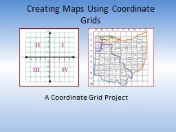
A Coordinate Grid Project Timeline Day 1 Introduction to Maps Start Classroom Map Day 2 Finish Classroom Map Share Maps Discuss difficulties of Mapping an Entire School Get in Teams and Brainstorm ID: 724742
Download Presentation The PPT/PDF document "Creating Maps Using Coordinate Grids" is the property of its rightful owner. Permission is granted to download and print the materials on this web site for personal, non-commercial use only, and to display it on your personal computer provided you do not modify the materials and that you retain all copyright notices contained in the materials. By downloading content from our website, you accept the terms of this agreement.
Slide1
Creating Maps Using Coordinate Grids
A Coordinate Grid ProjectSlide2
Timeline
Day 1: Introduction to Maps Start Classroom MapDay 2: Finish Classroom Map Share Maps
Discuss difficulties of Mapping an Entire SchoolGet in Teams and BrainstormDay 3: Explore the School with Your Team and Start Mapping.
Day 4:
(In Class) Constructing Map and Coordinate Grid
Day 5:
Finish Map and Coordinate Grid
Day 6:
Create Directory
Day 7:
Maps ready to shareSlide3
What are maps?
Discuss as a team: What do you already know about maps? Slide4
Political Maps
Shows boundaries and locations of cities.Slide5
Physical Map
Shows physical landscapes; rivers, lakes, mountains; etc.Slide6
Topographical Map
A physical map that also show elevations.Slide7
Climate Map
Shows climate (weather) zones for areas.Slide8
Economic Map
Type of map that shows the economic activity or natural resources in an area.Slide9
Road Map
Map that shows the major and/or minor highways and roads in the area.Slide10
What kind of Maps have you used?
As a team, discuss your experience with various types of maps.When have you used a map?What are some different situations where you would need to use a map in real life?
What are some different types of maps people encounter?Slide11
What about a Map of the Mall?Slide12
Why would you use a Map of the Mall?
Because it shows you where you are and how to get where you need.Slide13
Notice…
This map is color-coded and letter-coded. Why?So you can locate the store you are looking for easier.Slide14
It’s kind of like longitude and latitude lines do on a globe…
It gives you coordinates!!Slide15
Latitude
A geographic coordinate that specifies the north-south position of a point on the Earth's surface.Slide16
Longitude
A geographic coordinate that specifies the east-west position of a point on the Earth's surface.Slide17
If you’re looking for the coordinates of a certain country on a globe, if you have the proper coordinates you can find it.Slide18
What about a map of a school?Slide19
Could we create a coordinate map so we could locate classrooms; etc. easier?Slide20
Today, you are going to start with mapping out your classroom
Before creating a school map, start by creating a map of your classroom using a coordinate grid.Use the instructions below to guide you in this process.Slide21
Step one: we must set a scale.
Scale is the ratio of a distance on the map to the corresponding distance on the groundSlide22
Scale
For this classroom I used a scale of 1 cm = 1.25 feet.Slide23
Step 2: Using paper and a ruler draw the classroom as you see it, keeping SCALE in mind.Slide24
Step #3: Draw a coordinate grid on top of your scaled drawing. Make sure the lines are evenly spaced and drawn neatly.Slide25
Step 4: Using a different color pen or pencil, divide the class into quadrants.Slide26
What are quadrants?
The two axes divide the coordinate grid into four areas called quadrants. The first quadrant, by convention, is the top right, and then they go around counter-clockwise.Slide27
Step 5: Create a Directory of AT LEAST 10 Locations along with Coordinates, and Quadrants
Locations
CoordinatesQuadrant
Bookshelf
{7,8}
1
Closet
{11, -8}
4
Computers
{-12, 1}
2 & 4
File Cabinet
{11, 0}
1 & 4
Group Table
{-2, 5}
3 & 4
Lockers
{-6, 8}
1 & 2
Sink
{11, 8}
1
Teacher’s
Desk
{11, -4}
4
Tristan’s Desk
{-7, 4}
2
Brooklyn’s Desk
{7, -4}
4
Cooper’s Desk
{7, -4}
1Slide28
Your finished product should be a coordinate grid map (with quadrants) and a directory.Slide29
Extending your learning…
Now, can you work as a team to create a coordinate grid mapping of the school; complete with a scale and a directory that shows the coordinates and quadrant of at least 20 locations?(Perhaps these maps could be used to help visitors to our school) Slide30
Final School Map
Your school map should be able to be used by an adult or another 5th grader. You should be able to hand them your map and directory of at least 20 places. After a brief explanation of how to read the map, they should be able to use the map to walk around the school and locate destinations that THEY would like to visit. Your map should be ready to use by visitors to our school. Slide31
Project Rubric