PPT-Geography of the Fertile Crescent
Author : faustina-dinatale | Published Date : 2016-04-13
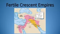
68 On a historical map locate and describe the Tigris and Euphrates Rivers Zagros and Caucuses Mountains Persian Gulf Caspian and Black Sea Dead Sea and Sea of Galilee
Presentation Embed Code
Download Presentation
Download Presentation The PPT/PDF document "Geography of the Fertile Crescent" is the property of its rightful owner. Permission is granted to download and print the materials on this website for personal, non-commercial use only, and to display it on your personal computer provided you do not modify the materials and that you retain all copyright notices contained in the materials. By downloading content from our website, you accept the terms of this agreement.
Geography of the Fertile Crescent: Transcript
Download Rules Of Document
"Geography of the Fertile Crescent"The content belongs to its owner. You may download and print it for personal use, without modification, and keep all copyright notices. By downloading, you agree to these terms.
Related Documents