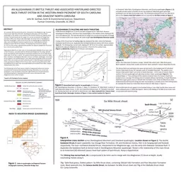
/
AN ALLEGHANIAN (?) BRITTLE THRUST AND ASSOCIATED AN ALLEGHANIAN (?) BRITTLE THRUST AND ASSOCIATED

AN ALLEGHANIAN (?) BRITTLE THRUST AND ASSOCIATED - PowerPoint Presentation

giovanna-bartolotta
giovanna-bartolotta . @giovanna-bartolotta
Follow
358 views
Uploaded On 2019-02-14

AN ALLEGHANIAN (?) BRITTLE THRUST AND ASSOCIATED - PPT Presentation

HINTERLANDDIRECTED BACKTHRUST SYSTEM IN THE WESTERN INNER PIEDMONT OF SOUTH CAROLINA AND ADJACENT NORTH CAROLINA John M Garihan Earth amp Environmental Sciences Department ID: 751907

fault thrust alleghanian mountain thrust fault mountain alleghanian figure table rocks rock sheet directed standingstone caesars gneiss head mile

Share:

Link:

Embed:

Download Presentation from below link

Download Presentation The PPT/PDF document "AN ALLEGHANIAN (?) BRITTLE THRUST AND AS..." is the property of its rightful owner. Permission is granted to download and print the materials on this web site for personal, non-commercial use only, and to display it on your personal computer provided you do not modify the materials and that you retain all copyright notices contained in the materials. By downloading content from our website, you accept the terms of this agreement.


Presentation Transcript

Slide1

AN ALLEGHANIAN (?) BRITTLE THRUST AND ASSOCIATED HINTERLAND-DIRECTED BACK-THRUST SYSTEM IN THE WESTERN INNER PIEDMONT OF SOUTH CAROLINA AND ADJACENT NORTH CAROLINAJohn M. Garihan, Earth & Environmental Sciences Department, Furman University, Greenville, SC 29613

An unnamed, NW-directed brittle thrust, interpreted to be

Alleghanian

age, has been traced across Table Rock, Brevard*, Standingstone Mountain, and Horse Shoe* quadrangles in the western Inner Piedmont (IP) of South Carolina and adjacent North Carolina. The fault bounds the SE margin of a narrow outcrop belt of Chauga River Formation (CRF) rocks along its NE-strike length. At Dismal Creek in Standingstone Mountain quadrangle, a splay of this thrust near its leading edge has displaced the older, early-mid Paleozoic Eastatoee ductile thrust (ie. duplicated the footwall Henderson Gneiss-CRF thrust contact). The Slicking Gap normal fault, dipping 25°-30° SE at the surface, approximately parallels the adjacent Alleghanian thrust and lies 1-3 km SE of its surface trace. Regionally Six Mile thrust sheet rocks lie structurally above Walhalla thrust sheet rocks in the IP. However, associated with the NW-directed Alleghanian thrusting, Walhalla thrust sheet gneisses were back-thrust toward the hinterland over the Six Mile thrust sheet rocks, to the SW, S, and SE. This system of brittle back-thrusts is present in Table Rock, Cleveland, Standingstone Mountain, Zirconia, and Slater quadrangles. Some back-thrusts appear to be localized along or near older greenschist-grade ductile muscovite-quartz shear zone schists and strain-softened zones in Table Rock gneiss produced by earlier gravitational collapse of the IP thrust stack. Back-thrusting deformed Six Mile and Walhalla thrust sheet rocks and locally folded and truncated these older, collapse-related ductile shear zones. The Slicking Gap normal fault may be related to hanging wall extensional stresses associated with hinterland-directed back-thrusting. Alternately, the normal fault developed, or was reactivated, during later regional Mesozoic SE-ward extension. The Slicking Gap fault is interpreted to be listric and to reactivate the older Alleghanian thrust surface at depth. *based on NC Geological Survey mapping

ABSTRACT

In Cleveland, Table Rock, Standingstone Mountain, and Zirconia quadrangles (Figures 1, 2),a broadly arcuate system of brittle thrusts has emplaced Table Rock gneiss generally southward over Six Mile thrust sheet rocks. The hinterland-directed thrusts are referred tohere as the Caesars Head fault system and are indicated by the blue arrows on Figure 3.

INDEX TO MOUNTAIN BRIDGE QUADRANGLES

Figure 1.

Index to quadrangles and Regional Tectono-Stratigraphic Summary, Mountain Bridge area

ALLEGHANIAN (?) FAULTING AND

BACK-THRUSTING

A NW-directed

Alleghanian (?) thrust has been mapped across Table Rock, Brevard,Standingstone Mountain, and Horse Shoe quadrangles in the western Inner Piedmont (IP) of SC and adjacent NC. The fault bounds the SE margin of a narrow outcrop belt of ChaugaRiver Formation (CRF) rocks along its NE-strike length (see Standingstone Mountain quad).A splay of this thrust near its leading edge has displaced the older, early-mid Paleozoic Eastatoee ductile thrust (ie. duplicated the footwall Henderson Gneiss-CRF thrust contact, Figure 4). The Slicking Gap normal fault, dipping 25°-30° SE at the surface, approximately parallels the adjacent Alleghanian thrust and lies 1-3 km SE of its surface trace(Figure 2, labeled SG; Alleghanian (?) thrust is not shown).

Figure

2. Generalized fault map for six quadrangles (B- Brevard, SM- Standingstone Mountain, Z- Zirconia, S- Slater, Cl- Cleveland, TR- Table Rock). Location ofHyde Mountain klippe shown. CC-SB- Cox Creek-Short Branch fault. PC- Palmetto Cove fault. SG- Slicking Gap fault; bar and ball on downthrown side. Open sawtooth line- Caesars Head back-thrust faults. Rectangle- location of Figure 3. Cross section location for Figure 4.

Figure 3.Green- Poor Mountain Formation; orange- Tallulah Falls schist; pink- Table Rock gneissBlack sawteeth- Seneca fault, locally overturned. Open sawteeth- Caesars Head back-thrustsThe Seneca fault and overlying rocks were carried south in the hanging wall of individual Caesars Head back-thrusts, for example south of Campbell Mountain. The eastern-most Caesars Head system fault is an outlier at Hyde Mountain, ~15 km east of Caesars Head in southern Zirconia quadrangle and adjoining northern Slater quadrangle (Figure 2). The isolated klippe is ~7 km southeast of the nearest erosional trace of a Caesars Head fault, located across a younger NE-striking zone of complex oblique-slip faulting. At Hyde Mountain, Table Rock augen gneiss rests on Tallulah Falls Formation rocks of the Six Mile thrust sheet. Hinterland-directed back-thrusting was later transected by a complex zone of NE-striking faults, for example the steep Cox Creek-Short Branch fault (CC-SB) shown in Figure 2. Some brittle back-thrusts appear to be localized along or near older ductile shear zones and strain-softened zones in Table Rock gneiss. Macro-scale folding of Six Mile thrust sheet rocks is associated with back-thrusting.

Figure 4

.Interpretive cross section across Standingstone Mountain and Cleveland quadrangles. Location shown on Figure 2. The ductile Eastatoee thrust, E (open sawteeth), has Chauga River Formation, CR, and Henderson Gneiss, HGn in its hanging wall and footwall, respectively. The main northwest-directed thrust, interpreted to be Alleghanian age, cuts the early-mid–Paleozoic Eastatoee fault. It duplicates the Eastatoee fault at Dismal Creek in Standingstone Mountain quadrangle. Shown is the relationship of this main thrust to its hinterland (SE)-directed Caesars Head fault system of back-thrusts. Ramp is hypothetical. The Slicking Gap normal fault, SG, is conjectured to be listric and to merge with the Alleghanian (?) thrust at depth, locally reactivating motion along it.TRg- Table Rock gneiss. Dotted pattern- Six Mile thrust sheet, containing Tallulah Falls Formation and Poor Mountain Formation rocks. Black sawtooth line, the Seneca ductile thrust, lies between Six Mile thrust sheet and TRg of the Walhalla thrust sheet. CG- Camp Greenville.

Alleghanian

(?) thrust

b

ack-thrusts

NW-directed Seneca thrust

Alleghanian

(?) thrust

Alleghanian

(?)

thrust

a

long strike projected

i

nto line of main cross section