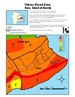
Ilana Stout TCBES 670 Spring 2014 The Problem Farmers and gardeners in Hawaii need to share information about which crop varieties perform well in specific climate conditions Current plant hardiness zone systems do not accurately represent the diverse growing conditions found in Hawaii ID: 303092
Download Presentation The PPT/PDF document "Plant Hardiness Zones Unique to Hawaii C..." is the property of its rightful owner. Permission is granted to download and print the materials on this web site for personal, non-commercial use only, and to display it on your personal computer provided you do not modify the materials and that you retain all copyright notices contained in the materials. By downloading content from our website, you accept the terms of this agreement.
Slide1
Plant Hardiness Zones Unique to Hawaii Climates
Ilana Stout
TCBES 670
Spring 2014Slide2
The Problem:
Farmers and gardeners in Hawai’i need to share information about which crop varieties perform well in specific climate conditions.
Current plant hardiness zone systems do not accurately represent the diverse growing conditions found in Hawai’i.Slide3
USDA Zones: Annual Minimum Temperature Only
http://planthardiness.ars.usda.govSlide4
Sunset Climate Zones: Include rainfall…
…but only define 2 zones!
http://www.sunset.com/garden/climate-zones/sunset-climate-zone-hawaiiSlide5
Hawai’i Public Seed Initiative State Variety Survey
Objectives:
Create map or maps of growing conditions in Hawai’i
Survey farmers and gardeners across the state about successful varieties
Develop
i
nteractive tool for online information sharing Slide6
What factors to include?
Canada’s Plant Hardiness Factors are determined by 7 factors !
Y = -67.62 + 1.734X₁ + 0.1868X₂ + 69.77X₃ + 1.256X₄ + 0.006119X₅ + 22.37X₆ - 0.01832X₇ where:
Y = estimated index of suitability
X₁ = monthly mean of the daily minimum temperatures (°C) of the coldest month
X₂ = mean frost free period above 0°C in days
X₃ = amount of rainfall (R) from June to November, inclusive, in terms of R/(
R+a
) where a=25.4 if R is in millimeters and a=1 if R is in inches
X₄ = monthly mean of the daily maximum temperatures (°C) of the warmest month
X₅ = winter factor expressed in terms of (0°C - X₁)
R
jan
where
R
jan
represents the rainfall in January expressed in mmX₆ = mean maximum snow depth in terms of S/(S+a) where a=25.4 if S is in millimeters and a=1 if S is in inchesX₇ = maximum wind gust in (km/hr) in 30 years http://planthardiness.gc.ca/index
In Hawai’i, the most important factors are: Rainfall, Elevation ( a proxy for Temperature)Slide7
Data Set: Rainfall
Moisture zones
developed for HCSU
Technical Report
008: Mapping Plant Species in the Hawaiian Islands: Developing a Methodology and Associated GIS Layers
Moisture zones include both rainfall and potential evapotranspirationSlide8
Data Set : Elevation
100ft Contours from
Office of Planning : Hawaii Statewide GIS ProgramSlide9
1000, 2000, 3000, 4000
ft
contoursSlide10
Polygons for 5 distinct elevation zonesSlide11
Moisture Zones Intersect with ContoursSlide12
7 Moisture Zones x 5 Elevation Zones = too many zones! Slide13
Combined Moisture Zones of Similar TypeSlide14Slide15
Further steps
Seasonality
Soils
Storymap
Jonathan PriceSlide16
Refrences
Price, J. P. 2012. Mapping plant species ranges in the Hawaiian Islands: developing a methodology and associated GIS layers.US Department of the Interior, US Geological SurveySlide17
Suggestions?
Want to participate?
Please contact me at
istout@hawaii.edu
Thanks to Dr.
Ryan Perroy
, Dr.
Jonathan Price,
Lyn Howe and the members of the Hawaii Public Seed Initiative Slide18