/
Welcome to the Tower Area Welcome to the Tower Area

Welcome to the Tower Area - PDF document

holly
holly . @holly
Follow
343 views
Uploaded On 2020-11-23

Welcome to the Tower Area - PPT Presentation

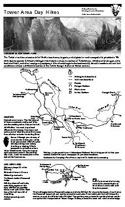
The Tower area was a crossroads for Native Americans trappers and explorers151and a campsite for presidents We invite you to spend a few hours hiking in this historic and scenic section of Yell ID: 822267

area trail miles tower trail area tower miles yellowstone road river hellroaring creek park bears northeast trailhead distance hill

Share:

Link:

Embed:

Download Presentation from below link

Download Pdf The PPT/PDF document "Welcome to the Tower Area" is the property of its rightful owner. Permission is granted to download and print the materials on this web site for personal, non-commercial use only, and to display it on your personal computer provided you do not modify the materials and that you retain all copyright notices contained in the materials. By downloading content from our website, you accept the terms of this agreement.


Presentation Transcript

Welcome to the Tower AreaThe Tower area
Welcome to the Tower AreaThe Tower area was a crossroads for Native Americans, trappers, and explorers—and a campsite for presidents. We invite you to spend a few hours hiking in this historic and scenic section of Yellowstone. Always carry rain gear, extra food and water, and other emergency equipment when venturing into the backcountry. Be sure to obtain current trail condition and bear activity information at the Tower Ranger Station or visitor centers.Hellroaring To MammothGarnetTo MountWashburnTower FallTreeYellowstone River Picnic Area Slough CreekTrailRidge TrailheadHellroaring CreekLamar RiverTrail not describedLost Lake LoopDistance, loop: 2.8miles (4.6 km)Estimated time: 1-2 hoursDiculty: moderateTrailhead: behind Roosevelt LodgeOering views of Lost Lake, waterfowl, sagebrush hill-tops, wildowers, possibly beavers and quite often black bears, this trail has a bit of everything. Trail frequented by stock animals.To Northeast To MammothTo0.4 mi0.7 km1.1 mi1.1 mi0.2 miPetried TreeRooseveltLodgeThis trail begins behind Roosevelt Lodge and climbs 300 feet (91 m) onto the bench. Here it joins the Roosevelt horse trail and continues west to Lost Lake. From Lost Lake the trail follows the contour around the hillside to the Petried Tree parking area, crosses the parking lot and contin-ues up the hill. It loops behind Tower Ranger Station, crosses the creek and returns to the lodge. Tower Area Day HikesCautionsHydrothermal areas: The thin ground in these areas breaks easily, and often overlies scalding water. Stay on the trail.All Wildlife: You must stay at least 100 yards (91 m) away from bears and wolves; and at least 25 yards (23from all other animals—including birds.Bears: Although your chance of an encounter is low, your safety is not guaranteed. Minimize your risks by making loud noises, shouting, or singing. Hike in groups and use caution where vision is obstructed. Carry bear spray and know how to use it. Do not hike after dark. Avoid carcasses; bears often defend this food source. National Park Service U.S. Department of the Interior Yellowstone National ParkI If you encounter horses, move to the downhill side of the trail and remain still until they have passed. Fishing: Anglers must have a Yellowstone National Park shing permit in their pos-session. Consult the park newspaper for purchase locations.Backcountry Camping: Permits are required for backcountry camping.For more informationwww.nps.gov/yellYell 237 • 02−15Garnet Hill LoopDistance, round trip: 7.6 miles (12.5 km)Estimated time: 4-5 hoursDiculty: ModerateTrailhead: Approximately 50 yards (45.7 m) north from Tower Junction, on the Northeast Entrance Road. (Park in the large parking area east of the service sta-tion at Tower Junction.) I If you encounter horses, move to the downhill side of the trail and remain still until they have passed. The trail follows the dirt stagecoach road about 1.5 miles (2.4 km) to the cookout shelter. Continues north along Elk Creek until nearly reaching the Yellowstone River. Here the trail divides. The west fork joins the Hellroaring Trail. Follow the east fork around Garnet Hill and back toward Tower. Take a right onto the east fork. Good views of the Yellowstone River, and a variety of ter-rains. This area is home to many bears and bison, use caution when traveling. Walk along the road about one-fourth mile (400 m) back to the parking area. Stagecoach RoadGarnetCookoutShelterElk CreekYellowstone RiverToValleyTo Canyon7.6 mi12.5 km1.9 mi3.1 km1.1 mi1.8 kmTo TowerTo CanyonTo Northeast EntranceYellowtone River0.7 mi1.2 kmHellroaring Distance, round trip: 6.2 miles (10 km)Estimated ti

me: 3–4 hours Diculty: Stre
me: 3–4 hours Diculty: StrenuousTrailhead: 3.5 miles (5.6 km) west of Tower Junction.Alternative Route: Begin at Garnet Hill (above) and continue west on Hellroaring Trail; return to the Garnet Hill trailhead. Distance: 12.2 miles (19.2 km) Trail begins with a steep descent to the Yellowstone River Suspension Bridge, then crosses a sagebrush plateau, and drops down to Hellroaring Creek. Both the Yellowstone River and Hellroaring Creek are popular shing areas.Caution: Beyond the bridge are trail junctions for other major backcoun-try trails.Pay attention; stay on the Hellroaring Trail.Hellroaring is a major backcountry trail. This day hike stops at the con-uence of Hellroaring creek and the Yellowstone River. To Tower/RooseveltTo MammothsuspensionHellroaring CreekYellowstone RiverElk Creek3.1 mi5.0 kmGarnet Hill LoopYellowstone River Picnic AreaDistance, round trip: 3.7 miles (6.1 km)Estimated time: 2–3 hours Diculty: ModerateTrailhead: Yellowstone River Picnic area, 1.25 miles (2 km) northeast of Tower Junction on the Northeast Entrance Road. Trail climbs steeply to the east rim of the Narrows of the Yellowstone and then follows the rim. Look for peregrine falcons and osprey, which nest in the canyon, and bighorn sheep along the rim. View the Overhanging Cli area, the towers of Tower Fall (the fall is not visible), basalt columns, and the historic Bannock Ford. The trail heads north-east; at the trail junction turn left and descend to the road. (The Specimen Ridge Trail, strenuous and poorly marked, continues northeast.) Walk west along the road for 0.7 mile (1.2 km) to the Yellowstone River Picnic Area.Slough CreekDistances, round trip: First meadow:3.4 miles (5.4 km) Second meadow: 8.6 miles (13.6 km)Estimated time: 2–5 hours round trip.Diculty: Moderately strenuous for rst 1.5 miles (2.4 km); then easy.Trailhead: On the dirt road toward Slough Creek Campground; where the road bears left, park beside the vault toilet. This long-distance trail follows a historic wagon trail into the Absaroka-Beartooth Wilderness beyond Yellowstone. It begins with a steep climb then descends to the rst meadow. Stop and relax here or continue to the second meadow. Be alert for bears and moose. Slough Creek is a popular shing area.I If you encounter horses, move to the downhill side of the trail and remain still until they have passed.Slough CreekTo NortheastEntrance1.7 mi2.7 kmFirstMeadowSecond!2.6 mi2.7 kmMt. WashburnDistance, one way: from Chittenden Road, 2.5 miles (4.0 km); from Dunraven Pass, 3.0 miles (4.8 km)Estimated time: 3–6 hoursDiculty: strenuous; 1,400 feet (425 m) vertical rise Trailheads: Chittenden Road parking area, 8.7 miles (13.9 km) south of Tower Junction; Dunraven Pass parking area, 13.6 miles (21.8 km) south of Tower Junction on the Grand Loop Road. Either trail ascends Mt. Washburn on a wide path with spectacular views. Look for bighorn sheep and wildowers. Stay on the trail to avoid destroying fragile alpine vegetation. At the top, enjoy the view and interpretive exhibits inside the shelter at the base of the re lookout. Caution: high elevation trail. Be aware of lightning above treeline. Not recommended for persons with heart and/or respiratory problems. Bicycles and park vehicles also use the Chittenden route.Grizzly Bears frequent the Mt. Washburn area in the fall. To Tower/To Open to hikingand biking2.5 mi4.0 km3.0 miretowerVisitor centers have a free day hike handout for each major area of the park. A “Day Hike Sampler,” with a hike or two per area, is also available along with several guides for trails throughout the park