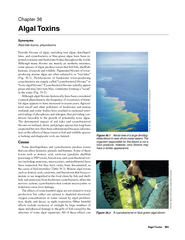
/
Consideration of Temporal and Spatial Dynamics of Vertically Migrating Harmful Algal Blooms Consideration of Temporal and Spatial Dynamics of Vertically Migrating Harmful Algal Blooms

Consideration of Temporal and Spatial Dynamics of Vertically Migrating Harmful Algal Blooms - PowerPoint Presentation

ideassi
ideassi . @ideassi
Follow
344 views
Uploaded On 2020-06-25

Consideration of Temporal and Spatial Dynamics of Vertically Migrating Harmful Algal Blooms - PPT Presentation

Steven E Lohrenz University of Southern Mississippi Gary Kirkpatrick Mote Marine Laboratory Oscar Schofield Rutgers University Overview Introduction Application of satellite ocean color to HAB detection ID: 787399

brevis scales length sampling scales brevis sampling length bloom temporal correlation optical variations hab iops surface resolution spatial rrs

Share:

Link:

Embed:

Download Presentation from below link

Download The PPT/PDF document "Consideration of Temporal and Spatial Dy..." is the property of its rightful owner. Permission is granted to download and print the materials on this web site for personal, non-commercial use only, and to display it on your personal computer provided you do not modify the materials and that you retain all copyright notices contained in the materials. By downloading content from our website, you accept the terms of this agreement.


Presentation Transcript

Slide1

Consideration of Temporal and Spatial Dynamics of Vertically Migrating Harmful Algal Blooms in Support of Developing GEO-CAPE Science and Mission Requirements

Steven E. LohrenzUniversity of Southern MississippiGary KirkpatrickMote Marine LaboratoryOscar SchofieldRutgers University

Slide2

OverviewIntroduction

Application of satellite ocean color to HAB detectionUtility of geostationary ocean color for HAB detectionObjectivesTemporal sampling scalesRadiative transfer modeling of simulated Rrs

Surface correlation lengths scalesApproachDrifter studies and time-series optical profiling and discrete sampling

Radiative

transfer modeling

Underway continuous sampling

Results and Discussion

Conclusions and recommendations

Slide3

IntroductionThe Geostationary Coastal and Air Pollution Events (GEO-CAPE) mission will provide high spectral, spatial and temporal resolution imagery in coastal waters of the continental U.S. Blooms of harmful algae represent a significant and expanding threat to human health and fisheries resources, particularly in coastal waters subject to the influence of anthropogenic

eutrophication In the Gulf of Mexico, the red tide dinoflagellate species Karenia brevis forms recurrent blooms off the west Florida coast

While satellite ocean color has been useful in aiding ground-based surveys for detection and monitoring of K. brevis blooms, the utility for bloom detection has been limited by relatively coarse scale temporal and spatial resolution

Slide4

ObjectivesA systematic analysis of in situ observations is needed to define temporal and spatial scales required to resolve bloom dynamics and provide diagnostic criteria for discrimination of vertically migrating HAB phenomena Here we address the following objectives:

Examine temporal variations in upper water column population distributions and associated inherent optical properties (IOPs) to identify critical temporal sampling scales needed to resolve variationsUse the Hydrolight radiative transfer modeling software in conjunction with measured and modeled IOPs to develop simulated datasets of water leaving radiance in relation to bloom dynamicsExamine length scales of bloom features in relation to sensor spatial resolution

Slide5

ApproachCruise period: 10/1 ā€“ 10/5/2000Study area with drift track overlaid on SeaWiFS

Ocean Color

Slide6

ApproachPeriodic surface sampling was used to identify an area of high concentrations of K.

brevisNear-surface, Davis/CODE-type drifters were used to track bloom patchTime-series optical profiling and discrete sampling of population density and size distribution

surface drifter

ac-9 optical profiler

CTD and water sampling

Slide7

Approach

Radiative

transfer modeling (

Hydrolight

)

K.

brevis

nā€˜(

l

)

,

n(

l

)

K.

brevis

PD, PSD

MIE Theory

CDOM

a

440,

S

a(

l

), b(

l

), b

b

(

l

)

Chl

aph* (K. brevis)

Hydrolight

HyperspectralRrs(l)

Slide8

ApproachUnderway surface sampling of chlorophyll fluorescence to resolve surface correlation length scales

Slide9

ResultsTemporal variations in IOPs

Slide10

ResultsTemporal variations in IOPs

Slide11

Results

Correlation between IOPs and cell densities

Slide12

Results

Temporal variations in K. brevis population density in upper 2 mNeed for multiple daily images

Slide13

ResultsSimulated Rrs in relation to bloom dynamics using three scenariosUniformly mixed water column with varying

K. brevis concentrationsSurface layer of varying concentrationsDeep subsurface layer

Slide14

ResultsUsed measured IOPs and known optical properties and size distributions of K. brevis

(Mahoney, 2003; Craig et al., 2006) as basis for developing scenarios

Slide15

ResultsComparison of modeled (8 x 10⁵ cells L

-1) vs. measured b for upper 3m

Slide16

ResultsAbsorption for CDOM and cells estimated using MIE-modeled absorption signature for K.

brevis and least squares fit to ac-9 absorption to derive CDOM

Slide17

ResultsThese inputs were used to model Rrs for the different scenarios

Slide18

ResultsComparison to measured Rrs ā€“ underestimation of

bbp?

modeled

measured

Slide19

ResultsThird objective was to examine spatial correlation length scales for bloom features

Slide20

ResultsCruise track overlaid on SeaWiFS pixels for 3 Oct 2000 image

Slide21

ResultsFluorescence contour for cruise track from same period

Slide22

ResultsWe examined correlation length scales of two transects

Slide23

ConclusionsTemporal variations in HAB bloom migration necessitates acquisition of multiple daily images to resolve and detectSimulations of Rrs for different HAB vertical distributions showed patterns consistent with prior published work and distinct patterns for different HAB vertical distributions

Correlation length scales for underway were strongly dependent on direction with shortest length scales less than 0.5 km

Slide24

EXTRA SLIDES

Slide25

Effect of Vertical Migration

Reflectance variations

Satlantic HyperTSRB

Schofield et al.,

2006

Slide26

Correlation Length Scales for Different Biological PropertiesResults from Mackas et al. (1984) based on Optical Plankton Counter and fluorescence surveys.

Phytoplankton biomass scales on the order of 4-7 km, however, sampling resolution was only ~1km!

Slide27

Horizontal length scales from Autonomous Underwater Vehicle Observations

Results from Moline et al. (2005).Data were fit to a Generalized Additive Model and smoothed using a loess smoothing function.Sensors included CTD, optical backscatter (OBS), chlorophyll fluorescence (FL) , and bioluminescence (BL).

Slide28

Horizontal length scales from Autonomous Underwater Vehicle ObservationsMoline et al. (2005).Lengths scales based on variogram

analyses ranged from the 50-300 m.

Slide29

Fractal AnalysisFractal analyses of chlorophyll fluorescence reveal break in scaling at ~100 m (characteristic planktoscale) (Lovejoy et al., 2001)Variability at all scales (Lovejoy et al., 2000)

Remote sensing algorithms are strongly scale/resolution dependent

Slide30

Bissett et al.: ApproachHyperspectral datasetPHILLS 2 during the 2001 HyCODE

LEO-15Spectral data at 9 m resolutionLength scales determined by PCA analysis of spectral properties and comparative analysis of relationships of covariance to random noise levels

Slide31

Bissett et al.. Oceanography, 2004

Slide32

Bissett et al., Oceanography, 2004

Slide33

Bissett et al., Oceanography, 2004

Slide34

Bissett et al.: ConclusionsGround Sample Distance of 50-200 m between 1-10 km of shoreSmaller scales may be needed within 1 kmOffshore there is a difference in optimal GSD depending on whether multispectral or

hyperspectral dataset is usedMultispectral suggests 1 km may be adequateHyperspectral suggests higher resolution may be necessary (features not apparent in multispectral)